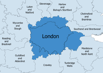
London commuter belt

The London commuter belt is a metropolitan area that includes London and its surrounding commuter zone (the area in which it is practical to commute to work in London). It is also known as the London metropolitan area,[1] or Southeast metropolitan area.[2] It should not be confused with Greater London or the Greater London Built-up Area.
The most up-to-date population figures are from Eurostat, that the London metropolitan area is the largest in the EU with a population of 13,709,128 (in 2011, provisionally 14,431,830 in 2016).[3]
Scope
The boundaries are not fixed; they expand as transport options improve and affordable housing moves further away from city centre.[4] The belt currently covers much of the South East region and part of the East of England region, including the home counties of Hertfordshire, Buckinghamshire, Berkshire, Surrey, Kent and Essex, and, by several definitions, Hampshire, West Sussex, East Sussex and Bedfordshire.
The population of Greater London and those counties adjacent to the green belt was 18,868,800 in 2011. Much of the undeveloped part of this area lies within the designated Metropolitan Green Belt, which covers nearly all of Surrey, eastern Berkshire, southern Buckinghamshire, southern and mid Hertfordshire, southern Bedfordshire, south-west Essex, and western Kent. In addition, three Areas of Outstanding Natural Beauty (the Chiltern Hills, Surrey Hills and North Downs AONBs) surrounding the Thames basin are within the commuter belt.
Definitions
Travel to Work Area
The London Travel to Work Area, defined by the Office for National Statistics as the area for which "of the resident economically active population, at least 75% actually work in the area, and also, that of everyone working in the area, at least 75% actually live in the area."[5] has a population of 9,294,800 (2005 estimate).[6]
Environs of Greater London
There are 17 local government districts that share a boundary with Greater London, in the East and South East regions. Most districts are entirely, or have sections, within the M25 motorway or are within 15–20 miles (24–32 km) of Charing Cross.
Adjacent districts often share characteristics of Outer London, such as forming part of the continuous urban sprawl, being served by the London Underground, being covered by the London telephone area code, (until 2000) forming part of the Metropolitan Police District and having a relatively high employed population working in London.
London's Larger Urban Zone
Larger Urban Zone is a definition created by Eurostat that measures the population and expanse of metropolitan areas across European countries. The population of London's Larger Urban Zone is 11.9 million (2004),[7] ranking it as the largest metropolitan area in the European Union. The districts that are considered parts of this Larger Urban Zone are listed here:[8] no districts in Bedfordshire, Hampshire or Sussex are included. Several large conurbations fall just outside the zone: Reading, Luton, High Wycombe and significant parts of the Aldershot and Crawley Urban Areas.
| Region | County | Districts within London's larger urban zone | Districts outside London's larger urban zone |
|---|---|---|---|
| East | Hertfordshire | North Hertfordshire | |
| Essex | |||
| South East | Kent | ||
| Surrey | |||
| Berkshire | |||
| Buckinghamshire |
Urban areas within the commuter belt
The following table lists urban areas (also known as built-up areas) considered part of the London Commuter Belt with populations over 20,000.[9][10] The commuter belt contains all urban areas within an approximate 40 mile (64 km) radius of Charing Cross. Some of the outermost towns include Aylesbury, Reading, Aldershot and Maidstone.[11][12][13]
Outer Commuter Belt
Some estate agents, including James Pendleton[15] and Savills[16] have defined a 'second commuter belt' further out of London and the home counties. The definition includes places up to approximately 55 miles (89 km) out of central London including Oxford, Hastings and Basingstoke.
See also
References
- ↑ "Greater South East needs strategic investment to secure future". London Development Agency. 18 June 2007. Archived from the original on 25 May 2011.
- ↑ London Assembly Archived 27 May 2008 at the Wayback Machine. – London in its Regional Setting (PDF)
- ↑ "Metropolitan Area Populations". Eurostat. 15 April 2015. Retrieved 8 July 2015.
- ↑ BBC News – The new commuter belt. 18 July 2006.
- ↑ Travel to Work Areas (TTWAs) Archived 1 October 2008 at the Wayback Machine. Beginners' guide to UK geography, Office for National Statistics
- ↑ State of the Cities Database Report on the Urban Competitiveness Theme for: – London TTWA (LA) State of the Cities Database – Department for Communities and Local Government (Mid year population estimates on page 4 of the report)
- ↑ "Archived copy". Archived from the original on 11 December 2011. Retrieved 30 November 2011.
- ↑ http://www.ons.gov.uk/ons/rel/regional-analysis/urban-audit/urban-audit-ii/urban-audit---social-cohesion--london.xls
- ↑ "British urban pattern: population data" (PDF). ESPON project 1.4.3 Study on Urban Functions. European Spatial Planning Observation Network. March 2007. p. 119. Archived from the original (pdf) on 24 September 2015. Retrieved 22 February 2010.
- ↑ "World Gazetteer: London - largest cities (per geographical entity)". 9 February 2013. Archived from the original on 9 February 2013.
- ↑ https://distancecalculator.globefeed.com/UK_Distance_Result.asp?fromplace=Aylesbury%2C%20UK&toplace=London%2C%20UK&dt1=ChIJvc2tLYhXdkgRs_t_WPoQG9g&dt2=ChIJdd4hrwug2EcRmSrV3Vo6llI&sr=dc
- ↑ https://distancecalculator.globefeed.com/UK_Distance_Result.asp?fromplace=Maidstone%2C%20UK&toplace=London%2C%20UK&dt1=ChIJZ3A0-ALW3kcRzQC0DFJi9aY&dt2=ChIJdd4hrwug2EcRmSrV3Vo6llI&sr=dc
- ↑ https://distancecalculator.globefeed.com/UK_Distance_Result.asp?fromplace=Aldershot%2C%20UK&toplace=London%2C%20UK&dt1=ChIJzbecL00rdEgRPLqFQ2ABrhk&dt2=ChIJdd4hrwug2EcRmSrV3Vo6llI&sr=dc
- 1 2 "2011 Census – Built-up areas". ONS. Retrieved 29 June 2013.
- ↑ https://www.loveproperty.com/news/72595/the-secrets-out-londons-new-commuter-belt-revealed
- ↑ https://www.telegraph.co.uk/property/house-prices/revealed-the-31-hotspots-where-house-prices-will-surge-now/
External links
- Calculator for commuter travel times to London from the Home Counties
- London Travel to Work Area mapped with others
- A list of towns considered part of the commuter belt according to World Gazetteer at Archive.is (archived 9 February 2013)