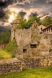
Belgrade Fortress
| Belgrade Fortress | |
|---|---|
|
Београдска тврђава Beogradska tvrđava | |
| Belgrade in Serbia | |
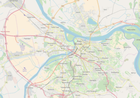
.jpg) Kalemegdan Park and the Fortress | |
 Belgrade Fortress | |
| Coordinates | 44°49′24″N 020°27′01″E / 44.82333°N 20.45028°ECoordinates: 44°49′24″N 020°27′01″E / 44.82333°N 20.45028°E |
| Type | fortress |
| Area | 66 ha (160 acres) |
| Site information | |
| Owner | City of Belgrade |
| Operator | JKP Beogradska Tvrđava |
| Open to the public | Yes |
| Website | Beogradska Tvrđava |
| Site history | |
| Built | 279 BC |
| Built by |
Justinian I (reconstructed in 535) Stefan Lazarević (reconstructed in 1403) Nicolas Doxat de Démoret (reconstructed 1723-36) |
| Materials | Stone |
| Battles/wars | 1440, 1456, 1521, 1688, 1690, 1717, 1739, 1789, 1806. |
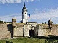
Belgrade Fortress[1][2] (Serbian: Београдска тврђава/Beogradska tvrđava), consists of the old citadel (Upper and Lower Town) and Kalemegdan Park[3] (Large and Little Kalemegdan) on the confluence of the River Sava and Danube, in an urban area of modern Belgrade, the capital of Serbia. It is located in Belgrade's municipality of Stari Grad. Belgrade Fortress was declared a Monument of Culture of Exceptional Importance in 1979, and is protected by the Republic of Serbia.[2] It is the most visited tourist attraction in Belgrade, with Skadarlija being the second.[4] Since the admission is free, it is estimated that the total number of visitors (foreign, domestic, citizens of Belgrade) is over 2 million yearly.[5][6]
Location
Belgrade Fortress is located on top of the 125.5-meter high[7] ending ridge of the Šumadija geological bar. The cliff-like ridge overlooks the Great War Island (Serbian: Veliko ratno ostrvo) and the confluence of the Sava river into the Danube, and makes one of the most beautiful natural lookouts in Belgrade. It borders the neighborhoods of Dorćol (north and north-east), Stari Grad (east) and Kosančićev Venac (Savamala; south). It is encircled by three streets: Boulevard of Vojvoda Bojović, Tadeuša Košćuška, Pariska, and the railway along the riverside.
History
Classical Antiquity
Belgrade Fortress is the core and the oldest section of the urban area of Belgrade. For centuries the city population was concentrated only within the walls of the fortress, and thus the history of the fortress, until most recent times, equals the history of Belgrade itself (see: Timeline of Belgrade history). The first mention of the city is when it was founded in the 3rd century BC as "Singidunum" by the Celtic tribe of Scordisci, who had defeated Thracian and Dacian tribes that previously lived in and around the fort. The city-fortress was later conquered by the Romans, was known as Singidunum and became a part of "the military frontier", where the Roman Empire bordered "barbarian Central Europe". Singidunum was defended by the Roman legion IV Flaviae, which built a fortified camp on a hill at the confluence of the Danube and the Sava rivers. In the period between AD 378 and 441 the Roman camp was repeatedly destroyed in the invasions by the Goths and the Huns. Legend says that Attila's grave lies at the confluence of the Sava and the Danube (under the fortress). In 476 Belgrade again became the borderline between the empires: the Western Roman Empire and Eastern Roman Empire (Byzantine Empire), and the Slav-Avar State in the north.
Middle Ages
The Byzantine Emperor Justinian I rebuilt the fortress around 535. In the following centuries the fortress suffered continuous destruction under the Avar sieges. The Slavs (Serbs) and Avars had their "state union" north of Belgrade with the Serbs and other Slavic tribes finally settling in the Belgrade area as well as the regions west and south of Belgrade in the beginning of the 7th century. The name Belgrade (or Beograd in Serbian), which, not just in Serbian but in most Slavic languages, means a "white town" or a "white fortress", was first mentioned in AD 878 by Bulgarians. The fortress kept changing its masters: Bulgaria during three centuries, and then the Byzantines and then again Bulgarians. The fortress remained a Byzantine stronghold until the 12th century when it fell in the hands of the newly emerging Serbian state. It became a border city of the Serbian Kingdom, later Empire with Hungary. The Hungarian king Béla I gave the fortress to Serbia in the 11th century as a wedding gift (his son married the Serbian princess Jelena), but it remained effectively part of Hungary, except for the period 1282–1319. After the Serbian state collapsed after the Battle of Kosovo, in 1402 Belgrade was chosen as the capital of Despot Stefan Lazarević. Major work was done to the ramparts which were encircling a big thriving town. The lower town at the banks of the Danube was the main urban center with a new built Orthodox cathedral. The upper town with its castle was defending the city from inland. Belgrade remained in Serbian hands for almost a century. After the Despot's death in 1427 it had to be returned to Hungary. An attempt by Sultan Mehmed II to conquer the fortress was prevented by Janos Hunyadi in 1456 (Siege of Belgrade), saving Hungary from Ottoman dominion for 70 years.
Early Modern
In 1521, 132 years after the Battle of Kosovo, the fortress, like most parts of the Serbian state, was conquered by the Turks and remained (with short periods of the Austrian and Serbian occupation), under the rule of the Ottoman Empire until the year 1867, when the Turks withdrew from Belgrade and Serbia. During the short period of Austrian rule (1718–1738), the fortress was largely rebuilt and modernized. It witnessed the Great Serbian Migration in the 17th century and two Serbian Uprisings in the 19th century, during the Turkish Period.
During the Austrian occupation of northern Serbia 1717-39, several hospitals were established in Belgrade. The City hospital of Saint John was built within the fortress walls, but its exact location is not known. Emperor Charles VI signed the Belgrade City Statute in 1724 ("Proclamation on organizing German Belgrade"), which mentions city hospital, city pharmacy, medics and midwives. The German municipality had low incomes so it had to ask the state for help and beneficence. The hospital is mentioned in the 1728 Census. It was a hospital already in 1719, later becoming the residence of Thomas Berger, the head of the hospital. After his death, his daughter continued to reside in the building. The hospital (Stattspital) was moved to another location, into the newly constructed building in 1724. A small church was built next to it. This new hospital was quite small, with only 2 rooms, a kitchen and a basement, so it way not be the same city hospital.[8]
Lazaret or a quarantine hospital is not mentioned in the documents, but it is safe to presume that it had to be formed during the viral outbreaks, as was usual in the time. The procedure in case of outbreaks was probably analog to the existing procedure in Buda, the capital of Hungary. Today unidentified disease ravaged Belgrade in 1730. Viral epidemic killed a lot of people. During the course of only two weeks, just the Jesuits buried 220 people and themselves lost 3 missionaries. The extremely massive plague outbreak hit the city in October 1738. As Austrian army retreated in front of the advancing Turks, numerous civilians fled to the fortress, many of them being contagious. Having so many people in a cramped space, the triage was not possible so the plague spread quickly. There are reports of the dead lying in the streets for days as there was no one to bury them. Austrian garrison was decimated and the corpses of the soldiers who died of plague were burned with their personal properties.[8]
After Austria lost the Austro-Turkish War of 1737–1739, the northern Serbia, including Belgrade, was returned to the Turks. One of the provisions of the 1739 Treaty of Belgrade stated that Austria had to demolish all the fortifications and military and civilian building it has constructed during the occupation. Many Baroque buildings were demolished within the fortress. However, Austria didn't demolish the buildings outside of the fortress walls. That way, the House at 10 Cara Dušana Street, built from 1724 to 1727, in the neighborhood of Dorćol survived, being today the oldest house in Belgrade.[8]
Modern
While it was inhabited, the fortress formed one of the quarters in the administrative division of Belgrade. It was called Grad, and translated in the foreign languages as "fortress". According to the censuses, it had a population of 2,219 in 1890, 2,281 in 1895, 2,777 in 1900, 2,396 in 1905 and 454 in 1910.[9]
Kalemegdan was the location of the second airport in Serbia, after one in the neighborhood of Banjica from 1910. A field in the Donji Grad was adapted for planes in January 1911. It was situated along the bank of the Sava river, from the old Turkish bath (modern Planetarium) to the mouth of the Sava into the Danube. One of the flight pioneers, Edvard Rusjan, died in an airplane crash after taking off from this field on 9 January 1911. Today, the area is used by the parachutists and paragliders and as the location of the air shows for sports and ultra-light aviation.[10][11]
In 1928, building company "Šumadija" proposed the construction of the cable car, which they called "air tram". The project was planned to connect Zemun to Belgrade Fortress, via Great War Island. The interval of the cabins was set at 2 minutes and the entire route was supposed to last 5 minutes. The project was never realized, bud the idea of the cable car was revived in the 21st century.[12]
The fortress suffered further damage during the First and the Second World Wars. After almost two millennia of continuous sieges, battles and conquests, the fortress is today known as the Belgrade Fortress. The present name of Kalemegdan Park derives from two Turkish words, kale (fortress) and meydan (battlefield) (literally, "battlefield fortress").
Archaeology
On 29 February 1952 city adopted the "Decision on protection, adaptation and maintenance of the people's park of Kalemegdan" which set the borders of the protected areas as the rivers of Danube and Sava and the streets of Tadeuša Košćuškog and Pariska. In 1962, Belgrade's Institute for the cultural monuments protection expanded the zone to several blocks across the streets. Detailed plan on Kalemegdan from 1965 provided that, despite the immense archaeological value that lies beneath the fortress ground, basically only what was discovered by that time can be explored, restored or protected. That caused the problem both for the expansion of the park but even more for the further exploration of the fortress' underground. Best example is the Lower Town where neither the park fully developed nor the remains of the former port, which was located there, are visible.[13]
The area of the fortress is 66 ha (160 acres). By 2000, only 5% of that area was archaeologically surveyed, and by 2010 that number rose to 12% or 8 ha (20 acres). Based on the findings so far, it is estimated that during the rule of despot Stefan Lazarević in the first half of the 15th century, when Belgrade became capital of Serbia, the city within the fortress had 5,600 to 12,000 inhabitants. Archaeological examinations were done on the next locations:[14]
- Gornji Grad in the inner fortress; surveyed 1948-2009; found remains belong to the Prehistory, Antiquity, Middle Ages and Turkish-Austrian period;
- waterfront rampart in Donji Grad; 1963-2010; Middle Ages and Turkish-Austrian period;
- Kalemegdan Park; 1973-2010; Antiquity, Middle Ages and Turkish-Austrian period;
- Belgrade Zoo; 1988; Antiquity, Middle Ages and Turkish-Austrian period;
The explored sections after 2000 include the access downhill path to the Small Staircase in Kalemegdan Park, the bastion on the Sava slope, the gates of King, Sava, Dark and Karađorđe, the Great Ravelin, etc.[6]
During the 2017 reconstruction of the Mehmed Paša Sokolović's Fountain, next to the Defterdar's Gate in the Gornji Grad, several archaeological discoveries were made. Remnants of the Roman castrum, two urns from the Bronze Age and remains of the Neolithic object were discovered. The findings were conserved and reburied.[15]
Features
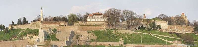
Belgrade Fortress is generally divided into four sections. The four sections, two of which make the fortress itself (Donji and Gornji Grad) and two make a Kalmegdan park today, were divided by the Tsarigrad Road, on the location of modern pedestrian path next to the Cvijeta Zuzorić Art Pavilion.[6]
Lower Town
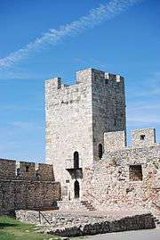
Donji Grad (Доњи Град); occupies the slope towards the riversides, from the top spot (ridge where "The Victor" is). Between the lowest section and the Danube is Kula Nebojša ("Impregnable, Fearless, or Daredevil Tower"), which has been turned into a museum of the Greek revolutionary Rigas Feraios, who was strangled by the Turks in this tower and his corpse thrown into the Danube. Donji Grad, like the neighboring Savamala, frequently suffers from flooding, and Kula Nebojša suffered extensive damage during the major floods of 2006. The Orthodox churches of Ružica (former Austrian gun depot) and Sveta Petka are also located in this area, as is the Belgrade Planetarium.
The modern church of Sveta Petka was projected by architect Momir Korunović. Construction began in the first half of the 1930s, on the location of an old chapel. It was consecrated on 27 October 1937, the feast day of Parascheva of the Balkans, called Petka in Serbian.[16]
During the tenure of mayor Dragan Đilas (2008–13), the idea of expanding the zoo to Donji Grad, which it occupied prior to the World War II, resurfaced, but the experts were against it. The urban plan for the fortress from 1965 already projected the complete relocation of the zoo outside of the fortress, on some of the suburban locations, which in later plans included Veliko Blato, Stepin Lug or Jelezovac. The expansion of the zoo would cut the pedestrian communication between the Danube's and Sava's parts of the fortress, which was already cut in 1949 but was restored in 2009 with the reconstruction and opening of the Sava Gate. Also, it would prevent the exploration of Donji Grad, which is still largely unexplored and leave the Gate of Charles VI, a masterpiece of Balthasar Neumann, within the zoo itself. As of 2017, the zoo was not relocated but the idea of expansion was dropped, too.[6]
Upper Town
Gornji Grad (Горњи Град), the upper section of fortress, turned into a park, with beautiful promenades and the statue of "The Victor" (Serbian: Pobednik), the so-called "Roman well" (Serbian: Rimski bunar), actually built by the Austrians, the Popular Observatory (since 1963) in the Despot Stefan Tower, the türbe (tomb) of Damad Ali Pasha, Mehmed Paša Sokolović's Fountain, tennis and basketball courts, etc.
Bunker
In 1948, after the Informbiro resolution and the ensuing Tito–Stalin split, a construction of the defensive bunker began on the fortress. In the process, the 5 m (16 ft) thick rampart of the original Nebojša Tower was discovered. It was destroyed and by 1949 the bunker which covers 200 m2 (2,200 sq ft) was finished. The tallest point of the bunker is the cannon dome which was used for the artillery and military units. Abandoned later, it was adapted for the tourists and opened in December 2012. It has parts of the authentic inventory from the 1950s: safety doors, beds, ventilation, water tanks, etc.[5]
Damad Ali Pasha's türbe
The türbe is located on the central plateau of the Upper Town and is one of the few remaining monuments of Islamic architecture in Belgrade. It was named after Damad Ali Pasha, a Grand Vizier of the Ottoman Empire 1713-16, during the reign of Sultan Ahmed III. The mausoleum, however, is younger. It was built in 1784 over the grave of Izzet Mehmed Pasha, another Grand Vizier and a muhafiz, or governor, of Belgrade. The türbe was badly damaged during the First Serbian Uprising, so the Ottoman governor of Serbia, Marashli Ali Pasha, reconstructed it in 1818-19 and dedicated it to Damad Ali Pasha. Another two muhafiz, this time administering only the fortress as Serbia gained autonomy, were buried in the türbe: Selim Sirri Pasha in 1847 and Hasan Pasha in 1850.[17]
The mausoleum is made of stone, with a regular hexagonal base. The sides are 4 m (13 ft) long, it is 7 m (23 ft) tall with a diameter of 8 m (26 ft). A thorough renovation began in May 2017 and should be finished by October. The wiring and the roof are replaced, the floor was drained and the inner and outer conservation was done. Old roof tiles were broken so the water poured inside. The roof tiles, which were not the original roof cover, were replaced with the lead cover and new, modern roof tiles, rotten wooden floor was replaced with the brick slabs and the wooden covering of the tomb was also replaced.[17]
Gunpowder magazine
Also adapted for the visits is the Great Austrian gunpowder magazine, built during the Austrian occupation of Belgrade 1718-39, as they destroyed the old one during the 1717 Siege of Belgrade. They directly hit the magazine with the cannonball and the explosion which followed allowed the Austrians to capture the city. The magazine is today embellished with the artifacts from the Roman period which were discovered in or around the fortress: tombstone stelae, monuments, altars and the Sarcophagus of Jonah, which originates from the 3rd century AD.[5] It was arranged and opened for visitors in 2014.[6]
Roman well
The present facility, called the Roman Well, is neither Roman nor a (water) well. It is located along the southwest rampart of the "Gornji Grad", in the vicinity of the Pobednik monument and the "King's Gate". An underground object existed during the mediaeval period and is referenced by Constantine of Kostenets during the rule of Despot Stefan Lazarević, in the first half of the 15th century. It apparently was a dungeon as it was mentioned during the 1456 Siege of Belgrade when 30 Hungarian conspirators died in it after their scheme to let the Turks into the fortress and surrender the city to them was thwarted. They were to be paid by the Turks, but were discovered and dropped into the pit with ropes. They were left there without food and after they began losing their minds from hunger, they were thrown knives to kill each other. Turkish traveler Evliya Çelebi in 1660 wrote about the object as the grain silo.[18][19]
After Austrians occupied the northern Serbia in 1717, it was obvious that there is a problem of providing water for the city within the fortress. Main sources were two large rivers, Danube and Sava, but as Belgrade was quite often under siege or a battleground, it wasn't practical as the rivers would become unreachable during the sieges so they searched for an alternative. Within the scopes of a massive construction and reconstruction of Belgrade in the Baroque manner, from 1717 to 1731 a present facility was dug and a complex wooden mechanism was installed to lift the water up from the pit of 50 m (160 ft). It was designed by Balthasar Neumann. Austrians originally intended to dig a proper water well. They descended to 54 m (177 ft), which is below the water level in the Sava, but found no water and actually hit the impervious rock layer. Then they decided to adapt it into the cistern and to conduct all surface water into it. The mechanism was manually operated, worked on the lever principle and had 12 segments, or pistons, which all worked at the same time when operated. Water was then "climbing", being poured from one vessel into another. Being made of wood, it got rotten and completely disappeared in time, but sometimes it is mentioned as the beginning of the "industrial period" in Belgrade. The copy of the schematics is still being kept in the library of the Matica Srpska in Novi Sad. Neumann also constructed a double spiral staircase which descends 35 m (115 ft) down the shaft and based it on the staircase in the Saint Peter Well in Orvieto, Italy.[18] The diameter of the shaft is 3.4 m (11 ft). The staircase has 212 steps and there is a small corridor at the bottom which connects two sections of the staircase, but it is usually flooded. On Austrian maps, it is named the Great Well, but when Serbian rebels liberated Belgrade from the Ottomans in the early 19th century they gradually named it the Roman Well as the common belief at the time was that all old buildings were Roman.[19]
In 1940 the Yugoslav Royal Army emptied the well, measured it and cleaned it.[19] Because of that, during the World War II an urban myth spread through Belgrade claiming that the gold from the National bank of the Kingdom of Yugoslavia was hidden in the well. German occupation forces sent three divers to check the bottom of the well, but all three disappeared.[18] Some of the Yugoslav soldiers apparently carved a number "1940" near the bottom of the well.[20]
In 1954 a man threw his mistress into the well. Police wanted to prove that he killed her so the divers were dispatched to find the body, but they failed. Still, her body resurfaced ten days later. This story served as an inspiration for Dušan Makavejev when he wrote and directed the movie Love Affair, or the Case of the Missing Switchboard Operator in 1967. In 1964 Alfred Hitchcock visited the well and praised the "ambience". In 1967/68, new exploration of the object was conducted. The divers discovered that the bottom is full of sludge and retrieved a number of skeletons, several animal ones and two human. In 1987 the divers explored whether there is a connected between the well and the Sava, but found no tunnel. The bottom was flat, there was one park bench in the water and a huge number of coins. The Roman Well served as an inspiration for another movie Lavirint, which was nominated by Serbia for an Oscar in 2002. During the 2006 dive, a miniature, 5 mm (0.20 in) long amphipoda, previously undiscovered in Serbia, was found. It was closed in 2007, reconstructed and reopened in March 2014, but as of 2017 the upper section is open for visitors while the descent is forbidden due to the safety reasons.[18][19][20][6]
The divers explored it again in November 2017. The bottom wasn't flat anymore as the bench and coins were covered with a thick layer of some 15 m3 (530 cu ft) of construction waste, iron bars, reflector light, wired trash bins, etc. It all made the well 1.5 m (4 ft 11 in) shallower. Cans, plastic bottles and lids were floating on the water, while a pile of new coins formed. The divers suggested that the well should be cleaned at least once a year. Still, the water was unusually clear, and with artificial reflector light it was transparent all the way to the bottom, or 14 m (46 ft). It had a temperature of 12 °C (54 °F). After 300 years, the speleothems began to form near the bottom of the well.[20]
Existence of another water well, sort of a "twin" of the Roman well, is not widely known today. This well, built on the same principle and being about the same depth, is located away from the fortress, below the modern Monument to Vuk Karadžić in the Vukov Spomenik neighborhood.[21]
Great Kalemegdan Park
Veliki Kalemegdanski park (Велики Калемегдански парк) occupies the southern corner of fortress, with geometrical promenades, the Military Museum, the Museum of Forestry and Hunting, and the Monument of Gratitude to France. At the location of the Monument of Gratitude to France there was a monument to Karađorđe which was dedicated on 21 August 1913, a work of Paško Vučetić. There was a relief with various figures on the sides of the pedestal and Karađorđe's grandson, king Peter I of Serbia attended the dedication. During the Austro-Hungarian occupation of Belgrade in World War I, the Austrians planned to erect the bronze monument to their emperor, Franz Joseph I on that very spot so they melted the Karađorđe's monument to reuse the bronze. When the Franz Joseph monument was being shipped to Belgrade in 1918, Serbian forces captured the ship and confiscated the statue. It was later melted into three church bells, largest of which still tolls from the belltower of the Ružica Church today.[5][22]
Gondola lift
In August 2017 the construction of the gondola lift, which would connect Kalemegdan with Ušće was announced by the city government for 2018.[23] Construction was confirmed in March 2018 when the idea of a pedestrian bridge was dropped after it has been described as "complicated" and "unstable". On the Kalemegdan side, the station will be dug into the hill, 1 m (3 ft 3 in) below the fortress' Sava Promenade. There is a cave 7 m (23 ft) below the projected station, so there is a possibility that the cave will be adapted for visitations and connected to the future gondola station by an elevator. On the Ušćе side, the starting point will be next to the Skate Park, across the Ušće Tower. The entire route is 1 km (0.62 mi) long, of which 300 m (980 ft) will be above the Sava river itself. Estimated cost is €10 million and duration of works 18 months, but it is still not known when the construction will begin.[24] Already existing criticism of the project continued, from the officially used name (gondola instead of a traditional Serbian žičara) and chosen location, to the route, especially the Kalemegdan station which is a collapsible locality above the cave, in the area already prone to mass wasting. Park of the Non-Aligned Countries in the neighborhood of Kosančićev Venac was proposed as the better solution.[25]
Pavilion on Sava Promenade
A pavilion, with an area of 77 m (253 ft) was built in the 1920s along the Sava promenade on the southern edge of the fortress. In the 1990s several families squatted in it. By the 2010s, the object was out of use, derelict and half-ruined. Lease of the object was announced in May 2014, but was recalled. It was repeated in July 2016. On 13 September 2017, without any announcements, the object was demolished. An info table was placed later, saying that the works on the reconstruction began on 15 September, two days after the object was completely razed to the ground. After public and media protests, the city owned communal company which administers the fortress, "Beogradska tvrđava", announced that the terrain is being prepared for the new object, which will have an artistic and cultural, but also a catering function. However, while the "Beogradska tvrđava", obtained a permit from the Ministry of construction, only works which will not affect the construction of the object were allowed, not a demolition. Also, at first they refused to disclose which company is the leaseholder, claiming that the investor pays for everything, though the info board named "Beogradska tvrđava" as an investor. As the entire Kalemegdan area is protected by the law, the State Institute for the monuments protection also had to approve any works. They issued a permit, naming which parts of the object have to be preserved and which may be demolished but, nevertheless, the entire house was demolished. "Beogradska tvrđava" claimed that everything has been done transparent and by the book (biddings, planned investments, etc.) but nothing could be found in the official records.[26][27]
Since then, the leaseholders became known: two companies ("Cig" and "Black Rock"), which are already in the catering business, and which admitted that they planned to build a coffee shop, not to recreate an artistic of cultural pavilion. City sued all three participants, "Beogradska tvrđava", "Cig" and "Black Rock" and on 27 November 2017 the court declared their lease contract void. Only now became known that the contract was signed already on 5 August 2016, while "Cig" and "Black Rock" formed their consortium just one day before. Also, the works were to be finished by the mid-December 2017, after 3 months. Construction inspections visited the site several times and finally ordered the closing of the site and return to the previous state. On their side, State Institute for the monuments protection also banned any further construction. After the demolition, the wholes were dug in the ground, presumably for the new foundations, but in February 2018 the construction yard was abandoned and the dug out holes remained.[28]
Public reactions were negative as from the start it was suspected that a restaurant or a coffee shop will be built. Further controversies, apart from the hidden information and almost absolute ignorance of the reporters and public inquires and refusal of the information disclosing by the "Beogradska tvrđava", were sparked when the bidding paperwork became public in the meantime. Only companies already in the foodservice activities were allowed to participate, even though it was noted that the object is not connected either to the waterworks nor the sewage system, and that there are no requirements to be connected at all.[28]
Ministry of construction confirmed that Ministry of culture issued the permit for archaeological research on the location in December 2017, when the construction site was declared an archaeological dig. Archaeologists made three digs and discovered the artifacts from the Antiquity and the Middle Ages. A fact that the investor didn't provide the proper archaeological survey, which he had to do since it is obligatory when it comes to Kalemegdan, was one of the reasons named for the banning the works by the Institute for the monuments protection.[28]
Little Kalemegdan Park
Mali Kalemegdanski park (Мали Калемегдански парк) occupies the area in the eastern section, which borders the urban section of Belgrade. The northern section of Little Kalemegdan Park is occupied by the Belgrade zoo, opened in 1936. The Cvijeta Zuzorić Art Pavilion is also located here.
Overview
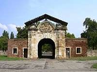
Kalemegdan is the most popular park among Belgraders and for many tourists visiting Belgrade because of the park's numerous winding walking paths, shaded benches, picturesque fountains, statues, historical architecture and scenic river views (Sahat kula – the clock tower; closed in 2007 for the reconstruction, reopened in April 2014,[6] Zindan kapija – Zindan gate, etc.). The former canal which was used for city supplying in the Middle Ages is completely covered by earth but the idea of recreating it resurfaced in the early 2000s. Belgrade Fortress is known for its kilometers-long tunnels, underground corridors and catacombs, which are still largely unexplored. In the true sense, fortress is today the green oasis in the Belgrade's urban area.
As a combination of several habitats (parkland with old trees, fortress, landscape view of rivers and forested Veliko Ratno Ostrvo), Kalemegdan may be interesting for overseas tourists-birdwatchers as it provides a snapshot of local bird fauna. It is also important as the resting spot for small passerine birds on migration, before or after crossing the rivers Sava and Danube. Kalemegdan has its own eBird hotspot and associated webpage at Kalemegdan Hotspot
The Belgrade Race Through History, an annual 6 km footrace, takes place in the park and fortress as a way of highlighting the history and culture of the area.[29]
The Belgrade Fortress was nominated by the Serbian government for the UNESCO's World Heritage Site. Architects and urbanists think that possible inclusion on the list will protect the fortress from "aggressive transitional construction". In that case, the outlines of the fortress and a panoramic view on it will have to be preserved. The perceived visual pollution encompasses several objects. A gigantic object, a late 2000s project by the Zaha Hadid's studio, on the northern side of the fortress, down the slope of Danube. The project, despite some preparatory works, still didn't start off. The other was the spiral project "Cloud" by Sou Fujimoto, which was to connect the Sava port to the fortress, but the project was scrapped after 2013 when the mayoral tenure of Đilas ended.[6] Third is the highly controversial Belgrade Waterfront project.
The fortress in general functions as a major archaeological, artistic and historical treasury. As of 2014 it comprised:[6]
- 19 memorial busts of important people from Serbian history, science and arts (Jovan Skerlić, Miloš Crnjanski, Jovan Dučić, Đura Daničić, Stevan Mokranjac;
- 18 registered archaeological digs (horseshoe towers, remnants of the Metropolitan's palace, Roman Castrum, building of the main guards);
- 6 monuments and memorials (Pobednik, Monument of Gratitude to France, Despot Stefan Lazarević's Monument);
- 4 restaurants and coffee shops
- 4 sports terrains
- 3 sculptures ("Genius of death", "Tired fighter", "Partisan with children")
- 2 fountains ("Awakening", "Fisherman")
- 2 drinking fountains ("Japanese", "Mehmed Paša Sokolović")
- 2 churches (Ružica, Saint Petka)
- 2 galleries (of the Natural Museum, Inner Stambol Gate)
- 2 museums (Military Museum, Nebojša Tower)
- Cvijeta Zuzorić Art Pavilion, City Institute for the protection of the cultural monuments, Belgrade Planetarium, Luna Park, Belgrade Zoo, People's Observatory, Music Pavilion, Serbian Academy of Sciences and Arts' Archaeological Institute's Science and Research Center for the Fortress, Memorial Ossuary for the 1914-15 defenders of Belgrade, Tombs of National Heroes (Moša Pijade, Ivan Milutinović, Đuro Đaković and Ivo Lola Ribar;
Concerts and shows
The flat grounds below the fortress are occasionally used as open-air concert location during late spring and summer:
- 3 September 1997: Partibrejkers
- Belgrade Beer Fest, annually from 2003 until 2007[6]
- 18 June 2011: Amy Winehouse and Moby
- 15 September 2012: Warriors Dance Festival (The Prodigy, Skrillex)
- 24 May 2013: Đorđe Balašević
- 27 May 2013: Green Day (Belgrade Calling Festival, others: Atheist Rap, Superhiks, Hladno Pivo)
- 14 June 2013: Whitesnake
- 22 June 2013: Bajaga i Instruktori
- 17 June 2014: Iron Maiden (Maiden England World Tour, opening act: Ghost)[6]
- 13 August 2017: Interpol
- 27 August 2018: Jessie Ware
- 8 September 2018: 2Cellos
Furthermore, KK Partizan and Red Star concrete basketball courts on the fortress have been used for concerts:
- 26 June 2009: Simply Red (@KK Partizan court)
- 11 July 2011: MTV Free Concert (@KK Partizan court, Rob Garza from Thievery Corporation, Philippe Cohen Solal from Gotan Project, and Gramophonedzie)
- 26 May 2018: Hladno Pivo (@KK Partizan court)
Additionally, a small walled-in part of the fortress near its bottom is known as Barutana. It functions as an open-air club during late spring, summer, and early fall, mostly featuring EDM acts. Among the shows featured in Barutana are:
- 31 July 2016: Talamasca (@Barutana)
- 8 June 2018: Hernán Cattáneo & Nick Warren (@Barutana)
See also
References
- ↑ A official site of Belgrade Fortress
- 1 2 http://www.kultura.gov.rs/?p=901
- ↑ "Archived copy". Archived from the original on 2011-10-09. Retrieved 2011-08-21.
- ↑ Daliborka Mučibabić (21 January 2010). "Skadarlija vraća izgubljeni boemski duh" [Skadarlija recalls the Lost Bohemian Spirit] (in Serbian). Politika.
- 1 2 3 4 Dimitrije Bukvić (29 December 2011), "Kameni "mesojedi" ispod Kalemegdana", Politika (in Serbian)
- 1 2 3 4 5 6 7 8 9 10 11 Daliborka Mučibabić (13 April 2014), "Od vrha Sahat kule do dna Rimskog bunara", Politika (in Serbian)
- ↑ Statistical Yearbook of Belgrade 2007 - Topography, climate and environment Archived 2011-10-07 at the Wayback Machine.
- 1 2 3 Dr. Ana Milošević, D.Stevanović (13 August 2017), "Beogradske bolnice kojih vise nema", Politika-Magazin, No. 1037 (in Serbian), pp. 27–29
- ↑ Претходни резултати пописа становништва и домаће стоке у Краљевини Србији 31 декембра 1910 године, Књига V, стр. 10 [Preliminary results of the census of population and husbandry in Kingdom of Serbia on 31 December 1910, Vol. V, page 10]. Управа државне статистике, Београд (Administration of the state statistics, Belgrade). 1911.
- ↑ Slobodan Kljakić (1 September 2012), "Aeromiting nad Dojnim poljem", Politika (in Serbian)
- ↑ "Istorija: Kalemgdan-Donji Grad (1911)" (in Serbian). Belgrade Nikola Tesla Airport.
- ↑ Dejan Spalović (27 August 2012), "San o žičari od Bloka 44 do Košutnjaka", Politika (in Serbian)
- ↑ Vladimir Bjelikov (September 2011), "U prilog Čodbrani beogradske tvrđave", Politika (in Serbian)
- ↑ Daliborka Mučibabić (5 December 2010), "Mapa zakopanog blaga Beogradske tvrđave", Politika (in Serbian)
- ↑ Milan Janković (23 October 2017), "Od jedan do pet - Nova otkrića" [From 1 to 5 - New discoveries], Politika (in Serbian)
- ↑ Dejan Aleksić (22 April 2018). "Zaboravljeni srpski Gaudi" [Forgotten Serbian Gaudi]. Politika (in Serbian).
- 1 2 Branka Vasiljević (2 October 2017), "Pri kraju radovi na česmi i turbetu" [Work Completed on Fountain and Turbine], Politika (in Serbian), p. 19
- 1 2 3 4 Aleksandra Mijalković, Miroslav Knežević (27 August 2017), "Tajna rimskog bunara u tri dimenzije", Politika-Magazin, No. 1039 (in Serbian), pp. 26–27
- 1 2 3 4 Daliborka Mučibabić (18 September 2013), "Rimski bunar više neće biti zabranjeni grad" [Roman Well will no Longer be a Forbidden Place], Politika (in Serbian), p. 16
- 1 2 3 Dragan Perić (10 December 2017), "Rimski bunar kao trezor Baje Patka" [Roman Well like a vault of Scrooge McDuck], Politika-Magazin, No. 1054 (in Serbian), p. 23
- ↑ Nada Kovačević (2014), "Beograd ispod Beograda" [Belgrad beneath Belgrade], Politika (in Serbian)
- ↑ Dragan Perić (18 February 2018). "Политикин времеплов: Калемегдански цветњак за Карађорђа" [Politika's chronicle: Kalemegdan's flower garden for Karađorđe]. Politika-Magazin, No. 1064 (in Serbian). p. 28.
- ↑ Daliborka Mučibabić (25 August 2017), "Srpski Central park na Ušću" [Serbian Central Park in Ušće], Politika (in Serbian), p. 16
- ↑ Daliborka Mučibabić (10 March 2018). "Gondolom od skejt parka do Kalemegdana" [From Skate Park to Kalemegdan by gondola lift]. Politika (in Serbian).
- ↑ Vlastimir Matić, architect (16 March 2018). "Žičara gde joj mesto nije" [Cable car out of place]. Politika (in Serbian). p. 10.
- ↑ Ana Novaković (28 October 2017). "Prijava Ne da(vi)mo Beograd zbog rušenja na Kalemegdanu" [Report by the "Ne da(vi)mo Beograd" because of the demolition in Kalemegdan] (in Serbian). Balkan Investigative Reporting Network - Javno.rs.
- ↑ Ana Novaković (26 October 2017). "Objekat kulture ili kafana za nepoznatog zakupca" [Object of culture or kafana for the unknown leasholder] (in Serbian). Balkan Investigative Reporting Network - Javno.rs.
- 1 2 3 Ana Novaković (11 April 2018). "Rušenje na Kalemegdanu: Kafana na sudu, ruina u parku" [Demolition on Kalemegdan: Kafana at the court, ruin in the park] (in Serbian). Balkan Investigative Reporting Network - Javno.rs.
- ↑ The Belgrade Race Through History Archived February 7, 2009, at the Wayback Machine.. Belgrade Marathon. Retrieved on 2009-10-15.
External links
| Wikimedia Commons has media related to Kalemegdan. |
For more information, visit the official site of Belgrade Fortress
- 3Digital reconstruction of the Belgrade Fortress as it looked in the 15th century
- A brief history of Belgrade Fortress
- Kalemegdan and the Belgrade fortress
- Kalemegdan images (day and night shots, September 2009)
- The History of Belgrade Fortress

| Official symbols | |||||||||
|---|---|---|---|---|---|---|---|---|---|
| Names and codes | |||||||||
| Cultural icons | |||||||||
| UNESCO |
| ||||||||
| Monuments | |||||||||
| People |
| ||||||||
| Fauna and flora | |||||||||
Category | |||||||||