Fruška Gora
| Fruška Gora Фрушка Гора | |
|---|---|
 | |
| Highest point | |
| Elevation | 539 m (1,768 ft) [1] |
| Coordinates | 45°09′04″N 19°42′40″E / 45.1511°N 19.7111°ECoordinates: 45°09′04″N 19°42′40″E / 45.1511°N 19.7111°E |
| Geography | |
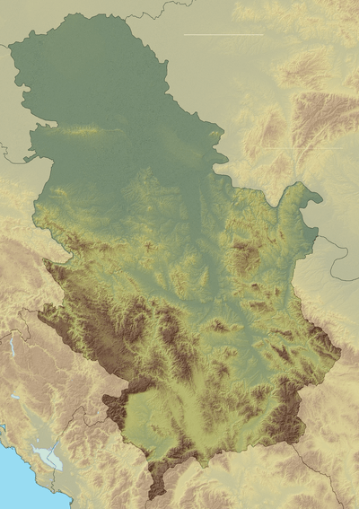 Fruška Gora Фрушка Гора Location in Serbia (map including Kosovo) | |
| Location | Syrmia / Serbia |
| Parent range | Pannonian island mountains |
| Geology | |
| Mountain type | Island mountain |
|
IUCN category II (national park) | |
 Fruška Gora National Park | |
| Area | 266.72 km2 (102.98 sq mi) |
| Established | 1960 |
Fruška Gora (Serbian Cyrillic: Фрушка Гора) is a mountain in north Srem. Most of it is located within the Syrmia region, Serbia, but a smaller part on its western side overlaps the territory of Croatia. Sometimes, it is also referred to as jewel of Serbia, due to its beautiful landscape protection area, nature and its picturesque countryside.
Name
In Serbian, it is known as Fruška gora (pronounced [frûʃkaː ɡǒra], Фрушка гора), in Hungarian as Tarcal (also Almus-hegy or Árpatarló), in German as Frankenwald, and in Latin as Alma Mons. In Medieval Greek, it was known as Frangochoria.
The mountain's name originates in the old Serbian word "Fruzi" of which singular form is "Frug"; and its adjective is Fruški, which was used for naming the Frankish people.[2] The name of "Fruška Gora" is "Frankish mountain" in English whose meaning is based on describing a historical event, viz, the mountain served as a natural border when Frankish campaigns were set up in the area.
In the time of the Roman Empire, its name was Alma Mons, meaning the "fertile mount". It is recorded that during the reign of the emperor Marcus Aurelius Probus, 276-282, who was born in the nearby Sirmium, first grapevines were planted on the mountain.[2]
Geography
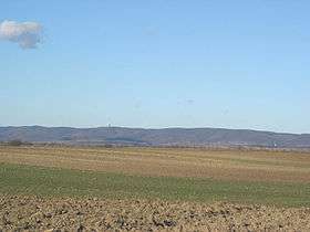
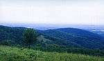
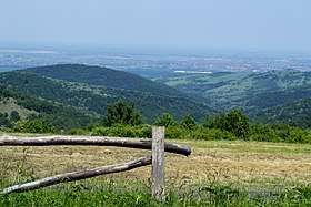
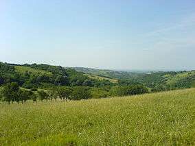
The mountain is a natural geological phenomenon as it is built from the rocks from almost all geological periods.[3] It used to be an island during the existence of the Pannonian Sea. To the north, the mountain is bordered by the Danube river, while to the south it descends into the Syrmian lowlands. Lengthwise, it is approximately 80 km (50 mi) from east to west and is 15 km (9.3 mi) from north to south. Its highest peak is Crveni Čot at 539 m (1,768 ft).[2]
Vineyards
Fruška Gora also divides Syrmia in two geographically distinct parts: Wine Syrmia (upper or mountainous) and Swine Syrmia (lower or lowland). Slopes of the mountain were established as one of the most prestigious vineyards in Hungary, ever since the 15th century. Golden age of the Fruška Gora's viticulture began after 1699 and the Treaty of Karlowitz, when Ottomans were expelled from the area, until the late 19th century.
In Sremski Karlovci, a famous bermet is produced, a sweet, dessert wine with the protected geographical indication. It is recorded that the crates of bermet were used as the bribe, used by the Serbs to obtain certain privileges from the Austrian empress Maria Theresa. The wine was served at the Russian and British courts, and was on the wine list of Titanic.[2]
The slopes of Fruška Gora are perfectly suited for growing grape arbors on there, and there are many wine-makers producing Traminer, Riesling and other wines in the region. Many people have been captivated by its picturesque beauty, due to its outstanding location which is famous for the peaceful and lucrative lifestyles of its inhabitants, and a perfect destination for sightseeing where tourists can relax and enjoy themselves in the spectacular natural environment. After the fall of communism, the Serbian Orthodox Church got 10,000 hectares restitution in the area of their nationalized properties.[4]
National park
A national park Fruška Gora was declared in 1960 and covers an area of 266.72 km2 (102.98 sq mi). It is the oldest modern national park in Serbia.[2]
Rich fossil fauna is preserved and almost 90% of the park area is forested. The predominant tree species include linden, oak and beech. Altogether, 1,500 plant species inhabits the park, of which 200 are protected.[3] There are also 400 species of fungi. Pannonian plant endemites include Tatar dock (Crambe tataria), broadleaf wild leek and Hungarian leopard's-bane. There are some 30 species of orchids in the park.[2]
Protected insect species include Balkan goldenring, certain species of dragonflies and hoverflies, and Hungarian ground beetle, which already went extinct in some other European countries.[2] Park is also the habitat of 13 amphibian species and 11 reptilians, of which 14 are protected, among them fire salamander and European adder.[3]
Park is home to 211 bird species. Symbol of Fruška Gora is eastern imperial eagle, today with only 2 or 3 remaining breeding couples. There are 60 mammalian species, of which 17 are protected, including edible dormouse, European pine marten, European polecat and Mediterranean water shrew.[2] Out of 30 species of bats which live in Serbia, 15 inhabits the mountain and all are under strict protection.[5] In January 2018, for the first time after the 1960s, additional mouflons were introduced in the park. 30 animals were relocated from Slovakia, which raised the number of mouflons in the park to 70.[6]
History
There are traces of human habitation in this area that date from neolithic times. Before the Roman conquest, Illyrians and Celts[2] inhabited this region. In 31 AD, this area was conquered by the Romans and was included into Pannonia province. The Danube river was a border of the Roman Empire (Limes), and on the northern side of the mountain several Roman border fortresses were built.
In the Early Middle Ages, this area was settled by Quadi, Huns, Goths, Gepids, Slavs and Avars. The Franks expelled Huns, Avars, Gepids and Lombards from this area and formed the southern border of the Frankish Empire, ultimately giving its name to the mountain.[2]
It was later inhabited by Bulgarians, Pechenegs and Hungarians. In the 11th century, when Christianity was split between Catholicism and Orthodoxy, both communities had their churches in this region. A very important group of Serb medieval monasteries was formed on the mountain.
Since the 19th century, during the Austro-Hungarian period, cities developed so as the trade and crafts. Settlements on the mountain itself developed, designed in the typical folk tradition. Two most distinct settlements, in terms of architectural inheritance, are Sremski Karlovci, which grew into the center of the political and cultural life of the Serbs in Austria and, later, Austria-Hungary, and Irig, one of the most developed Syrmian settlements since the 18th century.
During the time, the area was part of the Hun Empire, the Ostrogothic Kingdom, the Gepid Kingdom, the Lombard state, the Byzantine Empire, the Avar Khaganate, the Frankish Empire, the Bulgarian Empire, Pannonian Croatia, the Kingdom of Hungary, the Ottoman Empire, the Habsburg Monarchy, the Austrian Empire, Austria-Hungary, the State of Slovenes, Croats and Serbs, the Kingdom of Serbia, the Kingdom of Serbs, Croats and Slovenes, the Kingdom of Yugoslavia, Socialist Federal Republic of Yugoslavia, Serbia and Montenegro, and now is within the Republic of Serbia.
During World War II, this area was occupied by the Axis Powers, and Fruška Gora was an important center of Partisan resistance movement. A liberated partisan territory was formed in this region.
On 28 March 2003, police revealed that former Serbian president Ivan Stambolić had been assassinated by eight men on the mountain. At the time Slobodan Milošević was still in power. It was later determined that Milošević had given the order for Stambolić's murder.
Features
Edreš Hill was used as the quarry by the prehistoric people for their tools. There are numerous Roman remains, like the fortress Acumincum near Slankamen and Bassianae, Roman town near Donji Petrovci. The town was fortified with the ramparts and square towers. Within the walls, the objects with the heating and sewage systems were discovered, so as the walls painted with frescoes and floor mosaics. In 1952, at the locality of Bikić Do, a Roman vault was discovered with 11,500 coins, including ones from the reign of Constantine the Great.[2]
Attractions from the later period include the Tower of Vrdnik, the only remaining part of the medieval fortress, the Rivica Watermill and Stražilovo, where the remains of the poet Branko Radičević were reinterred from Vienna in 1883.[2]
Population and settlements
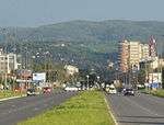
In 1991, the population of the Fruška Gora region numbered at 114,263 people. Settlements in the area include 23 villages, as well as several towns, which are located around the mountain. These towns are: Šid, Beočin, Petrovaradin, Sremska Kamenica, Sremski Karlovci and Irig.
Monasteries

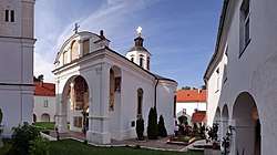
Thanks to its hospitable environment, there are also over a dozen Serbian Orthodox monasteries located on Fruška Gora. According to historical data, these monastic communities were historically recorded since the first decades of the 16th century. Legends, however, place their founding to the period between the 12th and 15th centuries. The monasteries are concentrated in an area 50 kilometers long, and 10 kilometers wide. In the course of centuries of their existence, these monasteries sustained the spiritual and political life of the Serbian nation. In the eighteenth century the monasteries became the home of monks from Rača monastery in the Bajina Bašta municipality by the Drina River. These monks were writers famous for their illuminated manuscripts.
Fruška Gora Monasteries were declared Monuments of Culture of Exceptional Importance in 1990, and are protected by the state.
Ottoman documents mention 35 monasteries, of which 16 survived and are still active today. Due to the such large number of monasteries on one place, Fruška Gora is colloquially called Serbian Mount Athos.[2] The Holy Synod of the Serbian Orthodox Church officially declared Fruška Gora the Holy Mountain on 12 October 2003.[7]
List of monasteries:
- Beočin – The time of founding is still unknown. It is first mentioned in Turkish records dated in 1566/1567.
- Bešenovo – According to the legend, the Bešenovo monastery was founded by Serbian King Dragutin at the end of the 13th century. The earliest historical records about the monastery that can be found date from 1545.
- Divša – It is believed to have been founded by Despot Jovan Branković in the late 15th century. The earliest historical records about the monastery date to the second half of the 16th century.
- Grgeteg – According to tradition the monastery was founded by Zmaj Ognjeni Vuk (Despot Vuk Grgurević) in 1471. The earliest historical records about the monastery that can be found date to 1545/1546. Icons were painted by Uroš Predić.[2]
- Jazak – The monastery was founded in 1736.
- Krušedol – The monastery was founded between 1509 and 1516, by Bishop Maksim (Despot Đorđe Branković) and his mother Angelina. Resting place of king Milan I of Serbia.[2]
- Kuveždin – Traditionally, its foundation is ascribed to Stefan Štiljanović. The first reliable records of it are dated in 1566/1569.
- Mala Remeta – The foundation is traditionally ascribed to the Serbian King Dragutin. The earliest historical records relating to the monastery are dated to the middle of the 16th century.
- Novo Hopovo – According to tradition, the monastery was built by the Despots of the Branković dynasty. The first reliable mention of the monastery is dated to 1641. Dositej Obradović became a monk in this monastery.[2]
- Privina Glava – According to the legends, Privina Glava was founded by a man named Priva, in the 12th century. The earliest historical records about the monastery are dated in 1566/1567.
- Petkovica – According to the tradition, it was founded by the widow of Stefan Štiljanović, Despotess Jelena. The earliest historical records mentioning the monastery are dated to 1566/1567.
- Rakovac – According to a legend written in 1704, Rakovac was founded by a certain man, Raka, courtier of Despot Jovan Branković. The legend states that Raka erected the monastery in 1498. The earliest historical records mentioning the monastery are dated to 1545/1546.
- Staro Hopovo – According to the tradition, the monastery was founded by Bishop Maksim (Despot Đorđe Branković). The first reliable mention of the monastery dates back to 1545/1546.
- Šišatovac – The foundation of the monastery is ascribed to the refugee monks from the Serbian monastery of Žiča. The reliable facts illustrating the life of the monastery date back from the mid 16th century.
- Velika Remeta – Traditionally, its founding is linked to King Dragutin at the end of the 13th century. The earliest historical records about the monastery date to 1562.
- Vrdnik-Ravanica – The exact date of its founding is unknown. The records indicate that the church was built at the time of Metropolitan Serafim Jovanović, in the second half of the 16th century. It holds the reliquary of Prince Lazar and his partial relics.[2]
See also
References
- ↑ Jovan Đokić. "Katalog planina Srbije". PSD Kopaonik Beograd. Archived from the original on 2011-05-18.
- 1 2 3 4 5 6 7 8 9 10 11 12 13 14 15 16 17 Dimitrije Bukvić (24 July 2017), "Pod krilima orla krstaša", Politika (in Serbian), pp. 01 & 08
- 1 2 3 Aleksandra Mijalković (18 June 2017), "O očuvanju naše prirodne baštine: najbolja zaštita u naconalnim parkovima", Politika-Magazin (in Serbian), pp. 3–6
- ↑ Crkva neće novac za šume Archived 28 December 2008 at the Wayback Machine.
- ↑ Snežana Kovačević (27 August 2017), "Kako zavoleti šišmiša", Politika-Magazin, No. 1039 (in Serbian), p. 24
- ↑ Slavica Stuparušić (6 February 2018). "Sve vise muflona na Fruškoj Gori" [More and more mouflons on Fruška Gora]. Politika (in Serbian). p. 08.
- ↑ S.Kovačević (8 August 2017), "Fruška sveta gora nije u turističkoj ponudi Srbije", Politika (in Serbian), p. 08
Sources
- Slobodan Ćurčić - Olivera Dobrivojević - Gordana Stojaković, Fruška gora: turistički vodič, Novi Sad - Beograd, 2002.
- Milorad Grujić, Vodič kroz Novi Sad i okolinu, Novi Sad, 2004.
- Gvozden Perković, Verski objekti na tlu Vojvodine, Novi Sad, 2006.
External links
| Wikimedia Commons has media related to Fruška Gora. |
Gallery
|