Beiarn
| Beiarn kommune | |||
|---|---|---|---|
| Municipality | |||
 | |||
| |||
 Beiarn within Nordland | |||
| Coordinates: 66°55′02″N 14°40′29″E / 66.91722°N 14.67472°ECoordinates: 66°55′02″N 14°40′29″E / 66.91722°N 14.67472°E | |||
| Country | Norway | ||
| County | Nordland | ||
| District | Salten | ||
| Established | 1853 | ||
| Administrative centre | Moldjord | ||
| Government | |||
| • Mayor (2011) | Monika Sande (Sp) | ||
| Area | |||
| • Total | 1,222.32 km2 (471.94 sq mi) | ||
| • Land | 1,180.94 km2 (455.96 sq mi) | ||
| • Water | 41.38 km2 (15.98 sq mi) | ||
| Area rank | #81 in Norway | ||
| Population (2017) | |||
| • Total | 1,043 | ||
| • Rank | #391 in Norway | ||
| • Density | 0.9/km2 (2/sq mi) | ||
| • Change (10 years) | -9.1% | ||
| Demonym(s) | Beiarværing[1] | ||
| Time zone | UTC+01:00 (CET) | ||
| • Summer (DST) | UTC+02:00 (CEST) | ||
| ISO 3166 code | NO-1839 | ||
| Official language form | Bokmål | ||
| Website |
beiarn | ||
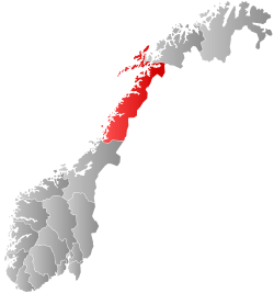
Beiarn is a municipality in Nordland county, Norway. It is part of the traditional district of Salten. Beiarn is also a part of the Bodø Region, a statistical metropolitan region. The administrative centre of the municipality is the village of Moldjord. Other villages in Beiarn are Høyforsmoen, Trones, and Tverrvika.
The 1,222-square-kilometre (472 sq mi) municipality is the 81st largest by area out of the 422 municipalities in Norway. Beiarn is the 391st most populous municipality in Norway with a population of 1,043. The municipality's population density is 0.9 inhabitants per square kilometre (2.3/sq mi) and its population has decreased by 9.1% over the last decade.[2]
General information
The municipality of Beiarn was established in 1853 when it was separated from the large municipality of Gildeskål. Initially, Beiarn had 1,164 residents. The municipal boundaries have not changed since that time.[3]
Name
The municipality is named after Beiar Fjord (Old Norse: Beðir or Beðinn). The meaning of the name is not definitively known, but it may be related to the English word bed in the sense of a "river bed". The name was historically spelled Beieren.[4]

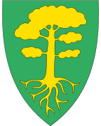
Coat-of-arms
The coat-of-arms is from modern times; they were granted in 1988. The arms show a gold-colored pine tree on a green background. This was chosen because of the mighty pine forests for which Beiarn has historically been well-known.[5][6]
Churches
The Church of Norway has one parish (sokn) within the municipality of Beiarn. It is part of the Salten prosti (deanery) in the Diocese of Sør-Hålogaland.
| Parish (Sokn) | Church Name | Location of the Church | Year Built |
|---|---|---|---|
| Beiarn | Beiarn Church | Moldjord | 1873 |
| Høyforsmoen Chapel | Høyforsmoen | 1957 |
A privately owned stave church was built in 2006 at Savjord, about 8 kilometres (5.0 mi) east of Moldjord. The Savjord Stave Church was modeled after the Gol Stave Church.
Geography

The municipality of Beiarn is located just north of the Arctic Circle, along the Beiar River including the Beiar Valley and some surrounding areas in the Saltfjellet mountains. The river is one of the best salmon rivers in Northern Norway. There are several large lakes in Beiarn including Arstaddalsdammen, Litle Sokumvatnet, and Ramsgjelvatnet.
The Saltfjellet–Svartisen National Park is partially located in Beiarn. The world's most northern naturally occurring elm forest (Ulmus glabra) grows in the Arstadlia nature reserve, where the rich vegetation also includes orchids.[7]
Government
All municipalities in Norway, including Beiarn, are responsible for primary education (through 10th grade), outpatient health services, senior citizen services, unemployment and other social services, zoning, economic development, and municipal roads. The municipality is governed by a municipal council of elected representatives, which in turn elect a mayor.
Municipal council
The municipal council (Kommunestyre) of Beiarn is made up of 15 representatives that are elected to four year terms. Currently, the party breakdown is as follows:[8]
| Party Name | Name in Norwegian | Number of representatives | |
|---|---|---|---|
| Labour Party | Arbeiderpartiet | 6 | |
| Centre Party | Senterpartiet | 5 | |
| Local Lists | Lokale lister | 4 | |
| Total number of members: | 15 | ||
Attractions
The area offers many outdoor activities to visitors, including fishing, caving, and mountain walking. The Beiarn farm museum includes an overview of Beiarn's cultural history, from the Viking Age through to the middle of the 20th century.
See also
References
- ↑ "Navn på steder og personer: Innbyggjarnamn" (in Norwegian). Språkrådet. Retrieved 2015-12-01.
- ↑ Statistisk sentralbyrå (2017). "Table: 06913: Population 1 January and population changes during the calendar year (M)" (in Norwegian). Retrieved 2017-09-09.
- ↑ Jukvam, Dag (1999). "Historisk oversikt over endringer i kommune- og fylkesinndelingen" (PDF) (in Norwegian). Statistisk sentralbyrå.
- ↑ Rygh, Oluf (1905). Norske gaardnavne: Nordlands amt (in Norwegian) (16 ed.). Kristiania, Norge: W. C. Fabritius & sønners bogtrikkeri. p. 193.
- ↑ "Om Kommunevåpenet". Beiarn kommune. Retrieved 2008-11-19.
- ↑ Store norske leksikon. "Beiarn" (in Norwegian). Retrieved 2012-03-26.
- ↑ "Arstadlia-Tverviknakken naturreservat" (in Norwegian). Archived from the original on 2007-09-29. Retrieved 2008-11-19.
- ↑ "Table: 04813: Members of the local councils, by party/electoral list at the Municipal Council election (M)" (in Norwegian). Statistics Norway. 2015.
External links
- Municipal fact sheet from Statistics Norway (in Norwegian)
| Wikimedia Commons has media related to Beiarn. |

- Beiarn municipality (in Norwegian)
- Elm in Norway (in Norwegian)
- Elm (in Norwegian)
- About Tvervik in Beiarn (in Norwegian)
| |||||||||||||||||
| |||||||||||||||||