Beallsville, Pennsylvania
| Beallsville | |
|---|---|
| Borough | |
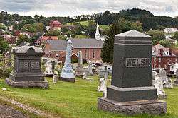 Overview from the community cemetery | |
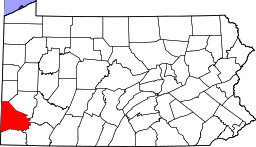
 Location of Beallsville in Washington County, Pennsylvania. | |
 Beallsville Location of Beallsville in Pennsylvania | |
| Coordinates: 40°3′53″N 80°1′29″W / 40.06472°N 80.02472°WCoordinates: 40°3′53″N 80°1′29″W / 40.06472°N 80.02472°W | |
| Country | United States |
| State | Pennsylvania |
| County | Washington |
| Established | 1819 |
| Government | |
| • Mayor | Richard Settles |
| Area[1] | |
| • Total | 2.43 sq mi (6.29 km2) |
| • Land | 2.43 sq mi (6.29 km2) |
| • Water | 0.00 sq mi (0.00 km2) |
| Population (2010) | |
| • Total | 466 |
| • Estimate (2016)[2] | 445 |
| • Density | 183.28/sq mi (70.78/km2) |
| Time zone | UTC-4 (EST) |
| • Summer (DST) | UTC-5 (EDT) |
| Area code(s) | 724 |
Beallsville is a borough in Washington County, Pennsylvania, United States and part of the Pittsburgh metropolitan area since 1950.[3] The population was 511 at the 2000 census. Much of the borough has been designated the Beallsville Historic District.
History
A post office called Beallsville has been in operation since 1822.[4] Beallsville was named for Zephaniah Bealle, a pioneer settler.[5] The borough was incorporated in 1852.[5]
Geography
Beallsville is located at 40°3′53″N 80°1′29″W / 40.06472°N 80.02472°W (40.064608, -80.024814).[6]
According to the United States Census Bureau, the borough has a total area of 2.4 square miles (6.2 km2), all of it land.
Surrounding neighborhoods
Beallsville has three borders, including West Pike Run Township to the north and east, Deemston to the south, and North Bethlehem Township to the west.
Demographics
| Historical population | |||
|---|---|---|---|
| Census | Pop. | %± | |
| 1860 | 357 | — | |
| 1870 | 297 | −16.8% | |
| 1880 | 376 | 26.6% | |
| 1890 | 360 | −4.3% | |
| 1900 | 388 | 7.8% | |
| 1910 | 407 | 4.9% | |
| 1920 | 445 | 9.3% | |
| 1930 | 581 | 30.6% | |
| 1940 | 604 | 4.0% | |
| 1950 | 598 | −1.0% | |
| 1960 | 481 | −19.6% | |
| 1970 | 434 | −9.8% | |
| 1980 | 588 | 35.5% | |
| 1990 | 530 | −9.9% | |
| 2000 | 511 | −3.6% | |
| 2010 | 466 | −8.8% | |
| Est. 2016 | 445 | [2] | −4.5% |
| Sources:[7][8][9] | |||
As of the census[8] of 2000, there were 511 people, 196 households, and 147 families residing in the borough. The population density was 210.6 people per square mile (81.2/km²). There were 216 housing units at an average density of 89.0 per square mile (34.3/km²). The racial makeup of the borough was 99.22% White and 0.78% African American.
There were 196 households out of which 29.6% had children under the age of 18 living with them, 64.3% were married couples living together, 9.7% had a female householder with no husband present, and 25.0% were non-families. 22.4% of all households were made up of individuals and 10.2% had someone living alone who was 65 years of age or older. The average household size was 2.61 and the average family size was 3.08.
In the borough the population was spread out with 23.7% under the age of 18, 7.8% from 18 to 24, 25.0% from 25 to 44, 29.2% from 45 to 64, and 14.3% who were 65 years of age or older. The median age was 41 years. For every 100 females there were 94.3 males. For every 100 females age 18 and over, there were 90.2 males.
The median income for a household in the borough was $37,656, and the median income for a family was $41,667. Males had a median income of $32,250 versus $26,250 for females. The per capita income for the borough was $15,917. About 10.8% of families and 10.7% of the population were below the poverty line, including 15.9% of those under age 18 and 11.7% of those age 65 or over.
References
- ↑ "2016 U.S. Gazetteer Files". United States Census Bureau. Retrieved Aug 14, 2017.
- 1 2 "Population and Housing Unit Estimates". Retrieved June 9, 2017.
- ↑
- ↑ "Washington County". Jim Forte Postal History. Archived from the original on 13 January 2016. Retrieved 4 October 2015.
- 1 2 "Towns to mark birthday with celebration". The Pittsburgh Press. Jun 25, 1916. p. 22. Retrieved 29 October 2015.
- ↑ "US Gazetteer files: 2010, 2000, and 1990". United States Census Bureau. 2011-02-12. Retrieved 2011-04-23.
- ↑ "Census of Population and Housing". U.S. Census Bureau. Archived from the original on 12 May 2015. Retrieved 11 December 2013.
- 1 2 "American FactFinder". United States Census Bureau. Archived from the original on 2013-09-11. Retrieved 2008-01-31.
- ↑ "Incorporated Places and Minor Civil Divisions Datasets: Subcounty Resident Population Estimates: April 1, 2010 to July 1, 2012". Population Estimates. U.S. Census Bureau. Archived from the original on 17 June 2013. Retrieved 11 December 2013.
| Counties |  Map of the Pittsburgh Tri-State with green counties in the metropolitan area and yellow counties in the combined area. | |
|---|---|---|
| Major cities | ||
| Cities and towns 15k-50k (in 2010) | ||
| Airports | ||
| Topics | ||
| ||