Burgettstown, Pennsylvania
| Burgettstown | |
|---|---|
| Borough | |
.jpg) | |
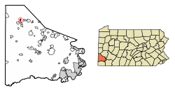 Location of Burgettstown in Washington County, Pennsylvania. | |
 Burgettstown Location of Burgettstown in Pennsylvania | |
| Coordinates: 40°22′51″N 80°23′28″W / 40.38083°N 80.39111°WCoordinates: 40°22′51″N 80°23′28″W / 40.38083°N 80.39111°W | |
| Country | United States |
| State | Pennsylvania |
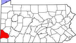
| County | Washington |
| Established | 1795 |
| Government | |
| • Mayor | Settimio Carnali |
| Area[1] | |
| • Total | 0.62 sq mi (1.61 km2) |
| • Land | 0.62 sq mi (1.61 km2) |
| • Water | 0.00 sq mi (0.00 km2) |
| Population (2010) | |
| • Total | 1,388 |
| • Estimate (2016)[2] | 1,333 |
| • Density | 2,143.09/sq mi (827.93/km2) |
| Time zone | UTC-4 (EST) |
| • Summer (DST) | UTC-5 (EDT) |
| Area code(s) | 724 |
Burgettstown is a borough in Washington County, Pennsylvania, United States. It is a suburb of Pittsburgh, Pennsylvania. The population was 1,576 according to the 2000 census.
Burgettstown is home to KeyBank Pavilion, a 23,000-seat, outdoor amphitheater that hosts concerts throughout the summer.
History
Burgettstown was laid out in 1795 by Sebastian Burgett, and named for him.[3]
Geography
Burgettstown is located at 40°22′51″N 80°23′28″W / 40.38083°N 80.39111°W (40.380844, -80.391047).[4]
According to the United States Census Bureau, the borough has a total area of 0.6 square miles (1.6 km2), all of it land.
Surrounding communities
Burgettstown is surrounded entirely by Hanover Township. Nearby communities include Joffre, Bulger, Cherry Valley, Atlasburg, Slovan, Langeloth, Eldersville, Florence, Paris, and Studa.
Demographics
| Historical population | |||
|---|---|---|---|
| Census | Pop. | %± | |
| 1880 | 876 | — | |
| 1890 | 929 | 6.1% | |
| 1900 | 961 | 3.4% | |
| 1910 | 1,268 | 31.9% | |
| 1920 | 1,990 | 56.9% | |
| 1930 | 2,266 | 13.9% | |
| 1940 | 2,497 | 10.2% | |
| 1950 | 2,379 | −4.7% | |
| 1960 | 2,383 | 0.2% | |
| 1970 | 2,118 | −11.1% | |
| 1980 | 1,867 | −11.9% | |
| 1990 | 1,634 | −12.5% | |
| 2000 | 1,576 | −3.5% | |
| 2010 | 1,388 | −11.9% | |
| Est. 2016 | 1,333 | [2] | −4.0% |
| Sources:[5][6][7] | |||
As of the census[6] of 2000, there were 1,576 people, 656 households, and 429 families residing in the borough. The population density was 2,531.8 people per square mile (981.4/km²). There were 703 housing units at an average density of 1,129.3 per square mile (437.8/km²). The racial makeup of the borough was 96.26% White, 1.46% African American, 0.06% Native American, 0.06% Asian, 0.51% from other races, and 1.65% from two or more races. Hispanic or Latino of any race were 2.47% of the population.
There were 656 households out of which 25.5% had children under the age of 18 living with them, 45.6% were married couples living together, 14.3% had a female householder with no husband present, and 34.6% were non-families. 31.3% of all households were made up of individuals and 17.8% had someone living alone who was 65 years of age or older. The average household size was 2.34 people and the average family size was 2.93.
In the borough the population was spread out with 21.6% under the age of 18, 5.2% from 18 to 24, 28.0% from 25 to 44, 23.0% from 45 to 64, and 22.2% who were 65 years of age or older. The median age was 42 years. For every 100 females, there were 86.5 males. For every 100 females age 18 and over, there were 79.4 males.
The median income for a household in the borough was $33,350, and the median income for a family was $39,271. Males had a median income of $32,885 versus $23,375 for females. The per capita income for the borough was $16,097. About 7.6% of families and 10.3% of the population were below the poverty line, including 12.8% of those under age 18 and 6.9% of those age 65 or over.
Points of interest
- Burgettstown Area Middle/High School, local public school that recently completed renovations for new classrooms, gymnasium and auditorium
- Burgettstown Community Library, 2 Kerr Street, home of the Ft. Vance Historical Society and the Washington-Greene County chapter of the Pennsylvania Sports Hall of Fame.
Notable residents
- Joe Tepsic - Major League Baseball outfielder for the Brooklyn Dodgers
- Robert Linn - 3rd-longest serving mayor of all time, served 58 years of service in Beaver, Pennsylvania
- Barry Alvarez - former University of Wisconsin head football coach
References
| Wikimedia Commons has media related to Burgettstown, Pennsylvania. |
- ↑ "2016 U.S. Gazetteer Files". United States Census Bureau. Retrieved Aug 14, 2017.
- 1 2 "Population and Housing Unit Estimates". Retrieved June 9, 2017.
- ↑ The Pennsylvania Magazine of History and Biography. Publication Fund of the Historical Society of Pennsylvania. 1886. p. 135.
- ↑ "US Gazetteer files: 2010, 2000, and 1990". United States Census Bureau. 2011-02-12. Retrieved 2011-04-23.
- ↑ "Census of Population and Housing". U.S. Census Bureau. Archived from the original on 12 May 2015. Retrieved 11 December 2013.
- 1 2 "American FactFinder". United States Census Bureau. Archived from the original on 2013-09-11. Retrieved 2008-01-31.
- ↑ "Incorporated Places and Minor Civil Divisions Datasets: Subcounty Resident Population Estimates: April 1, 2010 to July 1, 2012". Population Estimates. U.S. Census Bureau. Archived from the original on 17 June 2013. Retrieved 11 December 2013.
| Counties |  Map of the Pittsburgh Tri-State with green counties in the metropolitan area and yellow counties in the combined area. | |
|---|---|---|
| Major cities | ||
| Cities and towns 15k-50k (in 2010) | ||
| Airports | ||
| Topics | ||
| ||