Marianna, Pennsylvania
| Marianna | |
|---|---|
| Borough | |
_2nd_St.jpg) Houses on Second Street | |
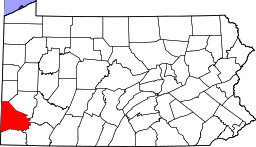
 Location of Marianna in Washington County, Pennsylvania. | |
 Marianna Location of Marianna in Pennsylvania | |
| Coordinates: 40°0′56″N 80°6′38″W / 40.01556°N 80.11056°WCoordinates: 40°0′56″N 80°6′38″W / 40.01556°N 80.11056°W | |
| Country | United States |
| State | Pennsylvania |
| County | Washington |
| Established | 1907 |
| Government | |
| • Mayor | Jeremy A. Berardinelli </ |
| Area[1] | |
| • Total | 1.96 sq mi (5.07 km2) |
| • Land | 1.96 sq mi (5.07 km2) |
| • Water | 0.00 sq mi (0.00 km2) |
| Population (2010) | |
| • Total | 494 |
| • Estimate (2016)[2] | 475 |
| • Density | 242.84/sq mi (93.74/km2) |
| Time zone | UTC-4 (EST) |
| • Summer (DST) | UTC-5 (EDT) |
| Area code(s) | 724 Exchange: 267 |
Marianna is a borough in Washington County, Pennsylvania, United States. The population was 626 at the 2000 census.
History
Marianna was built as a mining town for the Pittsburg Buffalo Company in 1907 and was incorporated in 1910. At the time of its construction, the Marianna Mine was among the most modern and well equipped in the world. The town's brick homes were designed to offer indoor bathrooms, fenced yards and other amenities making living conditions very attractive for the time.
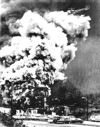
At 10:55 a.m. on the morning of Saturday, November 28, 1908, an explosion occurred in the mine which killed 154 men and left only one survivor.[3][4] Although the mine was quickly refurbished by the Pittsburg Buffalo Company, the colliery's fortunes flagged. By 1914, the mine was sold to the Union Coal and Coke Company and later to Bethlehem Steel which continued to extract coal until 1988, when the main conveyor caught fire. The fire was extinguished, but the mine closed anyway.
The Marianna Historic District was listed on the National Register of Historic Places in 1984.[5]
Geography
Marianna is located at 40°0′56″N 80°6′38″W / 40.01556°N 80.11056°W (40.015626, -80.110483).[6]
According to the United States Census Bureau, the borough has a total area of 2.0 square miles (5.2 km2), all of it land.
Demographics
| Historical population | |||
|---|---|---|---|
| Census | Pop. | %± | |
| 1910 | 1,363 | — | |
| 1920 | 1,124 | −17.5% | |
| 1930 | 1,762 | 56.8% | |
| 1940 | 1,493 | −15.3% | |
| 1950 | 1,269 | −15.0% | |
| 1960 | 1,088 | −14.3% | |
| 1970 | 875 | −19.6% | |
| 1980 | 907 | 3.7% | |
| 1990 | 616 | −32.1% | |
| 2000 | 626 | 1.6% | |
| 2010 | 494 | −21.1% | |
| Est. 2016 | 475 | [2] | −3.8% |
| Sources:[7][8][9] | |||
As of the census[8] of 2000, there were 626 people, 236 households, and 157 families residing in the borough. The population density was 320.3 people per square mile (123.9/km²). There were 259 housing units at an average density of 132.5 per square mile (51.3/km²). The racial makeup of the borough was 89.14% White, 8.79% African American, 0.80% Native American, and 1.28% from two or more races.
There were 236 households out of which 33.1% had children under the age of 18 living with them, 50.4% were married couples living together, 13.1% had a female householder with no husband present, and 33.1% were non-families. 29.2% of all households were made up of individuals and 16.1% had someone living alone who was 65 years of age or older. The average household size was 2.65 and the average family size was 3.30.
In the borough the population was spread out with 29.9% under the age of 18, 7.8% from 18 to 24, 28.1% from 25 to 44, 19.0% from 45 to 64, and 15.2% who were 65 years of age or older. The median age was 33 years. For every 100 females there were 85.8 males. For every 100 females age 18 and over, there were 84.5 males.
The median income for a household in the borough was $28,333, and the median income for a family was $31,750. Males had a median income of $24,688 versus $20,893 for females. The per capita income for the borough was $11,925. About 14.2% of families and 19.3% of the population were below the poverty line, including 35.1% of those under age 18 and 7.8% of those age 65 or over.
References
- ↑ "2016 U.S. Gazetteer Files". United States Census Bureau. Retrieved Aug 14, 2017.
- 1 2 "Population and Housing Unit Estimates". Retrieved June 9, 2017.
- ↑ Horton, Frederick (1913). Coal-mine accidents in the United States, 1896-1912 with monthly statistics for 1912. United States Bureau of Mines. p. 70.
- ↑ Jon Stevens. "Marianna: 152 Dead In One Horrible Instant". Washington Observer-Reporter. Retrieved 2017-04-25.
- ↑ National Park Service (2010-07-09). "National Register Information System". National Register of Historic Places. National Park Service.
- ↑ "US Gazetteer files: 2010, 2000, and 1990". United States Census Bureau. 2011-02-12. Retrieved 2011-04-23.
- ↑ "Census of Population and Housing". U.S. Census Bureau. Retrieved 11 December 2013.
- 1 2 "American FactFinder". United States Census Bureau. Retrieved 2008-01-31.
- ↑ "Incorporated Places and Minor Civil Divisions Datasets: Subcounty Resident Population Estimates: April 1, 2010 to July 1, 2012". Population Estimates. U.S. Census Bureau. Archived from the original on 17 June 2013. Retrieved 11 December 2013.
External links
- Photo documentation of Marianna's coal mining past.
- Marianna, PA Mine Explosion Disaster, Nov 1908 at GenDisasters.com.
| Counties |  Map of the Pittsburgh Tri-State with green counties in the metropolitan area and yellow counties in the combined area. | |
|---|---|---|
| Major cities | ||
| Cities and towns 15k-50k (in 2010) | ||
| Airports | ||
| Topics | ||
| ||
Deadliest coal mine disasters in the United States | ||
|---|---|---|
|  | |