Union Township, Washington County, Pennsylvania
| Union Township | |
|---|---|
| Township | |
 The historic Mingo Creek Presbyterian Church and Churchyard | |
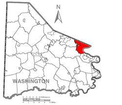 Location of Union Township in Washington County | |
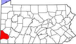 Location of Washington County in Pennsylvania | |
| Country | United States |
| State | Pennsylvania |
| County | Washington County |
| Established | March 31, 1836 |
| Area[1] | |
| • Total | 15.75 sq mi (40.79 km2) |
| • Land | 15.38 sq mi (39.83 km2) |
| • Water | 0.37 sq mi (0.96 km2) |
| Population (2010) | |
| • Total | 5,700 |
| • Estimate (2016)[2] | 5,725 |
| • Density | 372.24/sq mi (143.72/km2) |
| Time zone | UTC-4 (EST) |
| • Summer (DST) | UTC-5 (EDT) |
| Area code(s) | 724 |
| Website | uniontwp.psatstwp.org |
| Historical population | |||
|---|---|---|---|
| Census | Pop. | %± | |
| 2000 | 5,599 | — | |
| 2010 | 5,700 | 1.8% | |
| Est. 2016 | 5,725 | [2] | 0.4% |
| U.S. Decennial Census[3] | |||
Union Township is a township in Washington County, Pennsylvania, United States. The population was 5,700 at the 2010 census.[4]
History
The Dusmal House and Mingo Creek Presbyterian Church and Churchyard are listed on the National Register of Historic Places.[5]
Geography
According to the United States Census Bureau, the township has a total area of 15.7 square miles (40.8 km²), of which, 15.4 square miles (39.8 km²) of it is land and 0.4 square miles (1.0 km²) of it (2.41%) is water.
Surrounding, adjacent and inner neighborhoods
Union Township has five land borders, including South Park Township and Jefferson Hills (both in Allegheny County) to the north, Carroll Township to the south, and Nottingham and Peters Townships to the west. Across the Monongahela River in Allegheny County, Union Township runs adjacent with Forward Township in Allegheny County. The separate borough of Finleyville is located entirely within the west-northwest section of the township.
Demographics
As of the census[6] of 2000, there were 5,599 people, 2,300 households, and 1,674 families residing in the township. The population density was 364.3 people per square mile (140.6/km²). There were 2,376 housing units at an average density of 154.6/sq mi (59.7/km²). The racial makeup of the township was 98.25% White, 0.68% African American, 0.04% Native American, 0.16% Asian, 0.23% from other races, and 0.64% from two or more races. Hispanic or Latino of any race were 0.54% of the population.
There were 2,300 households out of which 27.5% had children under the age of 18 living with them, 59.0% were married couples living together, 10.7% had a female householder with no husband present, and 27.2% were non-families. 24.0% of all households were made up of individuals and 12.0% had someone living alone who was 65 years of age or older. The average household size was 2.43 and the average family size was 2.88.
In the township the population was spread out with 21.0% under the age of 18, 5.7% from 18 to 24, 28.6% from 25 to 44, 26.9% from 45 to 64, and 17.8% who were 65 years of age or older. The median age was 42 years. For every 100 females, there were 95.4 males. For every 100 females age 18 and over, there were 91.9 males.
The median income for a household in the township was $41,962, and the median income for a family was $50,858. Males had a median income of $40,583 versus $21,882 for females. The per capita income for the township was $19,560. About 3.2% of families and 4.9% of the population were below the poverty line, including 7.3% of those under age 18 and 6.1% of those age 65 or over.
Notable people
- Al Helfer, radio sportscaster.
References
- ↑ "2016 U.S. Gazetteer Files". United States Census Bureau. Retrieved Aug 14, 2017.
- 1 2 "Population and Housing Unit Estimates". Retrieved June 9, 2017.
- ↑ "Census of Population and Housing". Census.gov. Retrieved June 4, 2016.
- ↑ https://factfinder.census.gov/faces/nav/jsf/pages/community_facts.xhtml#
- ↑ National Park Service (2010-07-09). "National Register Information System". National Register of Historic Places. National Park Service.
- ↑ "American FactFinder". United States Census Bureau. Archived from the original on September 11, 2013. Retrieved 2008-01-31.
External links
| Counties |  Map of the Pittsburgh Tri-State with green counties in the metropolitan area and yellow counties in the combined area. | |
|---|---|---|
| Major cities | ||
| Cities and towns 15k-50k (in 2010) | ||
| Airports | ||
| Topics | ||
| ||