Shire of Barcaldine
| Shire of Barcaldine Queensland | |||||||||||||||
|---|---|---|---|---|---|---|---|---|---|---|---|---|---|---|---|
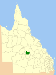 Location within Queensland | |||||||||||||||
| Population | 1,818 (2006 census)[1] | ||||||||||||||
| • Density | 0.21519/km2 (0.55734/sq mi) | ||||||||||||||
| Established | 1892 | ||||||||||||||
| Area | 8,448.4 km2 (3,261.9 sq mi) | ||||||||||||||
| Council seat | Barcaldine | ||||||||||||||
|
| |||||||||||||||
| Website | Shire of Barcaldine | ||||||||||||||
| |||||||||||||||
The Shire of Barcaldine was a local government area located in central Queensland and headquartered in the town of Barcaldine. It covered an area of 8,448.4 square kilometres (3,261.9 sq mi), and existed as a local government entity from 1892 until 2008, when it amalgamated with the Shires of Aramac and Jericho to form the Barcaldine Region.
Major industries in the area are wool and grazing.
History
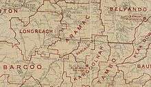
Kargoolnah Division was created on 11 November 1879 as one of 74 divisions around Queensland under the Divisional Boards Act 1879, and included the areas of Blackall, Tambo and Barcaldine as well as parts of Jericho. On 3 September 1892, a new Barcaldine Division was proclaimed and excised from Kargoolnah.
With the passage of the Local Authorities Act 1902, Barcaldine Division became Shire of Barcaldine on 31 March 1903. On 15 March 2008, under the Local Government (Reform Implementation) Act 2007 passed by the Parliament of Queensland on 10 August 2007, the Shire of Barcaldine merged with the Shires of Aramac and Jericho to form the Barcaldine Region.[2]
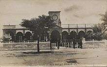
The Barcaldine Shire Hall built it in 1912 is now listed on the Queensland Heritage Register.[3]
Towns and localities
The Shire of Barcaldine included the following settlements:
- Barcaldine
- Barcaldine Downs
- Grant
- Narbethong
- Patrick
Chairmen
- 1927: Robert Francis Lyons [4]
Population
| Year | Population |
|---|---|
| 1933 | 2,612 |
| 1947 | 2,147 |
| 1954 | 2,200 |
| 1961 | 2,384 |
| 1966 | 2,282 |
| 1971 | 1,868 |
| 1976 | 1,780 |
| 1981 | 1,783 |
| 1986 | 1,779 |
| 1991 | 1,813 |
| 1996 | 1,850 |
| 2001 | 1,773 |
| 2006 | 1,818 |
References
- ↑ Australian Bureau of Statistics (25 October 2007). "Barcaldine (S) (Local Government Area)". 2006 Census QuickStats. Retrieved 17 September 2009.
- ↑ "Agency ID11031, Barcaldine Regional Council". Queensland State Archives. Retrieved 21 September 2013.
- ↑ "Barcaldine Shire Hall & Offices (entry 601274)". Queensland Heritage Register. Queensland Heritage Council. Retrieved 28 March 2014.
- ↑ Pugh, Theophilus Parsons (1927). Pugh's Almanac for 1927. Retrieved 13 June 2014.
External links
- "Barcaldine and Barcaldine Shire". Queensland Places. Centre for the Government of Queensland, University of Queensland.