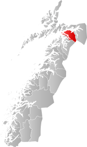
Ballangen
| Ballangen kommune | |||
|---|---|---|---|
| Municipality | |||
| |||
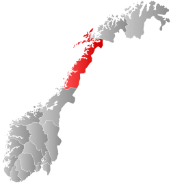
 Ballangen within Nordland | |||
| Coordinates: 68°18′23″N 16°44′39″E / 68.30639°N 16.74417°ECoordinates: 68°18′23″N 16°44′39″E / 68.30639°N 16.74417°E | |||
| Country | Norway | ||
| County | Nordland | ||
| District | Ofoten | ||
| Established | 1925 | ||
| Administrative centre | Ballangen | ||
| Government | |||
| • Mayor (2015) | Per Kristian Arntzen (Sp) | ||
| Area | |||
| • Total | 932.21 km2 (359.93 sq mi) | ||
| • Land | 846.69 km2 (326.91 sq mi) | ||
| • Water | 85.52 km2 (33.02 sq mi) | ||
| Area rank | #119 in Norway | ||
| Population (2017) | |||
| • Total | 2,554 | ||
| • Rank | #289 in Norway | ||
| • Density | 3.0/km2 (8/sq mi) | ||
| • Change (10 years) | -4.8% | ||
| Demonym(s) | Ballangsværing not found in citation[1] | ||
| Time zone | UTC+01:00 (CET) | ||
| • Summer (DST) | UTC+02:00 (CEST) | ||
| ISO 3166 code | NO-1854 | ||
| Official language form | Bokmål | ||
| Website |
ballangen | ||
Ballangen (Northern Sami: Bálák) is a municipality in Nordland county, Norway. It is part of the traditional district of Ofoten. The administrative centre of the municipality is the village of Ballangen. Other villages include Bjørkåsen, Kjeldebotn, Kobbvika, and Skarstad.
The municipality borders Narvik to the east and Tysfjord to the south, and has a short border with Sweden to the southeast. Ballangen is situated on the southern shore of Ofotfjorden. Ballangen also includes the long and narrow Efjorden, just south of the much larger Ofotfjorden. Its immediate surroundings are dominated by fjords, mountains, and forests. Ballangen relies on the neighbouring Narvik as its economic base.
The 932-square-kilometre (360 sq mi) municipality is the 119th largest by area out of the 422 municipalities in Norway. Ballangen is the 289th most populous municipality in Norway with a population of 2,554. The municipality's population density is 3 inhabitants per square kilometre (7.8/sq mi) and its population has decreased by 4.8% over the last decade.[2]
The village of Ballangen lies along the southern shore of the Ofotfjorden along the European route E06 highway. The highway crosses the Efjord Bridges on its way to Ballangen and then on again to the town of Narvik. The 0.93-square-kilometre (230-acre) village of Ballangen has a population (2013) of 827. The population density is 889 inhabitants per square kilometre (2,300/sq mi).[3]
General information
The municipality of Ballangen was established on 1 July 1925 when it was separated from the large municipality of Evenes. The new municipality encompassed all of Evenes located south of the Ofotfjorden. Initially, Ballangen had 3,270 residents. On 1 January 1962, the southern part of Lødingen (the island of Barøya and the area surrounding the Efjorden; population: 433) was transferred from to Ballangen. The borders have not changed since.[4]
In 2017, the municipality decided to merge with the neighboring municipalities of Narvik and the eastern half of Tysfjord to form a new, larger municipality of Narvik effective 1 January 2020.[5]
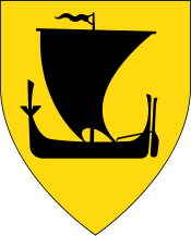
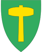
Coat-of-arms
The coat-of-arms is from modern times; they were granted on 18 July 1980. The arms show a gold hammer on a green background. It was chosen as a symbol to represent the mining in the municipality. There used to be copper mines in the municipality. The green background symbolizes agriculture.[6]
Name
The Old Norse form of the name was Bagangr. The meaning of the first element is not known and the last element is angr, which means "fjord".[7][8][9]
Churches
The Church of Norway has one parish (sokn) within the municipality of Ballangen. It is part of the Ofoten prosti (deanery) in the Diocese of Sør-Hålogaland.
| Parish (Sokn) | Church Name | Location of the Church | Year Built |
|---|---|---|---|
| Ballangen | Ballangen Church | Ballangen | 1923 |
| Efjord Chapel | Kobbvika | 1985 | |
| Kjeldebotn Church | Kjeldebotn | 1956 |
History
The first person living in Ballangen was Lodve Lange (Lodve the long), who is mentioned in Heimskringla as being one of King Olav Tryggvason's most trusted warriors, and being placed near the king in the famous ship Ormen Lange (long serpent).[10] Lodve probably participated in the Battle of Svolder in the year 1000, and might have been killed there. He lived at Saltvik, which is near the fjord, east of today's village of Ballangen.[10]
There is a long history of mining in Ballangen, starting from the 17th century. Over the years as many as 36 mines have been operated in Ballangen, including minerals like copper, nickel and iron, zinc, manganese, and lead, but the most serious mining started in 1911 with Bjørkåsen Gruver mining mostly pyrite. Mining for nickel and olivine continued until 2002. There is also a dolomite quarry in Ballangen. Ballangen is the main agricultural municipality in the Ofoten region.[9] The Ballangen Museum is located in the village of Bjørkåsen in the municipality and presents the local mining history.[11]
Ballangen has the dubious distinction of having Norway's highest rate of sick leave from work,[12] probably due to the high number of people who worked in the mines there, and related environmental effects.[13]
Government
All municipalities in Norway, including Ballangen, are responsible for primary education (through 10th grade), outpatient health services, senior citizen services, unemployment and other social services, zoning, economic development, and municipal roads. The municipality is governed by a municipal council of elected representatives, which in turn elect a mayor.
Municipal council
The municipal council (Kommunestyre) of Ballangen is made up of 17 representatives that are elected to four year terms. Currently, the party breakdown is as follows:[14]
| Party Name | Name in Norwegian | Number of representatives | |
|---|---|---|---|
| Labour Party | Arbeiderpartiet | 5 | |
| Progress Party | Fremskrittspartiet | 2 | |
| Conservative Party | Høyre | 2 | |
| Christian Democratic Party | Kristelig Folkeparti | 1 | |
| Centre Party | Senterpartiet | 7 | |
| Total number of members: | 17 | ||
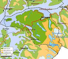
Geography
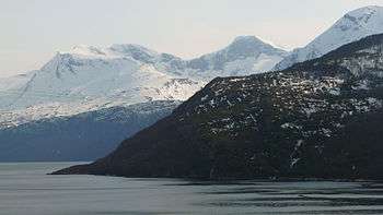
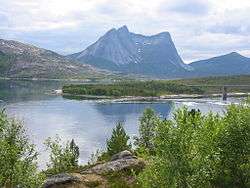
The Efjorden area is dominated by large slopes of bare rock with a narrow green area of vegetation near the fjord. The obelisk-like mountain, Stetind, nearby is dominated by the same, dark blue-grey rock, which contrasts with the clear water in the fjord where the sand banks can be seen just below the surface. Climbers and hikers are often tempted to test their skills on the rocky slopes. The large Frostisen glacier is located in the southeastern part of the municipality.
In the east, Ballangen borders on lake Siiddašjávri which it shares with Sweden. Siiddašjávri is the 14th largest lake which lies in or partially in Norway. Other lakes in the municipality include Børsvatnet, Geitvatnet, Hjertvatnet, Kjelvatnet, Langvatnet, Melkevatnet, Røvatnet, Søre Bukkevatnet, and Storvatnet.
The island of Barøya sits near the entrances to the Ofotfjorden and Efjorden. The Barøy Lighthouse sits on the northern edge of the island.
Notable residents
- Anni-Frid Lyngstad, singer in the group ABBA, was born in Ballangen
- Geir Bratland, of Apoptygma Berzerk, Dimmu Borgir, God Seed, The Kovenant and Satyricon (band) was born and raised in Ballangen
Sister cities
References
- ↑ "Navn på steder og personer: Innbyggjarnamn" (in Norwegian). Språkrådet. Retrieved 2015-12-01.
- ↑ Statistisk sentralbyrå (2017). "Table: 06913: Population 1 January and population changes during the calendar year (M)" (in Norwegian). Retrieved 2017-09-09.
- ↑ Statistisk sentralbyrå (1 January 2013). "Urban settlements. Population and area, by municipality".
- ↑ Jukvam, Dag (1999). "Historisk oversikt over endringer i kommune- og fylkesinndelingen" (PDF) (in Norwegian). Statistisk sentralbyrå. Archived (PDF) from the original on 7 April 2004.
- ↑ Karlsen, Tone Anita (2017-08-22). "Ny Narvik tar form". Harstad Tidende (in Norwegian). Retrieved 2017-09-10.
- ↑ Norske Kommunevåpen (1990). "Civic heraldry of Norway/Norske Kommunevåpen: Ballangen". Archived from the original on 8 June 2015.
- ↑ Unger, Carl Rikard (1896). Sproglig-historiske studier (in Norwegian). Kristiania, Norge: H. Aschehoug & Co. p. 77. Retrieved 18 November 2008.
- ↑ Rygh, Oluf (1905). Norske gaardnavne: Nordlands amt (in Norwegian) (16 ed.). Kristiania, Norge: W. C. Fabritius & sønners bogtrikkeri. p. 293.
- 1 2 Store norske leksikon. "Ballangen" (in Norwegian). Retrieved 22 May 2012.
- 1 2 "Lodve Lange". Fylkesleksikon. Nordland fylkeskommune. 15 December 2010. Archived from the original on 15 August 2017.
- ↑ "Ballangen Museum". Museum Nord. Retrieved September 13, 2018.
- ↑ Taylor, Gerald (13 August 2017). "Ballangen, in Ofoten, enjoys dubious distinction of having Norway's highest absence from work due to sickness". Norway Today. Archived from the original on 15 August 2017.
- ↑ Kelion, Leo (15 August 2017). "Record-sized data centre planned inside Arctic Circle". BBC News.
- ↑ "Table: 04813: Members of the local councils, by party/electoral list at the Municipal Council election (M)" (in Norwegian). Statistics Norway. 2015.
External links
- Municipal fact sheet from Statistics Norway (in Norwegian)
| Wikimedia Commons has media related to Ballangen. |

- Some nice pictures from Ballangen
- Ballangen Camping
| |||||||||||||||||
| |||||||||||||||||