Guvåg
| Guvåg | |
|---|---|
| Village | |
 | |
 Guvåg Location in Nordland  Guvåg Guvåg (Norway) | |
| Coordinates: 68°39′51″N 14°45′30″E / 68.66417°N 14.75833°ECoordinates: 68°39′51″N 14°45′30″E / 68.66417°N 14.75833°E | |
| Country | Norway |
| Region | Northern Norway |
| County | Nordland |
| District | Vesterålen |
| Municipality | Bø |
| Elevation[1] | 6 m (20 ft) |
| Time zone | UTC+01:00 (CET) |
| • Summer (DST) | UTC+02:00 (CEST) |
| Post Code | 8475 Straumsjøen |
Guvåg is a village in the municipality of Bø in Nordland county, Norway.
Geography
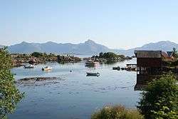
Guvåg lies on the shore of Eidsfjord between the mouth of Jørnfjord to the east and Hellfjord to the west. Many skerries lie in the sea near Guvåg. Ørntuva Hill (247 meters or 810 feet) rises immediately north of Guvåg, with the Breitinden Plateau (598 meters or 1,962 feet) rising beyond that.[2][3]
Norwegian County Road 913, which terminates in Guvåg, runs north from the village, connecting it to other settlements on Langøya.[4]
References
- ↑ "Guvåg, Bø (Nordland)" (in Norwegian). yr.no. Retrieved February 26, 2017.
- ↑ Kostial, Andrea, & Tobias Kostial. 2016. Lofoten und Vesteralen. 50 Touren im Reich der Mitternachtssonne. Munich: Bergverlag Rother, pp. 156–157.
- ↑ "Norgeskart" (in Norwegian). Retrieved 2017-02-06.
- ↑ Vegliste 2016: Fylkes- og kommunale veger. Nordland. 2016. Bodø: Statens vegvesen Region nord, p. 30. Archived 2017-03-08 at the Wayback Machine.
This article is issued from
Wikipedia.
The text is licensed under Creative Commons - Attribution - Sharealike.
Additional terms may apply for the media files.