Straume, Nordland
| Straume | |
|---|---|
| Village | |
 View of the village | |
 Straume Location in Nordland  Straume Straume (Norway) | |
| Coordinates: 68°41′20″N 14°28′17″E / 68.68889°N 14.47139°ECoordinates: 68°41′20″N 14°28′17″E / 68.68889°N 14.47139°E | |
| Country | Norway |
| Region | Northern Norway |
| County | Nordland |
| District | Vesterålen |
| Municipality | Bø |
| Area[1] | |
| • Total | 0.43 km2 (0.17 sq mi) |
| Elevation[2] | 7 m (23 ft) |
| Population (2013)[1] | |
| • Total | 309 |
| • Density | 719/km2 (1,860/sq mi) |
| Time zone | UTC+01:00 (CET) |
| • Summer (DST) | UTC+02:00 (CEST) |
| Post Code | 8475 Straumsjøen |
Straume is the administrative centre of the municipality of Bø in Nordland county, Norway. It is located on the island of Langøya in the Vesterålen archipelago. The village is located about 10 kilometres (6.2 mi) from the villages of Bø (to the south) and Eide (to the north), in the west central part of the municipality. The 0.43-square-kilometre (110-acre) village has a population (2013) of 309. The population density of the village is 719 inhabitants per square kilometre (1,860/sq mi).[1][3]
Straume is the junction of county roads 820, 901, and 903. The Straume Nature Reserve lies south of the village.[4]
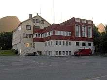
The municipal administration building in Straume
References
- 1 2 3 Statistisk sentralbyrå (1 January 2013). "Urban settlements. Population and area, by municipality".
- ↑ "Straume" (in Norwegian). yr.no. Retrieved 2012-07-29.
- ↑ Store norske leksikon. "Straume – i Bø" (in Norwegian). Retrieved 2012-07-29.
- ↑ Mijlø-direktoratet: Straume.
This article is issued from
Wikipedia.
The text is licensed under Creative Commons - Attribution - Sharealike.
Additional terms may apply for the media files.