Alma, Quebec
| Alma | ||
|---|---|---|
| Town | ||
 | ||
| ||
| Motto(s): La ville de l'hospitalité | ||
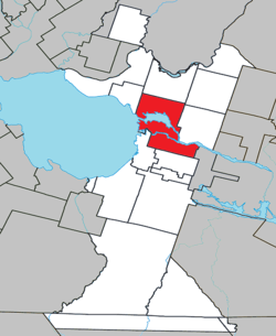 Location within Lac-Saint-Jean-Est RCM. | ||
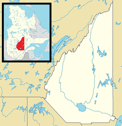 Alma Location in Saguenay–Lac-Saint-Jean Quebec. | ||
| Coordinates: 48°33′N 71°39′W / 48.550°N 71.650°WCoordinates: 48°33′N 71°39′W / 48.550°N 71.650°W[1] | ||
| Country |
| |
| Province |
| |
| Region | Saguenay–Lac-Saint-Jean | |
| RCM | Lac-Saint-Jean-Est | |
| Amalgamation | 1962 (of Isle-Maligne, Naudville, Riverbend and St-Joseph d'Alma.) | |
| Constituted | February 21, 2001 (amalgamation with Delisle) | |
| Government[2] | ||
| • Mayor | Marc Asselin | |
| • Federal riding | Lac-Saint-Jean | |
| • Prov. riding | Lac-Saint-Jean | |
| Area[2][3] | ||
| • Town | 230.30 km2 (88.92 sq mi) | |
| • Land | 195.59 km2 (75.52 sq mi) | |
| • Urban[4] | 41.10 km2 (15.87 sq mi) | |
| • Metro[5] | 340.35 km2 (131.41 sq mi) | |
| Population (2011)[3] | ||
| • Town | 30,904 | |
| • Density | 158.0/km2 (409/sq mi) | |
| • Urban[4] | 26,016 | |
| • Urban density | 633.0/km2 (1,639/sq mi) | |
| • Metro[5] | 33,018 | |
| • Metro density | 97.0/km2 (251/sq mi) | |
| • Pop 2006-2011 |
| |
| • Dwellings | 13,884 | |
| Time zone | UTC−5 (EST) | |
| • Summer (DST) | UTC−4 (EDT) | |
| Postal code(s) | G8B, G8C & G8E | |
| Area code(s) | 418 and 581 | |
| Highways |
| |
| Telephone Exchanges | 212, 321, 480-2, 487, 662, 668-9, 719, 720, 769 | |
| GNBC Code | EFHQD | |
| NTS Map | 022D12 | |
| Website |
www | |
.svg.png)
Alma (2011 Town population: 30,904; CA Population 33,018; UA Population 26,016) is a town in the Canadian province of Quebec.
Geography
Alma is located on the southeast coast of Lac Saint-Jean where it flows into the Saguenay River, in the Saguenay–Lac-Saint-Jean region of Quebec, Canada, approximately 175 km north of Quebec City. Alma is the seat of Lac-Saint-Jean-Est Regional County Municipality. Alma is the second city in population in the Saguenay-Lac-Saint-Jean region after the city of Saguenay.
Alma is the seat of the judicial district of Alma.[6]
History
The present town of Alma was formed in 1962 from the merging of four villages: Isle-Maligne, Naudville, Riverbend and St-Joseph d'Alma. The oldest of the villages, St-Joseph-d'Alma, was founded in 1867 by Damase Boulanger. The area became an important industrial centre during the 1920s and 1930s with the construction of a hydro-electrical power station on the Grande-Décharge River, a paper mill (Price) and an aluminum smelting plant (Alcan), all of which are still in activity today.
In 2002, Alma merged with the Municipality of Delisle.
Demographics
Population trend:[7]
- Population in 2011: 30,904 (2006 to 2011 population change: 3%)
- Population in 2006: 29,998
- Population total in 2001: 30,126
- Alma (ville): 25,918
- Delisle (municipality): 4,208
- Population in 1996:
- Alma (ville): 26,127
- Delisle (municipality): 4,256
- Population in 1991:
- Alma (ville): 25,910
- Delisle (municipality): 4,281
Private dwellings occupied by usual residents: 13324 (total dwellings: 13884)
Mother tongue:[8]
- English as first language: 0.5%
- French as first language: 98.5%
- English and French as first language: 0.1%
- Other as first language: 0.9%
| Visible minority and Aboriginal population (Canada 2006 Census) | |||
|---|---|---|---|
| Population group | Population | % of total population | |
| White | 29,025 | 97.7% | |
| Visible minority group Source:[9] | South Asian | 0 | 0% |
| Chinese | 45 | 0.2% | |
| Black | 40 | 0.1% | |
| Filipino | 0 | 0% | |
| Latin American | 20 | 0.1% | |
| Arab | 15 | 0.1% | |
| Southeast Asian | 60 | 0.2% | |
| West Asian | 0 | 0% | |
| Korean | 0 | 0% | |
| Japanese | 10 | 0% | |
| Visible minority, n.i.e. | 0 | 0% | |
| Multiple visible minority | 0 | 0% | |
| Total visible minority population | 200 | 0.7% | |
| Aboriginal group Source:[10] | First Nations | 125 | 0.4% |
| Métis | 335 | 1.1% | |
| Inuit | 0 | 0% | |
| Aboriginal, n.i.e. | 10 | 0% | |
| Multiple Aboriginal identity | 0 | 0% | |
| Total Aboriginal population | 480 | 1.6% | |
| Total population | 29,705 | 100% | |
Transportation
Alma is serviced by the Alma Airport, located 4.1 km to the south of the town.
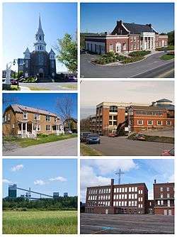
Image gallery
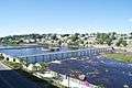 Petite-Décharge
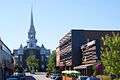 Downtown Alma
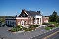 Former Isle-Maligne town hall
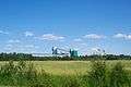 Rio Tinto Alcan aluminum smelter in Alma
Notable people
- Émilie Fortin Tremblay (1872-1949), one of the first white women to cross the Chilkoot on the way to the Yukon gold fields
- Mario Tremblay, hockey player and former coach of the Montreal Canadiens
- Marie-Lise Pilote, comedian
- Michel Côté, comedian
- Guy Cloutier, producer and artist manager
- Lucien Bouchard, former premier of Québec
- Guillaume Desbiens, hockey player
- Charles Hudon, hockey player for the Montreal Canadiens
- Pierre Lapointe, Singer
- André Bouchard, homme d'affaire et bâtisseur
See also
References
- ↑ Reference number 1013 of the Commission de toponymie du Québec (in French)
- 1 2 Ministère des Affaires municipales, des Régions et de l'Occupation du territoire - Répertoire des municipalités: Alma Archived 2012-01-15 at the Wayback Machine.
- 1 2 "Alma census profile". 2011 Census data. Statistics Canada. Retrieved 2012-05-24.
- 1 2 "Alma (Population centre) community profile". 2011 Census data. Statistics Canada. Retrieved 2012-05-24.
- 1 2 "Alma (Census agglomeration) community profile". 2011 Census data. Statistics Canada. Retrieved 2012-05-24. The census agglomeration consists of Alma and Saint-Nazaire. In the 2006 census, the census agglomeration had also included Saint-Henri-de-Taillon.
- ↑ Territorial Division Act. Revised Statutes of Quebec D-11.
- ↑ Statistics Canada: 1996, 2001, 2006, 2011 census
- ↑ "Alma community profile". 2006 Census data. Statistics Canada. Retrieved 2010-11-10.
- ↑ , Community Profiles from the 2006 Census, Statistics Canada - Census Subdivision
- ↑ , Aboriginal Population Profile from the 2006 Census, Statistics Canada - Census Subdivision
External links
![]()
- (in French) Ville d'Alma
Adjacent Municipal Subdivisions | |
|---|---|
| Cities | |
|---|---|
| Municipalities | |
| Parishes | |
| Villages | |
| Unorganized territories | |
| |