Lambton, Quebec
| Lambton | |
|---|---|
| Municipality | |
 | |
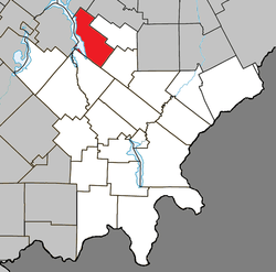 Location within Le Granit RCM | |
 Lambton Location in southern Quebec | |
| Coordinates: 45°50′N 71°05′W / 45.83°N 71.08°WCoordinates: 45°50′N 71°05′W / 45.83°N 71.08°W[1] | |
| Country |
|
| Province |
|
| Region | Estrie |
| RCM | Le Granit |
| Constituted | December 23, 1976 |
| Government[2] | |
| • Mayor | Ghislain Bolduc |
| • Federal riding | Mégantic—L'Érable |
| • Prov. riding | Mégantic |
| Area[2][3] | |
| • Total | 124.70 km2 (48.15 sq mi) |
| • Land | 108.34 km2 (41.83 sq mi) |
| Population (2011)[3] | |
| • Total | 1,584 |
| • Density | 14.6/km2 (38/sq mi) |
| • Pop 2006-2011 |
|
| • Dwellings | 1,216 |
| Time zone | UTC−5 (EST) |
| • Summer (DST) | UTC−4 (EDT) |
| Postal code(s) | G0M 1H0 |
| Area code(s) | 418 and 581 |
| Highways |
|
| Website |
www |
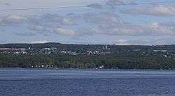
Lambton is a municipality of about 1600 people in Le Granit Regional County Municipality in the Estrie region of Quebec, Canada.
Lambton is mostly rural and agricultural area with some business on the two main roads in town.
Transportation
The main roads connecting Lambton are Route 108 and Route 263.
References
External links

Places adjacent to Lambton, Quebec | |
|---|---|
| Cities | |
|---|---|
| Municipalities | |
| Parishes | |
| Townships | |
| |
This article is issued from
Wikipedia.
The text is licensed under Creative Commons - Attribution - Sharealike.
Additional terms may apply for the media files.