Quebec Route 366
| ||||
|---|---|---|---|---|
 | ||||
| Route information | ||||
| Maintained by Transports Québec | ||||
| Length | 90.0 km[1] (55.9 mi) | |||
| Major junctions | ||||
| West end |
| |||
|
| ||||
| East end |
| |||
| Location | ||||
| Major cities | Ladysmith, Lac-des-Loups, La Pêche (Ste-Cécile-de-Masham), Wakefield, Val-des-Monts (Saint-Pierre-de-Wakefield & Perkins), Gatineau | |||
| Highway system | ||||
| ||||

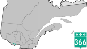
Route 366 is a secondary highway in the Outaouais region of Quebec. It runs from Route 301 near Creemorne in the Pontiac to Route 148 in the city of Gatineau.
The section west of Lac-des-Loups is mostly unpaved. After skirting the northern boundary of Gatineau Park, the highway is briefly concurrent with Route 105 before continuing eastward. Near Val-des-Monts township it overlaps Route 307 for 7 km (4 mi) before veering south towards Gatineau and its terminus with Route 148.
In 2011, Google Maps mislabeled Quebec Route 366 as running concurrent with the entire length of U.S. Route 30 from Astoria, Oregon to Atlantic City, New Jersey.[2]
Municipalities along Route 366
- Ladysmith
- Lac-des-Loups
- La Pêche (Ste-Cécile-de-Masham)
- Wakefield
- Val-des-Monts (Perkins)
- Gatineau
See also
References
- ↑ Ministère des transports, "Distances routières", page (?), Les Publications du Québec, 2005
- ↑ "Route 30 Mislabeled On Google Maps". KYW-TV. June 30, 2011. Retrieved April 5, 2012.
External links
- Official Transports Quebec Road Map Network (in French)
This article is issued from
Wikipedia.
The text is licensed under Creative Commons - Attribution - Sharealike.
Additional terms may apply for the media files.