Invermere
| Invermere | |
|---|---|
| District municipality | |
| District of Invermere[1] | |
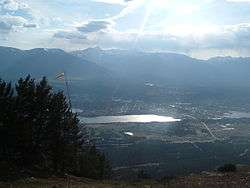 Invermere, British Columbia, with Mount Nelson in the distance | |
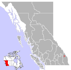 Location of Invermere, British Columbia | |
| Coordinates: 50°30′30″N 116°01′49″W / 50.50833°N 116.03028°W | |
| Country | Canada |
| Province | British Columbia |
| Region | East Kootenay |
| Incorporated | 1951 |
| Government | |
| • Mayor | Gerry Taft |
| • Governing body | Invermere Council |
| • MP | Wayne Stetski |
| • MLA | Norm Macdonald |
| Area[2] | |
| • Land | 10.73 km2 (4.14 sq mi) |
| Elevation | 859 m (2,818 ft) |
| Population (2016)[2] | |
| • Total | 3,391 |
| • Density | 315.9/km2 (818/sq mi) |
| Time zone | UTC-7 (Mountain Standard (MST)) |
| • Summer (DST) | UTC-6 (Mountain Daylight (MDT)) |
| Postal code span | V0A 1K0, V0A 1K7 |
| Area code(s) | 250 / 778 / 236 |
| Highways |
|
| Waterways | Columbia River, Windermere Lake |
| Website | Town of Invermere |
Invermere is a community in eastern British Columbia, Canada, near the border of Alberta. It is the hub of the Columbia Valley between Golden to the north and Cranbrook to the south. Invermere sits on the northwest shore of Windermere Lake and is a popular summer destination for visitors and second home owners from Calgary.
Geography
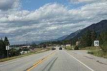
Invermere is located 14 kilometres (8.7 mi) south of Radium, and 104 kilometres (65 mi) south of Golden and 102 kilometres (63 mi) from the Trans-Canada Highway. Invermere is also 37 kilometres (23 mi) north of Fairmont Hot Springs, 60 kilometres (37 mi) north of Canal Flats, 128 kilometres (80 mi) north of Fort Steele, 130 kilometres (81 mi) north of Kimberley, and 144 kilometres (89 mi) north of the hub of Cranbrook and the Crowsnest Highway. Invermere is situated within the Columbia River Wetlands, North America's largest intact wetland and a Ramsar-designated site. Located in the Rocky Mountain Trench, Invermere is 17.5 kilometres (10.9 mi) from Kootenay National Park, and is near the Purcell Wilderness Conservancy.
Climate
Invermere's climate is characterized by warm summers and cool winters. The Rocky Mountains to the east shield Invermere from the Arctic air in winter, although extreme cold spells do occur on occasion. Spring arrives earlier than on the prairies to the east of the Rocky Mountains. Although warm, summers are variable, with weather alternating between hot, dry spells and cool, showery periods.
Sports and recreation
- Hockey
The Columbia Valley Rockies play in Invermere. Former New York Islanders and University of Denver goaltender Wade Dubielewicz was born in Invermere.
| Club | League | Sport | Venue | Established | Championships |
|---|---|---|---|---|---|
| Columbia Valley Rockies | KIJHL | Ice hockey | Eddie Mountain Memorial Arena | 1978 | 4 |
- Skiing
- Panorama Mountain Village lies about 30 minutes west.
- Fairmont Hot Springs Resort ski area lies 25 minutes south.
- Kimberley Alpine Resort is about 1 hour south in Kimberley.
- Kicking Horse Mountain Resort is about 1.5 hours north of Invermere in Golden, British Columbia
- Skating
The longest ice skating trail in the world can be found on the Lake Windermere Whiteway. The naturally frozen trail measures 29.98 kilometres (18.63 mi).[3]
- Golfing
Invermere is a major centre for golf.
- Copper Point Golf Club is a newer golf course about 2 kilometres (1.2 mi) east of Invermere along Highway 95/93.
- Eagle Ranch Golf Course is located 3 kilometres (1.9 mi) northeast of Invermere, also along Highway 93/95 and was rated 4.5/5.0 stars by Golf Digest.
- Greywolf Golf Course is located in Panorama Mountain Village is about 18 kilometres (11 mi) west of Invermere, along the Toby Creek canyon.
- The Resort Course and Springs Course at Radium Resort, Radium Hot Springs are very popular.
- Mountainside, Creekside, and Riverside golf courses are located in Fairmont Hot Springs, 20 minutes south of Invermere.
- Edgewater Hill Top Par 3 is located in Edgewater, 20 minutes north of Invermere.
- Setekwa Golf Course is located about 7 kilometres (4.3 mi) north of Invermere on Highway 93/95.
- Windermere Valley Golf Course is located approximately 4 kilometres (2.5 mi) south of Invermere, by the town of Windermere
- Gliding and soaring
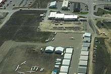
The Invermere Airport is home to the non-profit Canadian Rockies Soaring Club. The club is active during the summer months, when it welcomes dozens of student pilots and private owners. The Invermere Soaring Centre is a separate commercial operation which provides aerotowing services and glider rides to the general public.
- Canadian Rockies Soaring Club
- Invermere Soaring Centre
The local area is also a popular destination for other non-motorized forms of flying including hang-gliding and paragliding. There are designated launch sites at nearby Mount Swansea.
- Curling
The Valley is host to the biggest outdoor bonspiel in Canada every January. The spiel is held on the frozen Windermere Lake. The curling club is also host to many leagues and bonspiels throughout the season.
- Hot springs
Hot springs are numerous in the area, with the major developed ones being Fairmont and Radium Hot Springs; the latter is located inside Kootenay National Park.
Less developed 'wilderness' hot springs can be found in the southern Columbia Valley, in Whiteswan Lake Provincial Park.[4] Lussier Hot Springs is located 74 kilometres (46 mi) south of Invermere and can be accessed from the Whiteswan Forestry Road. Ram Creek Warm Springs, a less visited and cooler natural spring, can also be accessed along the same route.
Media
Invermere is home to one newspaper, the Columbia Valley Pioneer. On July 1, 2017, the "Pioneer" (founded in 2004) and the Invermere Valley Echo (founded in 1956) merged to one paper retaining the Columbia Valley Pioneer designation. The "Pioneer" serves the Columbia Valley region, from Spillimacheen in the north to Canal Flats in the south and is published once a week, every Thursday.
Notable people
- Wade Dubielewicz - Ice hockey player and coach
- Christine Keshen - Curler
- Patrick Morrow - Photographer
- Benjamin Thomsen - Professional skier
- Brian Williams - Sportscaster
References
- ↑ "British Columbia Regional Districts, Municipalities, Corporate Name, Date of Incorporation and Postal Address" (XLS). British Columbia Ministry of Communities, Sport and Cultural Development. Archived from the original on July 13, 2014. Retrieved November 2, 2014.
- 1 2 "Population and dwelling counts, for Canada, provinces and territories, and census subdivisions (municipalities), 2016 and 2011 censuses – 100% data (British Columbia)". Statistics Canada. August 28, 2017. Retrieved December 31, 2017.
- ↑ "Longest ice skating trail". www.guinnessworldrecords.com. Retrieved July 29, 2014.
- ↑ "Whiteswan Lake Provincial Park website".
External links
- District of Invermere – District Website
- Invermere.com / ColumbiaValley.com - Business Directory, Local Online Newspaper, Live Webcams
- Invermere.ca
| Subdivisions |  | |
|---|---|---|
| Communities | ||
| Metro areas and agglomerations | ||
| District municipalities |
| |
| ||
Coordinates: 50°30′30″N 116°1′49″W / 50.50833°N 116.03028°W