West Kelowna
| West Kelowna Westside (2007–2009) | |
|---|---|
| City | |
| City of West Kelowna[1] | |
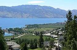 West Kelowna as seen from Mount Boucherie, with Okanagan Lake and Okanagan Mountain Provincial Park in the background | |
 West Kelowna Location of West Kelowna in British Columbia | |
| Coordinates: 49°51′45″N 119°35′00″W / 49.86250°N 119.58333°W | |
| Country |
|
| Province |
|
| Region | Okanagan |
| Regional district | Central Okanagan |
| Incorporated (district municipality) | December 6, 2007 |
| Name change | January 30, 2009 |
| Incorporated (city)[2] | June 26, 2015 |
| Government | |
| • Mayor | Doug Findlater |
| Area[3] | |
| • Total | 123.53 km2 (47.70 sq mi) |
| Elevation | 484 m (1,588 ft) |
| Population (2016)[3] | |
| • Total | 32,655 |
| • Density | 264.4/km2 (685/sq mi) |
| • 2016 pop. est.[4] | 34,930 |
| Time zone | UTC-8 (PST) |
| Forward sortation area | V1Z, V4T |
| Highways | 97, 97C |
| Waterways | Okanagan Lake |
| Website | http://www.westkelownacity.ca/ |
West Kelowna is a city in British Columbia's Okanagan Valley. The city encompasses several distinct communities, including historic Westbank, Glenrosa, Smith Creek, Shannon Lake, Rose Valley, West Kelowna Estates, Casa Loma, and Lakeview Heights. West Kelowna had a population of 32,655 as of the 2016 census.[3]
West Kelowna was incorporated on December 6, 2007, as Westside District Municipality, so named because it was the name of the regional district rural electoral area at the time. On January 30, 2009, the district was renamed West Kelowna. The municipality was reclassified as the City of West Kelowna on June 26, 2015.[2] The general area is also sometimes referred to as Westbank.[5]
History
Westside District Municipality was established on December 6, 2007, following a referendum in June 16, 2007, in which Westside residents voted to incorporate by a margin of 5,924 votes to 5,582.[6] The other choice was amalgamation with the City of Kelowna, with a previous ballot question offering the option of remaining unincorporated within the regional district's Westside electoral area.[7] The vote was strongly split along geographical lines, with voters from Westbank, Glenrosa, and other areas farther from the City of Kelowna voting to incorporate in larger numbers and voters living closer to Kelowna typically choosing amalgamation.
On November 15, 2008, Doug Findlater was elected the new mayor of West Kelowna.[8]
During the November 2008 civic election, Westside residents were also asked in a "Community Opinion Vote" to select a permanent name for the fledgling municipality.[9] The new name "West Kelowna", with 3,841 votes, was selected by a narrow margin over the closest contender, "Westbank", with 3,675 votes. The West Kelowna name was subsequently confirmed by the district council on December 9, 2008. The controversial new name became official on January 30, 2009, after the Government of British Columbia approved the change.[10]
Geography
The City of West Kelowna is located on the central western shores of Okanagan Lake and is the primary gateway to the Central Okanagan from the west via Highway 97C, the Okanagan Connector.
Neighbourhoods within the city's jurisdiction include Westbank, Gellatly, Glenrosa, Shannon Lake, and Smith Creek in the south, which comprise approximately half of the total population, along with several other communities in the north, including Casa Loma, West Kelowna Estates, Rose Valley, Lakeview Heights, Sunnyside, and South Boucherie. Many of these neighbourhoods, including Glenrosa, Westbank, Gellatly, Sunnyside, and Lakeview Heights have rich histories, some dating to the early to mid-19th century.
Bordering the City of West Kelowna are the District of Peachland, Central Okanagan West Electoral Area, and two self-governing reserves of the Westbank First Nation,[11] Tsinstikeptum 9 and Tsinstikeptum 10. Approximately 9,000 non-band members and 800 First Nation Westbank band members live on the reserves.[12]
Demographics
| Federal census population history | ||
|---|---|---|
| Year | Pop. | ±% |
| 2006 | 27,214 | — |
| 2011 | 30,892 | +13.5% |
| 2016 | 32,655 | +5.7% |
| Source: Statistics Canada[13][3] | ||
In the 2016 Census of Population conducted by Statistics Canada, the City of West Kelowna recorded a population of 32,655 living in 12,437 of its 13,190 total private dwellings, a change of 5.7% from its revised 2011 population of 30,902. With a land area of 123.53 km2 (47.70 sq mi), it had a population density of 264.3/km2 (684.7/sq mi) in 2016.[3]
Economy
Traditional shopping areas in West Kelowna are Westbank Centre, Lakeview Heights Shopping Centre, Boucherie Centre, and the West Kelowna Business Park, which offer a variety of retail outlets, cafes and restaurants, and tourist accommodations and attractions. The City of West Kelowna also boasts a scenic wine trail; nearly a dozen wineries with world renowned wines line the route. The City of West Kelowna also boasts a farm loop, featuring varied local agricultural products, and the Gellalty Bay multi-use corridor, which includes the CNR Wharf Aquatic Park.[14]
More than 1,600 business operate in West Kelowna,[15] including major employers such as Gorman Bros. Lumber and Mission Hill Family Estate Winery.
West Kelowna's business areas are also complemented by those in the Westbank First Nation, which include various retail shops, cafes, services, and tourist accommodations and attractions.
Education
West Kelowna is located within School District 23 Central Okanagan. Mount Boucherie Senior Secondary School serves grades 10 through 12, and is the only high school in the municipality.[16] West Kelowna has two middle schools, serving grades 7 through 9: Constable Neil Bruce Middle School[17] and Glenrosa Middle School.[18] There are nine elementary schools in the municipality: Hudson Road Elementary School,[19] Rose Valley Elementary School,[20] Chief Tomat Elementary School,[21] Shannon Lake Elementary School,[22] George Pringle Elementary School,[23] Glenrosa Elementary School,[24] Helen Gorman Elementary School, and Sensisyusten House of Learning.[25] Post-secondary educational opportunities are available in the nearby City of Kelowna, including two major public institutions: UBC Okanagan[26] and Okanagan College.[27]
Recreation and culture
The Mount Boucherie Community Centre includes the Royal LePage Place arena, home to the BCHL team the West Kelowna Warriors, and Jim Lind Arena for ice sport clubs such as hockey, figure skating, and ringette. The city has a lakefront walking trail alongside Gellatly Road and several swimming areas along Okanagan Lake, including Willow Beach. Johnson Bentley Memorial Aquatic Centre, in downtown Westbank, offers public swimming and recreational programs. Several community and regional parks are scattered throughout the municipality, offering soccer pitches, ball fields, children's play areas, and hiking trails. The award-winning Constable Neil Bruce Soccer Fields are also a popular recreational destination. The municipality also funds youth and seniors' centres in downtown Westbank. A community garden, pergola, and two off-leash dog parks are located in the Westbank Town Centre Park, off Hebert Road. Crystal Ski Resort[28] is located west of the municipality and is about a 15-minute drive from the downtown core. Telemark Cross Country Ski Club is located next to the ski resort.[29] There are two golf courses in the municipality: Shannon Lake Golf Course[30] and Two Eagles Golf Course.[31] Culturally, the area has no theatre or major art gallery, though a few smaller galleries sell works by local artists and potters.
References
- ↑ "British Columbia Regional Districts, Municipalities, Corporate Name, Date of Incorporation and Postal Address" (XLS). British Columbia Ministry of Communities, Sport and Cultural Development. Archived from the original on July 13, 2014. Retrieved November 2, 2014.
- 1 2 "Order in Council No. 357". Province of British Columbia. June 26, 2015. Retrieved July 1, 2015.
- 1 2 3 4 5 "Population and dwelling counts, for Canada, provinces and territories, and census subdivisions (municipalities), 2016 and 2011 censuses – 100% data (British Columbia)". Statistics Canada. February 8, 2017. Retrieved February 19, 2017.
- ↑ "Population Estimates, British Columbia and Sub-Provincial - BC Stats". www.bcstats.gov.bc.ca. Retrieved 2017-02-08.
- ↑ "West Kelowna Name Approved" (PDF). District of West Kelowna. Archived from the original (PDF) on February 20, 2009. Retrieved 2009-02-17.
- ↑ D. Brotherton (June 16, 2007). "Westsiders choose incorporation". Kelowna Daily Courier. Retrieved 2009-02-17.
- ↑ "Westside Governance Referendum" (PDF). BC Ministry of Community Services. Retrieved 2009-02-17.
- ↑ "Local Government 2008 Elections". CivicInfo BC. Retrieved 2009-02-17.
- ↑ "Local Government 2008 Elections (Referendum Question)". CivicInfo BC. Archived from the original on December 23, 2008. Retrieved 2009-02-17.
- ↑ R. Seymour (January 31, 2009). "Westside reborn as West Kelowna". Kelowna Daily Courier. Archived from the original on May 27, 2011. Retrieved February 17, 2009.
- ↑ "Westbank First Nation website". Wfn.ca. Retrieved January 1, 2012.
- ↑ "2008 WFN Economic Profile" (PDF). Westbank First Nation.
- ↑ "Census subdivision of West Kelowna, DM - British Columbia". Statistics Canada. April 1, 2011. Retrieved August 24, 2013.
- ↑ "West Kelowna Top 10 - Visit Westside". Visit Westside. Retrieved 2017-02-08.
- ↑ "Facts at a Glance | West Kelowna, BC - Official Website". www.districtofwestkelowna.ca. Retrieved 2017-02-08.
- ↑ "Mount Boucherie School website". Mbs.sd23.bc.ca. Retrieved January 1, 2012.
- ↑ "Constable Neil Bruce Middle School". Cnb.sd23.bc.ca. December 19, 2011. Retrieved January 1, 2012.
- ↑ Glenrosa Middle School.
- ↑ Hudson Road Elementary School,
- ↑ Rose Valley School,
- ↑ Chief Tomat Elementary School,
- ↑ "Shannon Lake Elementary School MarJok Elementary". Sle.sd23.bc.ca. Retrieved January 1, 2012.
- ↑ "George Pringle Elementary School". Gpe.sd23.bc.ca. Retrieved January 1, 2012.
- ↑ "Glenrosa Elementary School". Gre.sd23.bc.ca. December 7, 2011. Retrieved January 1, 2012.
- ↑ "Helen Gorman Elementary School". Hge.sd23.bc.ca. December 9, 2011. Retrieved January 1, 2012.
- ↑ "UBC Okanagan". Web.ubc.ca. Retrieved January 1, 2012.
- ↑ "Okanagan College". Okanagan.bc.ca. August 19, 2009. Retrieved January 1, 2012.
- ↑ "Crystal Ski Resort website". Crystalresort.com. Retrieved January 1, 2012.
- ↑ "Telemark Cross Country Ski Club website". Telemarkx-c.com. Retrieved January 1, 2012.
- ↑ Design by: Orion’s Web Design. "Shannon Lake Golf Course website". Shannonlakegolf.com. Retrieved January 1, 2012.
- ↑ "Two Eagles Golf Course website". Twoeaglesgolf.com. Retrieved January 1, 2012.
External links
| Communities |
|
|---|---|
| Electoral areas | |
| Education | |
| Transportation | |
| |
| Subdivisions |  | |
|---|---|---|
| Communities | ||
| Metro areas and agglomerations | ||
| District municipalities |
| |
| ||
Coordinates: 49°51′45″N 119°35′00″W / 49.86250°N 119.58333°W
Municipalities and communities of Okanagan, British Columbia, Canada | ||
|---|---|---|
| Cities |  | |
| Towns | ||
| Districts | ||
| Villages | ||
| Designated places |
| |
| Unincorporated communities | ||
| Indian reservations | ||
| Ghost towns | ||
| Footnotes | ‡This populated place also has portions in an adjacent region | |