Kimberley, British Columbia
| Kimberley | |
|---|---|
| City | |
| City of Kimberley | |
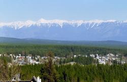 A view of the town of Kimberley | |
|
Motto(s): "Recordamur Omnium" (Latin) "We Are Mindful Of All" | |
 Kimberley Location of Kimberley in British Columbia | |
| Coordinates: 49°40′11″N 115°58′39″W / 49.66972°N 115.97750°WCoordinates: 49°40′11″N 115°58′39″W / 49.66972°N 115.97750°W | |
| Country | Canada |
| Province | British Columbia |
| Regional District | East Kootenay |
| Incorporation (city) | March 29, 1944[1] |
| Amalgamation | November 1, 1968[2] |
| Government | |
| • Mayor | Don McCormick |
| Area | |
| • Land | 60.62 km2 (23.41 sq mi) |
| Elevation | 1,120 m (3,670 ft) |
| Population (2016)[3] | |
| • Total | 7,425 |
| • Density | 1,020.4/km2 (2,643/sq mi) |
| Time zone | UTC-7 (MST) |
| Forward sortation area | V1A |
| Area code(s) | 250 / 778 / 236 |
| Highways |
|
| Website | http://www.kimberley.ca |
Kimberley is a city in southeast British Columbia, Canada along Highway 95A between the Purcell and Rocky Mountains. Kimberley was named in 1896 after the Kimberley mine in South Africa. From 1917 to 2001, it was the home to the world's largest lead-zinc mine, the Sullivan Mine. Now it is mainly a tourist destination and home to the Kimberley Alpine Resort, a ski area and Kimberley's Underground Mining Railway that features a 750-foot-long (230 m) underground mining interpretive centre complete with operational 3 ft (914 mm) narrow gauge railway equipment. Recreational pursuits include world-class skiing, snowboarding, snowmobiling, fishing, whitewater rafting, kayaking, biking, hiking and golfing on championship golf courses. The city has the largest urban park in Canada. At 1,977 acres (800 ha), the Kimberley Nature Park is the largest incorporated park in Canada.
SunMine, the largest solar PV plant in Western Canada, was built in 2015 on the site of the former Sullivan Mine concentrator.[4]
History
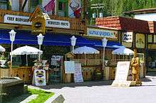
Kimberley incorporated as a city on March 29, 1944.[1] It amalgamated with the former Village of Marysville on November 1, 1968.[2] Following the routing of Highway 95 away from the city, in 1972 Kimberley transformed into the Bavarian City of the Rockies to entice motorists passing through the region to visit. Kimberley's Mine was the Sullivan Mine, and it was the largest lead-zinc mine in the world. The mine ceased operation in 2001.
Demographics
| Canada 2016 Census | Population | % of Total Population | |
|---|---|---|---|
| Visible minority group Source:[5] |
Chinese | 55 | 0.8% |
| South Asian | 20 | 0.3% | |
| Black | 10 | 0.1% | |
| Filipino | 60 | 0.8% | |
| Latin American | 10 | 0.1% | |
| Arab | 0 | 0% | |
| Southeast Asian | 10 | 0.1% | |
| West Asian | 0 | 0% | |
| Korean | 0 | 0% | |
| Japanese | 40 | 0.6% | |
| Other visible minority | 0 | 0% | |
| Mixed visible minority | 0 | 0% | |
| Total visible minority population | 195 | 2.7% | |
| Aboriginal group Source:[6] | First Nations | 170 | 2.3% |
| Métis | 190 | 2.6% | |
| Inuit | 0 | 0% | |
| Total Aboriginal population | 375 | 5.2% | |
| European Canadian | 6,670 | 92.1% | |
| Total population | 7,425 | 100% | |
Tourism and transportation

The city has the "largest freestanding cuckoo clock in Canada".
Kimberley is also home to a professional summer theatre which typically produces a mainstage musical at the local theatre and a free outdoor vaudeville show in the Platzl. Past productions include:You're a Good Man, Charlie Brown, Where's Charley?, By Jeeves, Lend Me A Tenor, Secrets Every Smart Traveler Should Know and several original scripts featuring local material. Kimberley Summer Theatre's mandate is to produce affordable but professional theatre for all ages. Productions are housed at the 125-seat "Centre 64". KST alumni include Elicia MacKenzie, winner of the CBC Television contest How Do You Solve a Problem Like Maria?.
Kimberley is served by the Canadian Rockies International Airport that has been expanded, and is expected by many to have a positive impact on commerce and tourism in the Kimberley area. The airport expansion will accommodate large charter and scheduled flights, opening up the area to more vacationers from across the country and abroad.
Schools
Schools in Kimberley are part of School District 6 Rocky Mountain which also serves Invermere and Golden. Five of the district schools are in Kimberley.
- Blarchmont Elementary School (closed as of September, 2006) and now home of the College of the Rockies Kimberley Campus
- Selkirk Secondary School
- McKim Elementary School (changed from a Middle School to a 4 to 7 school as of September, 2006)
- Marysville Elementary School
- Lindsay Park Elementary School
- Continuing Education School
- Kimberley Alternate School
Other schools accredited by the government:
- Kimberley Independent School (pre-K to grade 9)
Climate
Kimberley has a continental climate with semi-arid influences and heavy moderation from the nearby mountains which tend to block arctic air masses, and produce a rain shadow. Its fairly high elevation counters this effect slightly, as temperatures are somewhat cooler and the town slightly more rainy than it would otherwise be.
| Climate data for Kimberley | |||||||||||||
|---|---|---|---|---|---|---|---|---|---|---|---|---|---|
| Month | Jan | Feb | Mar | Apr | May | Jun | Jul | Aug | Sep | Oct | Nov | Dec | Year |
| Record high °C (°F) | 12.5 (54.5) |
14.0 (57.2) |
22.0 (71.6) |
26.0 (78.8) |
31.5 (88.7) |
34.0 (93.2) |
37.0 (98.6) |
36.0 (96.8) |
34.0 (93.2) |
26.5 (79.7) |
17.0 (62.6) |
8.5 (47.3) |
37.0 (98.6) |
| Average high °C (°F) | −1.7 (28.9) |
2.1 (35.8) |
7.6 (45.7) |
13.5 (56.3) |
18.2 (64.8) |
21.7 (71.1) |
26.5 (79.7) |
26.3 (79.3) |
21.0 (69.8) |
12.3 (54.1) |
3.1 (37.6) |
−2.5 (27.5) |
12.3 (54.1) |
| Daily mean °C (°F) | −6.8 (19.8) |
−4.1 (24.6) |
1.2 (34.2) |
6.5 (43.7) |
11.0 (51.8) |
14.5 (58.1) |
18.1 (64.6) |
17.6 (63.7) |
12.6 (54.7) |
5.6 (42.1) |
−1.4 (29.5) |
−6.8 (19.8) |
5.7 (42.3) |
| Average low °C (°F) | −11.9 (10.6) |
−10.3 (13.5) |
−5.3 (22.5) |
−0.6 (30.9) |
3.8 (38.8) |
7.2 (45) |
9.7 (49.5) |
8.9 (48) |
4.2 (39.6) |
−1.1 (30) |
−6.0 (21.2) |
−11.2 (11.8) |
−1.0 (30.2) |
| Record low °C (°F) | −36.5 (−33.7) |
−35.5 (−31.9) |
−26.0 (−14.8) |
−11.0 (12.2) |
−4.5 (23.9) |
−1.5 (29.3) |
0.5 (32.9) |
−2.0 (28.4) |
−2.5 (27.5) |
−7.0 (19.4) |
−19.0 (−2.2) |
−31.0 (−23.8) |
−35.0 (−31) |
| Average precipitation mm (inches) | 39.2 (1.543) |
28.9 (1.138) |
26.6 (1.047) |
28.2 (1.11) |
42.7 (1.681) |
55.8 (2.197) |
36.2 (1.425) |
27.0 (1.063) |
30.9 (1.217) |
25.8 (1.016) |
45.6 (1.795) |
44.7 (1.76) |
431.6 (16.992) |
| Average rainfall mm (inches) | 5.1 (0.201) |
5.0 (0.197) |
13.6 (0.535) |
24.0 (0.945) |
41.5 (1.634) |
55.8 (2.197) |
36.2 (1.425) |
27.0 (1.063) |
30.5 (1.201) |
22.0 (0.866) |
18.6 (0.732) |
4.1 (0.161) |
283.4 (11.157) |
| Average snowfall cm (inches) | 39.2 (15.43) |
23.9 (9.41) |
13.2 (5.2) |
4.2 (1.65) |
1.2 (0.47) |
0.0 (0) |
0.0 (0) |
0.0 (0) |
0.4 (0.16) |
2.8 (1.1) |
27.0 (10.63) |
40.6 (15.98) |
148.4 (58.43) |
| Source: Environment Canada[7] | |||||||||||||
Sports
The Kimberley Dynamiters Junior B Ice Hockey team play in the Kootenay International Junior Hockey League (KIJHL). The Dynamiters have produced many pro hockey players including Jason Wiemer, who last played with the New Jersey Devils of the National Hockey League (NHL).
Kimberley Alpine Resort regularly hosts ski races on the IPC Disabled Alpine World Cup. It's known as the sunniest resort in BC, and offers a wide range of runs, for all levels. Kimberley Alpine Resort is also home to the Winter Sports School which hosts lessons for all ages, and abilities, such as Black Forest Tours.
There are five major golf courses to play, Trickle Creek Golf Resort, which, along with Trickle Creek Lodge and Kimberley Alpine Resort, is owned by Resorts of the Canadian Rockies Inc., Bootleg Gap Golf Course, Kimberley Golf Club, and just 15 – 20 minutes away are the St Eugene Golf Resort and Shadow Mountain Golf Course, both of which have received rave reviews for their quality and incredible scenery. Additionally, new investment in the area is producing another golf course known as Wild Stone. The areas around Kimberley also have premiere golf courses, making Kimberley and the surrounding area a golf tourism destination.
There is an annual ultra marathon at Kimberley Alpine Resort, the Black Spur Ultra. Runners choose between 54 km and 108 km distances.[8]
| Club | League | Sport | Venue | Established | Championships |
|---|---|---|---|---|---|
| Kimberley Dynamiters | KIJHL | Ice Hockey | Kimberley Civic Centre | 1972 | 3 |
References
- 1 2 "British Columbia Regional Districts, Municipalities, Corporate Name, Date of Incorporation and Postal Address" (XLS). British Columbia Ministry of Communities, Sport and Cultural Development. Archived from the original on July 13, 2014. Retrieved February 21, 2014.
- 1 2 "Name Details: Marysville (Community)". GeoBC. Retrieved February 21, 2014.
- ↑ "Census Profile, 2016 Census - Kimberley, City Census subdivision, British Columbia and British Columbia Province". Statistics Canada.
- ↑ http://globalnews.ca/news/2145616/kimberleys-solar-plant-largest-in-western-canada-begins-operations/
- ↑ "Community Profiles from the 2011 Census, Statistics Canada – Census Subdivision". 2.statcan.gc.ca. 6 December 2010. Archived from the original on 10 April 2014. Retrieved 13 April 2013.
- ↑ "Aboriginal Peoples – Data table". 2.statcan.ca. 6 October 2010. Retrieved 13 April 2013.
- ↑ "Kimberley". Canadian Climate Normals 1981–2010 (in English and French). Environment Canada. Retrieved September 24, 2015.
- ↑ The Black Spur Ultra - Kimberley Daily Bulletin
External links
| Wikimedia Commons has media related to Kimberley, British Columbia. |
| Subdivisions |  | |
|---|---|---|
| Communities | ||
| Metro areas and agglomerations | ||
| Cities |
| |
| ||