Invermere Airport
| Invermere Airport | |||||||||||
|---|---|---|---|---|---|---|---|---|---|---|---|
 | |||||||||||
| Summary | |||||||||||
| Airport type | Private | ||||||||||
| Operator | Babin Air | ||||||||||
| Location | Invermere, British Columbia | ||||||||||
| Time zone | MST (UTC−07:00) | ||||||||||
| • Summer (DST) | MDT (UTC−06:00) | ||||||||||
| Elevation AMSL | 2,820 ft / 860 m | ||||||||||
| Coordinates | 50°31′N 116°00′W / 50.517°N 116.000°WCoordinates: 50°31′N 116°00′W / 50.517°N 116.000°W | ||||||||||
| Map | |||||||||||
 CAA8 Location in British Columbia | |||||||||||
| Runways | |||||||||||
| |||||||||||
|
Source: Canada Flight Supplement[1] | |||||||||||
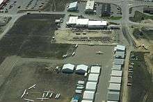
Invermere Airport, (TC LID: CAA8), is located 1.4 nautical miles (2.6 km; 1.6 mi) northeast of Invermere, British Columbia, Canada on the Shuswap Indian Band Reserve.
As described in the Canadian Flight Supplement it is a Prior Permission Required airport. Landing Fees are only applicable to Commercial Aircraft. It is mostly for small propeller driven aircraft being only 3000 ft long, and larger aircraft must use Fairmont Hot Springs Airport, around 20 km (12 mi) away.
In the Summer months there can be heavy Glider activity from Invermere Soaring Centre. Babin Air Ltd is the local air operator offering scenic and charter flights.
Activities
Invermere Airport
References
- ↑ Canada Flight Supplement. Effective 0901Z 19 July 2018 to 0901Z 13 September 2018.
| By name | |
|---|---|
| By location indicator | |
| By province/territory | |
| By area | |
| National Airports System | |
| Related | |
| |
This article is issued from
Wikipedia.
The text is licensed under Creative Commons - Attribution - Sharealike.
Additional terms may apply for the media files.