Fort St. James
| Fort St. James | |
|---|---|
| District municipality | |
| District of Fort St. James[1] | |
 | |
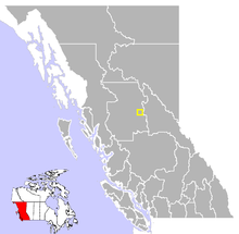 Location of Fort St. James in British Columbia | |
| Coordinates: 54°26′35″N 124°15′15″W / 54.44306°N 124.25417°W | |
| Country |
|
| Province |
|
| Region | Omineca Country |
| Regional district | Regional District of Bulkley Nechako |
| Founded | 1806 |
| Incorporated | 1952 |
| Government | |
| • Governing body | Municipal Council |
| • Mayor | Rob MacDougall |
| Area | |
| • Total | 23.47 km2 (9.06 sq mi) |
| Elevation | 700 m (2,300 ft) |
| Population (2011) | |
| • Total | 1,691 |
| • Density | 72.0/km2 (186/sq mi) |
| Time zone | UTC−8 (PST) |
| • Summer (DST) | UTC−7 (PDT) |
| Postal code span | V0J 1P0 |
| Area code(s) | +250, +778 |
| Highways | 27 |
| Waterways | Stuart Lake, Stuart River, Necoslie River, Nahounli Creek |
| Website | District of Fort St. James |
| Official name | Fort St. James National Historic Site of Canada |
| Designated | 1948 |
Fort St. James is a district municipality and former fur trading post in north-central British Columbia, Canada. It is located on the south-eastern shore of Stuart Lake in the Omineca Country, at the northern terminus of Highway 27, which connects to Highway 16 at Vanderhoof.
The community celebrated its bicentennial in 2006 and is incorporated as a district municipality.
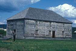
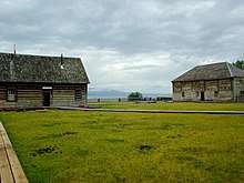
Fort St. James National Historic Site
Founded by the North West Company explorer and fur trader Simon Fraser in 1806, it came under the management of the Hudson's Bay Company in 1821 with the forced merger of the two battling fur companies. Also known historically as Stuart Lake Post, it is one of British Columbia's oldest permanent European settlements and was the administrative centre for the Hudson's Bay Company's New Caledonia fur district.[2] The fort, rebuilt four times, continued as an important trading post well into the twentieth century. Now the fort is a National Historic Site of Canada[3][4] with some buildings dating to the 1880s.
History
As part of his commission from the North West Company, Fraser and his assistants John Stuart and James McDougall explored potential river routes to the Pacific Ocean from 1805 through 1808. Explorations in the Winter of 1805-06 by McDougall resulted in the discovery of Carrier's Lake, now known as Stuart Lake. In the heart of territory inhabited by the Carrier or Dakelh First Nation, this proved to be a lucrative locale for fur trading and so a post - Fort St. James - was built on its shore in 1806. In 1821, the fort came under the control of the Hudson's Bay Company, when the North West Company merged with it. It subsequently became the administrative headquarters of the Company's vast New Caledonia District.
The fur trade was slow to take route in the area, since the economy of the Dakelh people had been based on the fishery, rather than on trapping. In addition, there were customary and ceremonial restrictions which placed obstacles in the way of an efficient fur economy. Nonetheless, eventually the post became profitable, and continued to function until its closure in 1952.
The community is located on the south-eastern shore of Stuart Lake, at the head of the Stuart River. Both the lake and the river are named for Fraser's assistant John Stuart, who would later become head of the New Caledonia District of the North West Company.
Climate
Fort St. James is located in the sub-boreal spruce zone of British Columbia, a sub-division of the hemiboreal climatic zone. It is characterised by severe, snowy winters and short, warm summers. The region is rich in wildlife. Under the Köppen climate classification Fort St. James is classified as a humid continental climate (Dfb).
| Climate data for Fort St. James, 1981–2010 normals, extremes 1895–present | |||||||||||||
|---|---|---|---|---|---|---|---|---|---|---|---|---|---|
| Month | Jan | Feb | Mar | Apr | May | Jun | Jul | Aug | Sep | Oct | Nov | Dec | Year |
| Record high °C (°F) | 12.0 (53.6) |
13.0 (55.4) |
17.1 (62.8) |
24.4 (75.9) |
35.0 (95) |
33.9 (93) |
36.7 (98.1) |
35.6 (96.1) |
29.5 (85.1) |
26.5 (79.7) |
16.1 (61) |
11.0 (51.8) |
36.7 (98.1) |
| Average high °C (°F) | −5.3 (22.5) |
−1.7 (28.9) |
4.0 (39.2) |
9.9 (49.8) |
15.6 (60.1) |
19.6 (67.3) |
21.8 (71.2) |
21.7 (71.1) |
16.4 (61.5) |
9.0 (48.2) |
0.6 (33.1) |
−3.8 (25.2) |
9.0 (48.2) |
| Daily mean °C (°F) | −9.5 (14.9) |
−6.8 (19.8) |
−1.8 (28.8) |
3.9 (39) |
9.2 (48.6) |
13.4 (56.1) |
15.4 (59.7) |
14.8 (58.6) |
10.2 (50.4) |
4.3 (39.7) |
−3.0 (26.6) |
−7.8 (18) |
3.5 (38.3) |
| Average low °C (°F) | −13.7 (7.3) |
−11.8 (10.8) |
−7.7 (18.1) |
−2.2 (28) |
2.8 (37) |
7.2 (45) |
8.9 (48) |
7.9 (46.2) |
3.9 (39) |
−0.5 (31.1) |
−6.5 (20.3) |
−11.7 (10.9) |
−2.0 (28.4) |
| Record low °C (°F) | −49.4 (−56.9) |
−49.4 (−56.9) |
−39.4 (−38.9) |
−29.4 (−20.9) |
−11.7 (10.9) |
−6.1 (21) |
−5.6 (21.9) |
−7.8 (18) |
−13.3 (8.1) |
−23.0 (−9.4) |
−37.8 (−36) |
−47.2 (−53) |
−49.4 (−56.9) |
| Average precipitation mm (inches) | 48.1 (1.894) |
30.0 (1.181) |
25.7 (1.012) |
23.7 (0.933) |
38.9 (1.531) |
50.6 (1.992) |
50.6 (1.992) |
45.0 (1.772) |
39.3 (1.547) |
48.1 (1.894) |
44.5 (1.752) |
42.6 (1.677) |
487.2 (19.181) |
| Average rainfall mm (inches) | 4.9 (0.193) |
3.6 (0.142) |
5.9 (0.232) |
18.0 (0.709) |
38.2 (1.504) |
50.6 (1.992) |
50.6 (1.992) |
45.0 (1.772) |
39.1 (1.539) |
38.7 (1.524) |
15.7 (0.618) |
4.2 (0.165) |
314.5 (12.382) |
| Average snowfall cm (inches) | 43.3 (17.05) |
26.4 (10.39) |
19.8 (7.8) |
5.7 (2.24) |
0.7 (0.28) |
0 (0) |
0 (0) |
0 (0) |
0.2 (0.08) |
9.5 (3.74) |
28.8 (11.34) |
38.4 (15.12) |
172.7 (67.99) |
| Average precipitation days (≥ 0.2 mm) | 12.7 | 8.9 | 8.6 | 8.3 | 12.4 | 12.7 | 13.7 | 11.3 | 12.1 | 14.0 | 13.1 | 11.3 | 139.1 |
| Average rainy days (≥ 0.2 mm) | 2.0 | 1.8 | 3.2 | 6.8 | 12.2 | 12.7 | 13.7 | 11.3 | 12.1 | 12.4 | 5.3 | 1.8 | 95.2 |
| Average snowy days (≥ 0.2 cm) | 11.4 | 7.4 | 6.0 | 2.2 | 0.4 | 0 | 0 | 0 | 0.08 | 2.4 | 9.0 | 10.0 | 48.8 |
| Average relative humidity (%) | 81.6 | 72.6 | 57.0 | 45.0 | 44.1 | 48.0 | 47.3 | 47.7 | 52.7 | 62.9 | 79.8 | 84.2 | 60.2 |
| Mean monthly sunshine hours | 51.3 | 85.5 | 151.3 | 207.6 | 245.7 | 260.2 | 275.3 | 256.8 | 177.7 | 116.0 | 60.2 | 41.0 | 1,928.6 |
| Percent possible sunshine | 20.8 | 31.3 | 41.3 | 49.3 | 49.5 | 50.6 | 53.4 | 55.6 | 46.4 | 35.4 | 23.5 | 17.9 | 39.6 |
| Source: Environment Canada,[5][6][7] (Sunshine and humidity data from Fort St. James Airport) | |||||||||||||
Demographics
The population of the greater Fort St. James area is around 5000, of whom about one quarter identify as being of First Nations origin[8] The town is surrounded by numerous, small First Nations communities and Indian reserves, including Pinchie, Tachie, and Nak'azdli.
Between 2006 and 2011, the District of Fort St. James recorded the second-highest population growth of all British Columbia municipalities. The District's population grew from 1350 to 1691, for a percentage increase of 25.3%. Only Langford, at 30.1%, recorded a higher growth rate.
Economy
The local economy is well diversified, although resource-oriented. The forest industries constitute the leading sector followed by mining, agriculture and tourism. Recent developments also include a small high technology sector.
Notable people
- Jim Playfair, Associate Coach of the Phoenix Coyotes, NHL
- Larry Playfair, Former NHL player with the Buffalo Sabres and the Los Angeles Kings
- Brian Spencer "Spinner", former player in the National Hockey League and the subject of the film, 'Gross Misconduct'.
- Chief Kwah (aka Chief Kw’eh), (ca. 1755-1840), leading Dakelh chief of the Stuart Lake area.
- Cody Legebokoff, convicted serial killer
- Johan Pitka, Estonian military commander
See also
References
- ↑ "British Columbia Regional Districts, Municipalities, Corporate Name, Date of Incorporation and Postal Address" (XLS). British Columbia Ministry of Communities, Sport and Cultural Development. Archived from the original on 13 July 2014. Retrieved November 2, 2014.
- ↑ "Fort St. James (District Municipality)". BC Geographical Names.
- ↑ Fort St. James. Canadian Register of Historic Places. Retrieved 8 January 2012.
- ↑ "Fort Saint James National Historic Site". BC Geographical Names.
- ↑ "Fort St James". Environment Canada. Retrieved 5 March 2017.
- ↑ "Daily Data Report for March 2016". Environment Canada. Retrieved 5 March 2017.
- ↑ "Fort St James A". Environment Canada. Retrieved 5 March 2017.
- ↑ Community Profile, Statistics Canada, 2001 Canadian census
External links
- Municipal website, includes extensive community information
- Fort St. James Web
- Fort St. James National Historic Site, Parks Canada website offers a good historical background
- Regional District of Bulkley Nechako website
- Caledonia Courier newspaper
- FSJ Voice – news, forums and links useful to visitors and residents of Fort St. James
| Subdivisions |  | |
|---|---|---|
| Communities | ||
| Metro areas and agglomerations | ||
| District municipalities |
| |
| ||
Historic HBC operations in the Pacific Northwest | |||||
| Columbia Department | |||||
| New Caledonia District |
| ||||
Coordinates: 54°26′35″N 124°15′15″W / 54.44306°N 124.25417°W