History of Gilgit-Baltistan
Part of a series on the |
|---|
| History of Pakistan |
 |
| Timeline |
|
Ancient
|
|
Classical
|
|
Medieval
|
|
Early modern
|
|
Modern
|
|
History of provinces |
|
Gilgit Baltistan is an administrative territory of Pakistan, that borders the province of Khyber Pakhtunkhwa to the west, Azad Kashmir to the southwest, Wakhan Corridor of Afghanistan to the northwest, the Xinjiang Uyghur Autonomous Region of China to the north, and the Indian state of Jammu and Kashmir to the south and southeast.
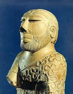
Rock art and petroglyphs
There are more than 50,000 pieces of rock art (petroglyphs) and inscriptions all along the Karakoram Highway in Gilgit Baltistan, concentrated at ten major sites between Hunza and Shatial. The carvings were left by various invaders, traders, and pilgrims who passed along the trade route, as well as by locals. The earliest date back to between 5000 and 1000 BCE, showing single animals, triangular men and hunting scenes in which the animals are larger than the hunters. These carvings were pecked into the rock with stone tools and are covered with a thick patina that proves their age. The ethnologist Karl Jettmar has pieced together the history of the area from various inscriptions and recorded his findings in Rock Carvings and Inscriptions in the Northern Areas of Pakistan[1] and the later released Between Gandhara and the Silk Roads - Rock Carvings Along the Karakoram Highway.[2]
British Raj
It took a long time for the Maharajahs Ghulab Singh and Ranbir Singh to extend their writ over Gilgit, Hunza and Nagar, and not until 1870 did they assert their authority over Gilgit town. The grip of the Jammu and Kashmir government over this area was tenuous. The Indian government undertook administrative reforms in 1885 and created Gilgit Agency in 1889 as a way for the British to secure the region as a buffer from the Russians. As a result of this Great Game, with British fear of Russian activities in Chinese Sinkiang increasing, in 1935 the Gilgit Agency was expanded by the Maharajah Hari Singh leasing the Gilgit Wazarat to the government of India for a period of sixty years and for an amount of 75,000Rs. This gave the British political agent complete control of defence, communications and foreign relations while the Kashmiri state retained civil administration and the British retained control of defence and foreign affairs.[3]
After World War II British influence started declining. British despite decline in its rule, handled the situation cleverly and gave two options to the states in British Raj under their rule to join any of the two emerging states, India and Pakistan. In 1947, Mountbatten decided to terminate the lease of Gilgit by Kashmir to the British. Scholar Yaqoob Khan Bangash opines that the motive for this is unclear.[4]
The people of Gilgit thought themselves to be ethnically different from the Kashmiris and resented being under Kashmir state rule. Gilgit was also one of the most backward areas of the Kashmir state. Major William Brown, the Maharaja's commander of the Gilgit Scouts, believed that the British handover of Gilgit to Kashmir was a huge mistake.[5]
Brown recounts that when he met the scouts ''they indirectly made it clear how they despised and hated Kashmir and everything connected with it, how happy and content they had been under the British rule, and how they considered they had been betrayed by the British in the unconditional handing over of their country to Kashmir''.[5]
Taking advantage of the situation the populace of Gilgit-Baltistan started revolting, the people of Ghizer were first to raise the flag of revolution, and gradually the masses of entire region stood up against the rule of Maharaja, again British played an important role in war of independence of Gilgit-Baltistan.[6]
End of the princely state
Stories of communal violence by Hindus and Sikhs against Muslims in Punjab reached Gilgit and inflamed passions against the small Hindu and Sikh minorities in Gilgit. On 26 October 1947, Maharaja Hari Singh of Jammu and Kashmir, faced with a tribal invasion from Pakistan, signed the Instrument of Accession, joining India.
Gilgit's population did not favour the State's accession to India. According to Bangash, Muzzaffar, the raja orderly in Chilas, represented the views of the region's people when he said:
The whole of Gilgit Agency is pro-Pakistan ... we could never swear allegiance to Hindustan. Apart from religion, the Gilgit Agency is really a part of the NWFP and is therefore a part of Pakistan. If Kashmir remains independent, well and good ... .But if the Maharaja through pig headedness and bad advice, political pressure or attractive remunerations accedes to Hindustan, then there will be trouble here![7]
Sensing their discontent, Brown mutinied on 1 November 1947, overthrowing the Governor Ghansara Singh. The bloodless coup d'etat was planned by Brown to the last detail under the code name `Datta Khel'. A provisional government (Aburi Hakoomat) was established by the Gilgit locals with Raja Shah Rais Khan as the president and Mirza Hassan Khan as the commander-in-chief. However, Major Brown had already telegraphed Khan Abdul Qayyum Khan asking Pakistan to take over. The Pakistani political agent, Khan Mohammad Alam Khan, arrived on 16 November and took over the administration of Gilgit.[8] According to Brown,[9]
Alam replied [to the locals], "you are a crowd of fools led astray by a madman. I shall not tolerate this nonsense for one instance... And when the Indian Army starts invading you there will be no use screaming to Pakistan for help, because you won't get it."... The provisional government faded away after this encounter with Alam Khan, clearly reflecting the flimsy and opportunistic nature of its basis and support.[10]
The provisional government lasted 16 days. The provisional government lacked sway over the population. The Gilgit rebellion did not have civilian involvement and was solely the work of military leaders, not all of whom had been in favor of joining Pakistan, at least in the short term. Dani mentions that although there was lack of public participation in the rebellion, pro-Pakistan sentiments were intense in the civilian population and their anti-Kashmiri sentiments were also clear.[11] Scholar Yaqoob Khan Bangash states that the people of Gilgit as well as those of Chilas, Koh Ghizr, Ishkoman, Yasin, Punial, Hunza and Nagar joined Pakistan by choice.[12][13]
After taking control of Gilgit, the Gilgit Scouts along with Azad irregulars moved towards Baltistan and Ladakh and captured Skardu by May 1948. They successfully blocked the Indian reinforcements and subsequently captured Dras and Kargill as well, cutting off the Indian communications to Leh in Ladakh. The Indian forces mounted an offensive in Autumn 1948 and recaptured all of Kargil district. Baltistan region, however, came under Gilgit control.[14][15]
On 1 January 1948, India took the issue of Jammu and Kashmir to the United Nations Security Council. In April 1948, the Council passed a resolution calling for Pakistan to withdraw from all of Jammu and Kashmir and then India was to reduce its forces to the minimum level, following which a plebiscite would be held to ascertain the people's wishes.[16] However, no withdrawal was ever carried out, India insisting that Pakistan had to withdraw first and Pakistan contending that there was no guarantee that India would withdraw afterwards.[17] Gilgit-Baltistan and a western portion of the state called Azad Jammu and Kashmir) have remained under the control of Pakistan since then.[18]
Part of Pakistan
1947 to 1970 Government of Pakistan established Gilgit Agency and Baltistan Agency. In 1970 Northern areas council established by Zulfiqar Ali Bhutto and Gilgit Baltistan was directly administrated by federal government and it was called FANA(Federal administrated northern areas). In 1963, Pakistan ceded a part of Hunza-Gilgit called Raskam and the Shaksgam Valley of Baltistan region to the China pending settlement of the dispute over Kashmir. This ceded area is also known as the Trans-Karakoram Tract. The Pakistani parts of Kashmir to the north and west of the cease-fire line established at the end of the Indo-Pakistani War of 1947, or the Line of Control as it later came to be called, were divided into the Northern Areas (72,971 km²) in the north and the Pakistani state of Azad Kashmir (13,297 km²) in the south. The name "Northern Areas" was first used by the United Nations to refer to the northern areas of Kashmir.
Gilgit Baltistan, which was most recently known as the Northern Areas, presently consists of ten districts,[19] has a population approaching two million, has an area of approximately 28,000 square miles (73,000 km2), and shares borders with China, Afghanistan, and India. The local Northern Light Infantry is the army unit that participated in the 1999 Kargil conflict. More than 500 soldiers were believed to have been killed and buried in the Northern Areas in that action.[20] Lalak Jan, a soldier from Yasin Valley, was awarded Pakistan's most prestigious medal, the Nishan-e-Haider, for his courageous actions during the Kargil conflict.
Self-governing status and present-day Gilgit Baltistan
On 29 August 2009, the Gilgit Baltistan Empowerment and Self-Governance Order, 2009, was passed by the Pakistani cabinet and later signed by the President of Pakistan. The order granted self-rule to the people of the former Northern Areas, now renamed Gilgit Baltistan, by creating, among other things, an elected legislative assembly.
There has been an uplift in the self-identification of this territory's inhabitants through the name change but it has still left the region's constitutional status within Pakistan undefined. The 2009 reform has failed to answer the people's demands for citizenship rights. According to Antia Mato Bouzas, the move was the Pakistani government's compromise between its official stand on Kashmir and demands of a territory where the majority of people may have pro-Pakistan sentiments.[21]
There has been some criticism and opposition to this move in India and Gilgit Baltistan region of Pakistan.[22][23]
Gilgit Baltistan United Movement while rejecting the new package demanded that an independent and autonomous legislative assembly for Gilgit Baltistan should be formed with the installation of local authoritative government as per the UNCIP resolutions, where the people of Gilgit Baltistan will elect their president and the prime minister.[24]
In early September 2009, Pakistan signed an agreement with the People's Republic of China for a mega energy project in Gilgit–Baltistan which includes the construction of a 7,000-megawatt dam at Bunji in the Astore District.[25] This also resulted in protest from India, although Indian concerns were immediately rejected by Pakistan, which claimed that the Government of India has no locus standi in the matter, effectively ignoring the validity of the princely state's Instrument of Accession on October 26, 1947.
On 29 September 2009, the Prime Minister, while addressing a huge gathering in Gilgit–Baltistan, announced a multi-billion rupee development package aimed at the socio-economic uplifting of people in the area. Development projects will include the areas of education, health, agriculture, tourism and the basic needs of life.[26][27]
References
- ↑ "Rock Carvings and Inscriptions along the Karakorum Highway (Pakistan) - - a brief introduction". Archived from the original on 2011-08-10.
- ↑ "Between gandhara and the silk roads". Archived from the original on 2011-09-27.
- ↑ Yaqoob Khan Bangash (2010) Three Forgotten Accessions: Gilgit, Hunza and Nagar, The Journal of Imperial and Commonwealth History, 38:1, 121, DOI: 10.1080/03086530903538269
- ↑ Yaqoob Khan Bangash (2010) Three Forgotten Accessions: Gilgit, Hunza and Nagar, The Journal of Imperial and Commonwealth History, 38:1, 124, DOI: 10.1080/03086530903538269
- 1 2 Yaqoob Khan Bangash (2010) Three Forgotten Accessions: Gilgit, Hunza and Nagar, The Journal of Imperial and Commonwealth History, 38:1, 125-126, DOI: 10.1080/03086530903538269
- ↑ "History, movements and freedom".
- ↑ Yaqoob Khan Bangash (2010) Three Forgotten Accessions: Gilgit, Hunza and Nagar, The Journal of Imperial and Commonwealth History, 38:1, 127, DOI: 10.1080/03086530903538269
- ↑ Schofield 2003, pp. 63-64.
- ↑ Bangash, Yaqoob Khan, "Three Forgotten Accessions: Gilgit, Hunza and Nagar", The Journal of Imperial and Commonwealth History, 38 (1): 117–143, doi:10.1080/03086530903538269, (Subscription required (help))
- ↑ Bangash 2010, p. 133.
- ↑ Yaqoob Khan Bangash (2010) Three Forgotten Accessions: Gilgit, Hunza and Nagar, The Journal of Imperial and Commonwealth History, 38:1, 132, DOI: 10.1080/03086530903538269
- ↑ Yaqoob Khan Bangash (2010) Three Forgotten Accessions: Gilgit, Hunza and Nagar, The Journal of Imperial and Commonwealth History, 38:1, 137, DOI: 10.1080/03086530903538269
- ↑ Bangash, Yaqoob Khan (9 January 2016). "Gilgit-Baltistan—part of Pakistan by choice". The Express Tribune. Retrieved 5 January 2017.
Nearly 70 years ago, the people of the Gilgit Wazarat revolted and joined Pakistan of their own free will, as did those belonging to the territories of Chilas, Koh Ghizr, Ishkoman, Yasin and Punial; the princely states of Hunza and Nagar also acceded to Pakistan. Hence, the time has come to acknowledge and respect their choice of being full-fledged citizens of Pakistan.
- ↑ Schofield 2003, p. 66.
- ↑ Bajwa, Farooq (2013), From Kutch to Tashkent: The Indo-Pakistan War of 1965, Hurst Publishers, pp. 22–24, ISBN 978-1-84904-230-7
- ↑ Bose, Tapan K. (2004). Raṇabīra Samāddāra, ed. Peace Studies: An Introduction To the Concept, Scope, and Themes. Sage. p. 324. ISBN 978-0761996606.
- ↑ Varshney, Ashutosh (1992), "Three Compromised Nationalisms: Why Kashmir has been a Problem" (PDF), in Raju G. C. Thomas, Perspectives on Kashmir: the roots of conflict in South Asia, Westview Press, p. 212, ISBN 978-0-8133-8343-9
- ↑ Warikoo, Kulbhushan (2008). Himalayan Frontiers of India: Historical, Geo-Political and Strategic Perspectives (1st ed.). Routledge. p. 78. ISBN 978-0415468398.
- ↑ Dividing governance: Three new districts notified in G-B, The Express Tribune, 5 February 2017.
- ↑ Special Report on Kargil", The Herald (Pakistan)
- ↑ Antia Mato Bouzas (2012) Mixed Legacies in Contested Borderlands: Skardu and the Kashmir Dispute, Geopolitics, 17:4, 874, DOI: 10.1080/14650045.2012.660577
- ↑ "The Gilgit–Baltistan bungle". The News International. 2009-09-10. Archived from the original on 28 December 2017. Retrieved 2010-06-05.
- ↑ Gilgit-Baltistan package termed an eyewash, Dawn, 2009-08-30 Archived May 3, 2010, at the Wayback Machine.
- ↑ "Gilgit–Baltistan: GBUM Calls for Self-Rule Under UN Resolutions". UNPO. 2009-09-09. Retrieved 2010-06-05.
- ↑ "Pakistan | Gilgit–Baltistan autonomy". Dawn.Com. 2009-09-09. Archived from the original on September 12, 2009. Retrieved 2010-06-05.
- ↑ Manzar Shigri (2009-11-12). "Pakistan's disputed Northern Areas go to polls". Reuters. Retrieved 2010-06-05.
- ↑ "Pakistani president signs Gilgit–Baltistan autonomy order _English_Xinhua". News.xinhuanet.com. 2009-09-07. Retrieved 2010-06-05.
- Sources
- Schofield, Victoria (2003) [First published in 2000], Kashmir in Conflict, London and New York: I. B. Taurus & Co, ISBN 1860648983
- Antia Mato Bouzas (2012) Mixed Legacies in Contested Borderlands: Skardu and the Kashmir Dispute, Geopolitics, 17:4, 867-886, DOI: 10.1080/14650045.2012.660577
External links
| Passes | 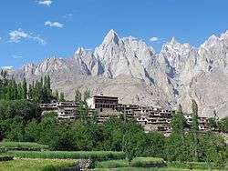 | |
|---|---|---|
| Valleys | ||
| Cities and towns | ||
| Rivers, glaciers and lakes | ||
| Architecture | ||
| See also | ||
| Provinces |
| ||||
|---|---|---|---|---|---|
| Territories |
| ||||