Bagrot Valley
| وادی بگروٹ | |
|---|---|
| Bagrote Valley | |
 | |
| Country |
|
| Autonomous state | Gilgit-Baltistan |
| District | Gilgit |
| Tehsil | Danyore |
| Population [1] | |
| • Total | 25,000 |
| Demonym(s) | Bagoreh |
| Time zone | UTC+5:30 (PST) |
| • Summer (DST) | +5 |
| Postal code | 15110 |
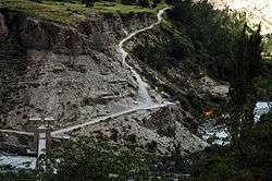
Bagrote Valley (Urdu: وادی بگروٹ) is a valley in the Karakoram Mountain range in the Gilgit–Baltistan region of northern Pakistan.[2] [3] River Bagrote flows through the valley from north towards southwest of the valley, supplies water to Jalalabad and Oshikhandass and merges with the Gilgit River.
Geography
The Bagrot valley extends between 2,500 and 4500 meters above sea level. The principle locality of the valley is Farfu (formerly called Furpui), also known for its spectacular landscape and high mountains such as Rakaposhi 7788 m, Diran 7266 m[4], Dubani 6138 m and the summit of Fafuraj , Miar Peak, Godeli and many other peaks that surpass six thousand meters above sea level. Doboi glaciers, Gargo, Yunay, Boi Pharai, Hurangi and Raka Poshi surround the valley from where the rivulets forming the Bagrot River are traced.[5] The River Bagrot passes by all the villages of the valley, including Jalalabad and Oshikhandass and merges with the Gilgit River.

Demography
Shina language is spoken and understood in all villages of Bagrote. The vernacular of Bagrote valley is typical and distinguishable as a dialect, with their lifestyle, cuisines, and culture Bagoreh form an ethnic group.
Tourism and Economy
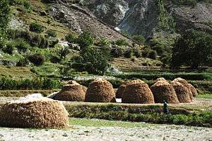
Tourists visit this valley mostly in summer. The valley is about half an hour's drive from Gilgit city. This valley is known for its fruits and vegetables, also for the glaciers and high peaks. Vegetables, fruits, and other seasonal crops and Ice from the Glaciers during summers are transported from the valley to the capital Gilgit, so far no ice factory in Gilgit is working in region. Ice is brought from the Glacier of Karakoram range. The villages of Hamaran, Sinaker, Datuchi, Bulchi, Chirah, Farfu and Hopay lie here and are interconnected by an unmettalled road. Villages on either side of the valley are linked via cable cars (allowing for easy transport of goods and livestock) and the river passes underneath which comes from glaciers of Karakoram Range.The means of economy is agriculture. However with the recent construction of the Karakorum Highway, the area has been exposed to western civilization, with small cinemas, retail outlets for mountain equipment and apparel, and small hotels opening to facilitate visitors. Locals grow Wheat, tomatoes, potatoes, apples, pears, apricots etc in the valley.[6][7]
Vallies nearby
References
- ↑ Bagrote Valley Pakistan
- ↑ Bagrote Valley Gilgit-Baltistan
- ↑ Explore Pakistan Tourism
- ↑ "Panoramio - Photo of Diran | Diran Peak Bagrote Gilgit". www.panoramio.com.
- ↑ "Bagrot valley of Gilgit loses forests, the only source of livelihood". thenaturenews.com.
- ↑ Bagrote Valley
- ↑ Bagrot valley of Gilgit loses forests, the only source of livelihood
External links