Chorbat Valley
| Chorbat Valley | |
|---|---|
| Valley | |
 Pakistan | |
| Coordinates: 34°57′22″N 76°34′49″E / 34.95611°N 76.58028°ECoordinates: 34°57′22″N 76°34′49″E / 34.95611°N 76.58028°E | |
| Country | Pakistan & India |
| Province | Gilgit Baltistan |
| Area | |
| • Total | 4,052 km2 (1,564 sq mi) |
| Population (2010) | |
| • Total | 20,000 |
| Time zone | UTC+5 (PST) |
Chorbat Valley (Urdu: وادی چھوربٹ, Balti: སྦལ་ཏིའི་) is a valley in Khaplu tehsil, Ghanche District, in Gilgit–Baltistan, Pakistan and in south east of Nubra valley Ladakh India. It stretches from the northeastern half of shyouk valley from Abandon village of Pakistani administrated ghanche district to Bogdang village of Indian administrated nubra valley. Churbat on many occasion is incorporated with Khaplu valley, although virtually it also took it own distinction, Even sometimes it is consider differently (due to its geography and peculiar accent of language). All people of Churbat valley are Muslims (Nurbakshis) while it is the last northeastern valley from where the geography of Baltistan ends, while Ladakh begins.
Geography and climate
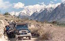
The valley is surrounded by high rising peaks of the Karakoram mountain range and the bank the Shyok River. The climate is hard with little rain and extremely cold winters due to proximity to Siachen Glacier and other peaks and glaciers.
Resources
The natural resources of the valley include agriculture, horticultural resources, the shyok River, mountains and peaks.
The agriculture in the Valley is only summer based due to extreme cold in the winter where temperature goes to minus 10. The crops include some beans, maize and other food crops however communities have experimented less with the agriculture due to the natural limiting factors i.e. extreme cold.
Chorbat valley consists of more than 13 villages in Pakistan and 6 villages in India, in Pakistan villages of Chhorbat is Dawou, Marcha, Kuwas, Hassanabad, Partuk, Piun, Siksa, Kalaan, Sukhmos, Chhowar, Thongmus, Siari, & Franu, and in India, the villages are, Doethang, Tyaqsi, Turtuk, Chalunka, Beyoqdan.[1][2]
As the war of 1971 rapidly escalated, the Indian army crossed the Line of Control (LoC) that divides the Himalayan region into Pakistani and Indian territories, and occupied Chalunka, Tyakshi, Thang and Turtuk of Chorbat village in Ghanche district on the Pakistani side.[3] The morning came and people who used to live in Pakistan were suddenly a part of an area controlled by another nation.[4]
Surroundings
The mountains and surrounding have generally no forests however there are some shrubs and herbs available which are generally used by the local communities as medicinal herbs, there is also a human-made forest in the saling which the largest forest in the whole district.
The Shyok River passing nearby the valley is one of the important resources of the area, irrigating the whole land. However the same river sometime creates havoc during summer through its unpredictable floods.
Indian intrusion
In 1972, shortly after the signing of the Shimla Agreement, the Indian troops crossed the Line of Control (LoC) in the Chorbat La sector and seized about 4 square miles of Pakistani territory.[5] In 1988, India again crossed the LoC and seized four Pakistani posts in the Qamar sector.[5] In 1992, the Indian troops captured the "Anzbari feature" near Kanzalwan, but following the Director General of Military Operations (DGMO) level talks with Pakistan it was returned.[5] However, after the 1999 Kargil War, India once again captured it.[5]
References
- ↑ "Turtuk, a Promised Land Between Two Hostile Neighbours".
- ↑ "An encounter with the 'king' of Turtuk, a border village near Gilgit-Baltistan".
- ↑ "A portrait of a village on the border".
- ↑ http://tribune.com.pk/story/1022109/man-reunites-with-father-after-1971-war/
- 1 2 3 4 Lavoy, Peter René (2009). Asymmetric Warfare in South Asia: The Causes and Consequences of the Kargil Conflict (illustrated ed.). Cambridge University Press. p. 58. ISBN 9780521767217.