Panamá Oeste Province
| Panamá Oeste Province Provincia de Panamá Oeste | ||
|---|---|---|
| Province | ||
| ||
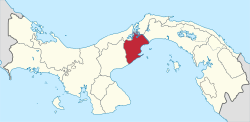 Location of Panama Oeste Province in Panama | ||
| Coordinates: 8°52′49″N 79°47′0″W / 8.88028°N 79.78333°WCoordinates: 8°52′49″N 79°47′0″W / 8.88028°N 79.78333°W | ||
| Country | Panama | |
| Created | 1 January 2014 | |
| Capital city | La Chorrera | |
| Government | ||
| • Governor | Temístocles Javier Herrera[1] | |
| Area | ||
| • Total | 2,786 km2 (1,076 sq mi) | |
| Population (2010 census) | ||
| • Total | 464,038 | |
| • Density | 170/km2 (430/sq mi) | |
| Time zone | UTC-5 (Eastern Time) | |
| ISO 3166 code | PA-10 | |
Panamá Oeste (Spanish pronunciation: [panaˈma oˈeste]; "West Panama" in English) is the newest province in Panama.
It was created from the five districts of Panamá Province west of the Panama Canal on 1 January 2014.[2] The capital is La Chorrera.
Administrative divisions
Panamá Oeste Province is divided into 5 districts and 59 corregimientos.[2]
References
- ↑ "Ministro Henríquez juramenta al nuevo Gobernador de la Décima Provincia". Government of Panama. 15 July 2014. Archived from Ministro Henríquez juramenta al nuevo Gobernador de la Décima Provincia the original Check
|url=value (help) on 9 July 2015. Retrieved 13 June 2015. - 1 2 Gaceta Oficial de Panamá (30 December 2013). "Ley Nº119 del 30 de diciembre de 2013: Que crea la provincia de Panamá Oeste, segregada de la provincia de Panamá" (PDF).
Capital: La Chorrera | ||
| Arraiján District | | |
| Capira District | ||
| Chame District | ||
| La Chorrera District | ||
| San Carlos District | ||
| Provinces | ||
|---|---|---|
Corregimiento-level Comarcas indígenas | ||
This article is issued from
Wikipedia.
The text is licensed under Creative Commons - Attribution - Sharealike.
Additional terms may apply for the media files.