Arlington Cemetery station
Arlington Cemetery | |||||||||||
|---|---|---|---|---|---|---|---|---|---|---|---|
|
| |||||||||||
 | |||||||||||
| Location |
1000 North Memorial Drive Arlington, VA 22211 | ||||||||||
| Coordinates | 38°53′4.5″N 77°3′47.1″W / 38.884583°N 77.063083°WCoordinates: 38°53′4.5″N 77°3′47.1″W / 38.884583°N 77.063083°W | ||||||||||
| Owned by | WMATA | ||||||||||
| Line(s) |
| ||||||||||
| Platforms | 2 side platforms | ||||||||||
| Tracks | 2 | ||||||||||
| Connections |
| ||||||||||
| Construction | |||||||||||
| Structure type | Open-cut | ||||||||||
| Disabled access | Yes | ||||||||||
| Other information | |||||||||||
| Station code | C06 | ||||||||||
| History | |||||||||||
| Opened | July 1, 1977 | ||||||||||
| Traffic | |||||||||||
| Passengers (2017) |
1,476 daily [1] | ||||||||||
| Services | |||||||||||
| |||||||||||
| Location | |||||||||||
 | |||||||||||
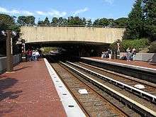
Arlington Cemetery is a side platformed Washington Metro station in Arlington, Virginia, United States. The station was opened on July 1, 1977, and is operated by the Washington Metropolitan Area Transit Authority (WMATA). The station provides service for only the Blue Line, and is located at the entrance to Arlington National Cemetery, underneath Memorial Drive. There is no public parking near the station except at the cemetery, which is reserved for cemetery visitors. It is the only station that closes earlier than the rest of the system, closing at 7 PM from October to March, and 10 PM from April to September.[2] The station is also unique in its design. It is just below ground level, and is only covered by a bridge carrying Memorial Drive. The station is one of three stations to be exclusively serviced by the Blue Line, as the rest of the Blue Line's stations except two are shared with the Yellow Line to the south and with the Silver Line and Orange Line to the north.
The station opened on July 1, 1977.[3] Its opening coincided with the completion of 11.8 miles (19.0 km)[4] of rail between National Airport and RFK Stadium and the opening of the Capitol South, Crystal City, Eastern Market, Farragut West, Federal Center SW, Federal Triangle, Foggy Bottom–GWU, L'Enfant Plaza, McPherson Square, National Airport, Pentagon, Pentagon City, Potomac Avenue, Rosslyn, Smithsonian, and Stadium–Armory stations.[5]
Station layout
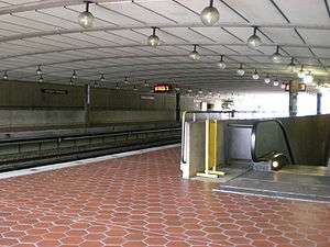
Escalators from Memorial Drive go down two levels to the mezzanine, where customers may purchase SmarTrip cards at vending machines and pass through the faregates. Escalators on the other side of the faregates then go up to the platforms. Elevators go directly to the platforms with one two-way faregate for each elevator at platform level.
| G | Street level | Exit/entrance |
| P Platform level |
Side platform, doors will open on the right | |
| Southbound | ← | |
| Northbound | → | |
| Side platform, doors will open on the right | ||
| M | Mezzanine | One-way faregates, ticket machines, station agent |
Notable places nearby
- Arlington House (also known as the Custis-Lee Mansion)
- Arlington Memorial Bridge
- Arlington National Cemetery
- Lincoln Memorial
- Tomb of the Unknowns
- Women in Military Service for America Memorial
References
- ↑ "Metrorail Average Weekday Passenger Boardings" (PDF). WMATA. Retrieved July 31, 2018.
- ↑ "Arlington Cemetery". WMATA. Retrieved March 27, 2018.
- ↑ Feaver, Douglas B. (July 1, 1977). "Today, Metro could be U.S. model". The Washington Post. p. A1.
- ↑ "Sequence of Metrorail openings" (PDF). Washington Metropolitan Area Transit Authority. 2017. p. 3. Retrieved March 27, 2018.
- ↑ "Metro's newest stations: Where they are, what's nearby". The Washington Post. June 24, 1977.
External links
![]()
- WMATA: Arlington Cemetery Station
- StationMasters Online: Arlington Cemetery Station
- The Schumin Web Transit Center: Arlington Cemetery Station
- Memorial Drive entrance from Google Maps Street View