Ang Mo Kio
| Ang Mo Kio | |
|---|---|
| Planning Area and HDB Town | |
| Other transcription(s) | |
| • Chinese | 宏茂桥 |
| • Pinyin | Hóng mào qiáo |
| • POJ | Âng Mô͘ Kiô |
| • Malay | Ang Mo Kio |
| • Tamil | ஆங் மோ கியோ |
| • Tamil romanisation | Āṅ mō kiyō |
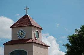 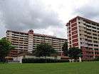 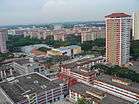 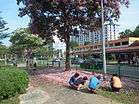     From top left to right: Clock tower of Presbyterian High School, Flats along Ang Mo Kio Street 53, Aerial view of Ang Mo Kio, Ang Mo Kio Street 52, Ang Mo Kio MRT Station, Ang Mo Kio Town Centre, Ang Mo Kio Avenue 5, Nanyang Polytechnic | |
 Ang Mo Kio Location of Ang Mo Kio within Singapore | |
| Coordinates: 1°22′12.6″N 103°50′44.23″E / 1.370167°N 103.8456194°E | |
| Country |
|
| Region |
|
| CDCs | |
| Town councils |
|
| Constituencies | |
| Town announced |
|
| Town completed |
|
| DGP exhibited |
|
| PA incorporated |
|
| Government | |
| • Mayors |
Central Singapore CDC North West CDC |
| • Members of Parliament |
Ang Mo Kio GRC Nee Soon GRC |
| Area[4][5] | |
| • Total | 13.94 km2 (5.38 sq mi) |
| Area rank | 18th |
| • Residential | 2.83 km2 (1.09 sq mi) |
| Population (2015)[4][6] | |
| • Total | 166,820 |
| • Rank | 8th |
| • Density | 12,000/km2 (31,000/sq mi) |
| • Density rank | 10th |
| Demonym(s) |
Official
Colloquial
|
| Ethnic groups[7] | |
| • Chinese | 143,290 |
| • Malays | 13,060 |
| • Indians | 14,150 |
| • Others | 4,270 |
| Postal district | 20 |
| Dwelling units | 49,169 |
| Projected ultimate | 58,000 |
Ang Mo Kio (Chinese: 宏茂桥 [xʊ̌ŋ.mâu.tɕʰjǎu]; Tamil: ஆங் மோ கியோ), often abbreviated as AMK, is a planning area and residential town situated in the North-East Region of Singapore. Ang Mo Kio is the 3rd most populated planning area in the North-East Region and ranks 8th in terms of population in the country overall.[4][7] The planning area is located at the south-western corner of the North-East Region, bordered by the planning areas of Yishun to the north, Sengkang to the north-east, Serangoon to the east, Bishan to the south and the Central Water Catchment to the west.[8]
Prior to urbanization, the area, much like other rural districts in Singapore at the time, was largely undeveloped, being mainly used for agricultural purposes, with uninhabited plots of land usually covered in dense secondary forest or swamps.[9] Ang Mo Kio was subsequently redeveloped by the Housing and Development Board in 1973 as their seventh satellite town and the first to be built in metric dimensions,[2][9][10] being fully completed by 1980. The first three town councils in the country were established in Ang Mo Kio in 1986, as part of a pilot project to better serve residents of HDB new towns. The concept eventually became adopted under the Town Council Act of 1988 which today, remains as the second-level of administration in Singapore.[11][12]
The large commercialization of the Ang Mo Kio throughout mid-1970s and 1980s also saw the rise of neighbourhood startup businesses that remain prominent throughout Ang Mo Kio Town Centre today. One in particular eventually became one of Singapore's largest supermarket chains, Sheng Siong.[2][9][13][14]
Ang Mo Kio today, much like its neighbouring towns, is largely urbanized, with little to no trace of its original ecology. However, parks are still prevalent in the town as part of the country's green initiative. Said parks include Ang Mo Kio Town Garden East and Ang Mo Kio Town Garden West. Although not technically located within Ang Mo Kio itself, Bishan-Ang Mo Kio Park in the adjacent town of Bishan, was reopened in 2012 to serve residents of both towns. The park itself straddles along the Ang Mo Kio–Bishan boundary, making it easily accessible from Ang Mo Kio.
Etymology
The name of the locality is synonymous with phrases in the Hokkien dialect which either relates it as the "Red Tomato", or the "Bridge of the Caucasian". The Caucasian suggested could be a British Lady called Lady Jennifer Windsor. Lady Windsor was the wife of Lord Windsor, a wealthy merchant who had a huge estate in the Upper Thomson Area in the 1920s until after World War II. Ang Mo Kio could also have been named in reference to Mr John Turnbull Thomson, a British civil engineer and artist who played an instrumental role in the development of the early infrastructure of late 19th century Singapore and New Zealand. Old survey maps relate the area as the "Mukim of Ang Mo Kio" (Mukim meaning "area" or "precinct" in Malay).[15] The area has also been historically referred to as Kou Teu Kio.[16]
Lady Jennifer Windsor
Lady Windsor was linked to an unnamed crossing that bridged a stream running off the Peirce Reservoir. It suggested where the name "Ang Mo Kio" might have originated. An incident happened in 1923 when Lady Windsor lost 3 of her children; Harry, Paul and Angela. The 3 children were supposed to have visited a family friend staying in the Upper Thomson area, and were lost in the woods. It was later found that the 2 boys were playing by the wooden crossing when a sudden gush swept them away. Their bodies were found about 2 miles from the bridge. However, the body of Angela was never found.
It was said that locals started hearing cries of a little girl and that prompted Lady Windsor to stay by the bridge for the rest of her life. She thought that it was a ghost. She told her close friends that she had heard her daughter's voice by the bridge and she wanted to accompany her soul. Lady Windsor would spend the whole day by the bridge, reading or knitting. People soon got used to her perpetual presence by the bridge that they soon referred to the bridge as the "Red Hair Bridge"; which in its right sense should have been called "Lady Windsor Bridge".
Lady Windsor died in 1963 and it was only thereafter that locals no longer heard the voice of the little girl.
John Turnbull Thomson
John Turnbull Thomson(1821–1884) was responsible for building a bridge during the colonial days of Singapore, to facilitate logistic transportation to the nearby British military bases at Seletar until the British military withdrawal in the 1970s. After the bridge was completed, the locals often referred to it as Ang Mo Kio or "Caucasian Bridge" or "Red Hair Bridge", since it was built by a Caucasian; John Turnbull Thomson had a distinctive red-coloured hair. Nowadays, "Ang Mo" is a popular term to refer to Caucasians in Singapore.
The name "Thomson" was also used extensively in the naming of several roads in and around Ang Mo Kio. This explanation is currently being listed at the Heritage Corridor in Deyi Secondary School located in Ang Mo Kio. The explanation is also more widely accepted by the local historians and listed in the National Library Board. The bridge, however, no longer exists. It was, according to local historians, located at the junction of Ang Mo Kio Avenue 1 and Upper Thomson Road. Little of the bridge built by Thomson remains.
Geography
Location
Ang Mo Kio Planning Area, as defined by the Urban Redevelopment Authority, sits within the North-East Region of Singapore. Yishun bounds Ang Mo Kio to the north, Sengkang to the northeast, Serangoon to the east, Bishan to the south and Central Water Catchment to the west.
The main component of the planning area, Ang Mo Kio New Town, is located within it. The town itself has seven neighbourhoods, with Neighbourhood 1 to the west, cycling in an anti-clockwise direction to Neighbourhood 6 to the north, and ending with Neighbourhood 7 for the town centre. The town centre is located in the heart of Ang Mo Kio and is sandwiched by two town gardens set on natural hillocks.
Subzones
Ang Mo Kio Planning Area is officially divided into 12 subzones for urban planning and statistical purposes.
| Name of estates | Location | Notable structures | Accessibility |
|---|---|---|---|
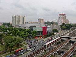
| Ang Mo Kio Town Centre | Areas around Ang Mo Kio Central 1, Ang Mo Kio Central 2 and Ang Mo Kio Central 3 | Ang Mo Kio Public Library, Ang Mo Kio Bus Interchange and AMK Hub | Ang Mo Kio MRT Station and buses |
| Cheng San | Estates along Ang Mo Kio Street 51, Ang Mo Kio Street 52, Ang Mo Kio Street 53 and Ang Mo Kio Street 54 | Ang Mo Kio MRT Station, Ang Mo Kio Town Garden East and Anderson Secondary School | Ang Mo Kio MRT Station and buses |
| Chong Boon | Southeast Ang Mo Kio | Chong Boon Secondary School, Deyi Secondary School and Pathlight School | Buses |
| Kebun Baru | Precincts west of Ang Mo Kio Town Centre | Ang Mo Kio Town Garden West, Kebun Baru Community Club, Kebun Baru Neighbourhood Police Post, CHIJ Saint Nicholas Girls' School and the future Mayflower MRT Station | Buses |
| Sembawang Hills | Estates along Sembawang Hills Drive and Thomson Hills Drive | Sembawang Hills Food Centre | Buses |
| Shangri-La | Southwest Ang Mo Kio | Mayflower Secondary School, Ang Mo Kio Primary School, Ang Mo Kio Secondary School and Ang Mo Kio Community Centre | Buses |
| Tagore | Northwest Ang Mo Kio | Teacher's Estate, Tagore Industrial Estate and the future Lentor MRT Station | Buses |
| Townsville | Areas around Ang Mo Kio Street 31 and Ang Mo Kio Street 32 | Ang Mo Kio Swimming Complex, Teck Ghee Neighbourhood Police Post and Townsville Primary School | Buses |
| Yio Chu Kang | Areas north of Ang Mo Kio Town Centre | Yio Chu Kang MRT Station, Yio Chu Kang Bus Interchange, Yio Chu Kang Stadium, Yio Chu Kang Swimming Complex, Ang Mo Kio Police Division Headquarters, Ang Mo Kio North Neighbourhood Police Post, Ang Mo Kio Fire Station, Ang Mo Kio Bus Depot (SBS Transit) and Anderson Junior College | Yio Chu Kang MRT Station and buses |
| Yio Chu Kang East | Northeast Ang Mo Kio | Nanyang Polytechnic, ITE College Central and Amoy Quee Camp | Yio Chu Kang MRT Station and buses |
| Yio Chu Kang North | Areas bounded by Seletar Expressway, Central Expressway, Yio Chu Kang Road and Lentor Avenue | Sungei Seletar Simpang Kiri | Buses |
| Yio Chu Kang West | Areas bounded by Ang Mo Kio Avenue 5, Ang Mo Kio Avenue 6 and Yio Chu Kang Road | Anderson Primary School, Presbyterian High School and Yio Chu Kang Secondary School | Yio Chu Kang MRT Station and buses |
History
Origins
The present-day Ang Mo Kio area remained largely uninhabited throughout the 19th century. Settlers were attracted to the area only around the start of the 20th century, as a result of the rubber boom. In the old maps of Singapore, much of the area was labelled as the Ang Mo Kio Forest Reserve with many plantation estates.
The village that sprang up with the clearing of the land took on the name "Ang Mo Kio". The immigrant Chinese, mostly Hokkiens were engaged in rubber-planting and tapping. Cheng San Village where Ang Mo Kio New Town now stands was once a huge rubber plantation. The 1922 to 1932 world slump in rubber prices made many tappers and labourers turn to pig and poultry farming or market gardening. During World War II when Singapore was occupied, more people moved to Ang Mo Kio to take up farming.
Today
The development of the present Ang Mo Kio Town began in 1973,[17] and was the seventh New town to be built in Singapore. The first part of Ang Mo Kio was being built by 1979, and the Yio Chu Kang part of the town was completed in 1981. The present 29 hectares (72 acres) self-contained town centre was built over an elongated valley formerly occupied by squatters. It has commercial offices, cultural and community facilities serving at least 200,000 residents.
The design of the town won the Singapore Institute of Architects (SIA) Outstanding Buildings Award in 1983. The swimming complex at Avenue 1 also won the 1986 SIA Architectural Award for its unique "tetrahedral skylight" design. It was the first town to be designed in metric measurements.
Infrastructure
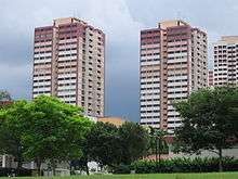
Following the norm in the 1970s, most of the flats are organised in 12-storey long blocks or 25-storey point blocks. In recent years, certain parts of the estate have been rebuilt as part of the long process of renewal. As a result, segments of higher blocks clustered together can be seen interleaved with the older blocks.
With Ang Mo Kio becoming an matured estate, several plots of residential land have been cleared up and sold to private developers for redevelopment. Many private residential projects are being constructed on these sites.
Transportation
Road network
The town's road system utilises a hierarchy of road sizes by design: the major roads are referred to as "Avenues", and the local-access roads referred to as "Streets". The town's avenues are arranged in a grid-like pattern, with the streets filtering traffic from the avenues to the individual blocks. The town itself is served by the Central Expressway, providing a rapid link from the town to the rest of the island via the expressway network.
In the town's road numbering system, avenues running from east to west are assigned odd numbers, with numbers increasing from south to north, while north-south avenues are assigned even numbers, increasing from west to east. Street numbers consist of two digits, with the first digit corresponding to the neighbourhood it belongs to and the second running in numerical sequence.[18]
Ang Mo Kio Town was the first town to introduce this road numbering system, and it has since been replicated in other towns such as Hougang, Jurong West and Woodlands. The newer towns such as Sengkang and Punggol no longer follow this system.
Mass Rapid Transit
The town is well served by a multi-modal public transport system. Two Mass Rapid Transit stations currently serve the town, both of which are on the North South Line. They are:
- NS15 Yio Chu Kang
- NS16 Ang Mo Kio
In addition, two upcoming stations on the Thomson-East Coast MRT Line will serve the new town alongside the existing stations on the North South Line. They are:
Lentor MRT station will be located at the junction between Ang Mo Kio Avenue 4 and Yio Chu Kang Road, and Mayflower MRT station will be located along Ang Mo Kio Avenue 4, within the Kebun Baru subzone. The two stations will be opened in 2020 under stage 2 and the line will parallel the North South line towards Woodlands and the city centre as well as offering direct connections to the eastern parts of Singapore.
Bus
The Ang Mo Kio Bus Interchange is directly linked to the Ang Mo Kio MRT station via an underground pedestrian walkway, and provides feeder bus services from the MRT stations to each neighbourhood. Yio Chu Kang MRT Station is also served by bus services via the Yio Chu Kang Bus Terminal sited beside the station. Both the bus interchange and terminal offers trunk bus services to connect the town with the rest of the island, including a rapid connection to the city centre in the Central Area, as well as other financial and commercial districts in the central region of Singapore, including Shenton Way, Orchard Road, Marina Centre and Marine Parade.
Amenities
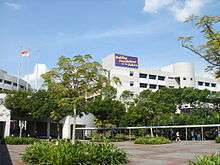
Administrative, legal, medical, religious, and social services catering towards the general public may also be found in the Ang Mo Kio area, with a major community hospital Ang Mo Kio Thye Hua Kwan Hospital that offers rehabilitative care.[19] Recreational amenities include the Ang Mo Kio Park located on a hilly area surrounded by Avenues 4, 5, and 6 and alongside Mayflower estate, and also Bishan Park along Ang Mo Kio Avenue 1 which is frequented by people from both Ang Mo Kio and Bishan estates.
Several shopping malls are also found in Ang Mo Kio Central:
- AMK Hub
- Broadway Plaza
- Djitsun Mall
Education
The area has a total of 8 MOE primary schools, 8 MOE secondary schools, Anderson Junior College, ITE College Central and Nanyang Polytechnic.[20]
Several preschools can be found in Ang Mo Kio including the Al-Muttaqin Mosque Kindergarten, childcare centres operated by the National Trades Union Congress named My First Skool and also kindergartens managed under the PAP Community Foundation. Two special schools may also be found, Chaoyang School (APSN) which caters for children with mild intellectual disability aged 7–12 years old,[21] and Pathlight School with two campuses in Ang Mo Kio with a focus on autism.[22]
Politics
The jurisdiction of the area has been largely handled by Ang Mo Kio Town Council which oversees Ang Mo Kio Group Representation Constituency since 1991. Another constituency has assumed control over part of Ang Mo Kio which is Nee Soon Group Representation Constituency for the Kebun Baru division. The current Prime Minister of Singapore, Lee Hsien Loong, is a member of Ang Mo Kio Town Council and the constituency of the same name.
Previously, the Cheng San Group Representation Constituency from 1988 to 2001 have handled parts of Ang Mo Kio such as Cheng San, Chong Boon and Jalan Kayu. Chong Boon was transferred to Ang Mo Kio GRC in 1997. Yio Chu Kang Single Member Constituency have handled parts of Ang Mo Kio from 2006 to 2011.
References
- ↑ "The next new town: Ang Mo Kio". The Sunday Times. 5 August 1973.
- 1 2 3 "Singapore Infopedia: Ang Mo Kio". National Library Board.
- 1 2 "Singapore Infopedia - Development guide plan". National Library Board.
- 1 2 3 City Population - statistics, maps and charts | Ang Mo Kio
- ↑ HDB Key Statistics FY 2014/2015 Archived 4 March 2016 at the Wayback Machine.
- ↑ "Land Area and Dwelling Units by Town". Data Singapore. 2016. Retrieved January 26, 2018.
- 1 2 "Singapore Residents by Planning Area/Subzone, 2015" (XLS). Singapore Department of Statistics.
- ↑ Singapore Department of Statistics - Planning Areas/Subzones in Singapore (Year 2015)
- 1 2 3 National Heritage Board. Ang Mo Kio Heritage Trail
- ↑ "Now metric for HDB flats". The Straits Times. 11 March 1974.
- ↑ "HDB Towns, Our Home: Ang Mo Kio". Housing and Development Board.
- ↑ "Singapore Infopedia: Singapore's first town councils". National Library Board.
- ↑ Chan, F (2009-06-10). "From pig farmer to supermarket chain owner". The Straits Times. Retrieved from NewspaperSG. Retrieved 17 February 2015.
- ↑ "Singapore Infopedia: Sheng Siong". National Library Board. Archived from the original on 14 September 2011.
- ↑ "An early surveyor in Singapore : John Turnbull Thomson in Singapore, 1841–1853 / John Hall-Jones, Christopher Hooi". Retrieved 20 November 2013.
- ↑ "HDB Towns, Your Home - Ang Mo Kio". Housing and Development Board.
- ↑ "Ang Mo Kio, My Hometown of 25 years". Retrieved 20 November 2013.
- ↑ "Map of Ang Mo Kio Avenue 1, Ang Mo Kio Avenue 3/5, Ang Mo Kio Avenue 6/8, Central Expressway (CTE) and Bishan Park in Singapore". Retrieved 20 November 2013.
- ↑ "Ang Mo Kio – Thye Hua Kwan Hospital". Retrieved 20 November 2013.
- ↑ School Information Service
- ↑ "Chaoyang School". Retrieved 20 November 2013.
- ↑ "Pathlight School". Retrieved 20 November 2013.