Andaç, Uludere
| Andaç Halmon | |
|---|---|
| Village | |
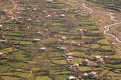 The village in springtime. | |
 Andaç Location in Turkey | |
| Coordinates: 37°21′22″N 43°15′38″E / 37.35611°N 43.26056°ECoordinates: 37°21′22″N 43°15′38″E / 37.35611°N 43.26056°E | |
| Country |
|
| Province | Şırnak |
| District | Uludere |
| Government | |
| • Headman | Edis İzettin |
| Elevation | 1,330 m (4,360 ft) |
| Population (2012) | |
| • Total | 2,960 |
| Time zone | UTC+2 (EET) |
| • Summer (DST) | UTC+3 (EEST) |
| Area code(s) | 0482 |
| Licence plate | 47 |
Andaç is a village in the district of Uludere in Sirnak province, in southeastern Turkey.[1] The village is around 48 kilometres (30 mi) away from the district of Uludere and it is located in southeastern Turkey, just on the western border of the Hakkari province. The village was an ancient Assyrian settlement and was part of Assyria.
History
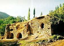
The former name of the village is Halmon, which had Assyrian people living there since the 6th century. There are two intact Syriac churches still in the village and a large number of house ruins on the upper part in the Yarma village (Gérāmon), which is currently part of Andaç. Lying to the west of Tyari, the village is known to have been the birthplace of the Bishop Mār Ṭūrīs of Māḥozé d-Aryon, who lived in the early 7th century. Additionally, the history of Rabbān Yawsip Busnāyā records the presence of Syriac Christians at Halmon, during the mid-10th century.[2]
Prior to Seyfo in 1915, Halmon was a purely Assyrian settlement comprising over 60 households, with a 4th-century church dedicated to St. Shmuni. The Assyrians of Halmon were settled in the village of Cham-Suske, in the Dohuk province of northern Iraq, in 1922. Later on, they were resettled in the village of Tell-Jum'ah, along the Khabur River in Syria, in 1935.
To the east, Geramon was another Assyrian village home to more than 80 households, with a 6th-century church dedicated to St. John the Arab. From 1922 onward, the Assyrians of Geramon were resettled in northern Iraq.[3]
Geography
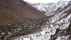
Bordering Northern Iraq and within the upper reaches of Mesopotamia, the village sits between high mountains and is situated within a valley. There is a river nearby. The village has a dry-summer humid continental climate. Summers are hot and virtually dry with maximum temperatures reaching over 33 °C and winters being cold and wet, where maximum temperatures hover around 4 °C. Snowfall is common in winter and rainfall is more pronounced in spring. The area's vegetation is Mediterranean forests, woodlands, and scrub, but more temperate grassland in the upper areas. The Assyrian village of Gérāmon (Yarma) is less than 1 kilometre (0.62 mi) to the east and is usually incorporated within Andaç with the area being designated as Andaç-Yarma.
Population
| Village population | |
|---|---|
| 2012 | 2,906 |
| 2007 | 2,504 |
| 2000 | 2,165 |
| 1990 | 1,226 |
Economy
The economy of the village is based on agriculture and animal husbandry. In addition to the settlement, labor and temporary village guards are being built.
Infrastructure
There are three primary schools in the village and one secondary school called Andaç Yarma Intermediate School. The water network of the village is available and there is no sewer network. There is no PTT branch and agency. There is a health center and a health home. The area is known for its asphalt. There is electricity and fixed telephone in the village.
