Nimrod Fortress
| Nimrod Fortress | |
|---|---|
|
قلعة الصبيبة מבצר נמרוד | |
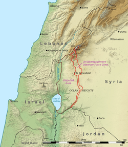
| Golan Heights | |
 | |
 Nimrod Fortress | |
| Coordinates | 33°15′10″N 35°42′53″E / 33.252778°N 35.714722°E |
| Type | Castle |
| Site information | |
| Open to the public |
April–September: 8 a.m. – 5 p.m. October–March: 8 a.m. – 4 p.m. |
| Site history | |
| Built | Between 1229 and 1290[1] |
| Built by | Al-Aziz Uthman |
The Nimrod Fortress or Nimrod Castle (Arabic: قلعة الصبيبة Qal'at al-Subeiba, "Castle of the Large Cliff", later Qal'at Namrud, "Nimrod's Castle"; Hebrew: מבצר נמרוד, Mivtzar Nimrod, "Nimrod's Fortress") is a medieval Ayyubid castle situated on the southern slopes of Mount Hermon, on a ridge rising about 800 m (2600 feet) above sea level. It overlooks the Golan Heights and was built with the purpose of guarding a major access route to Damascus against armies coming from the west.
Alternative forms and spellings include: Kal'at instead of Qal'at, the prefix as- instead of al-, and Subayba, Subaybah and Subeibeh in place of Subeiba.
The area is under Israeli occupation and administration since 1967 together with the adjacent Golan Heights. The international community sees the area as Syrian territory.
History
The fortress was built around 1229 by Al-Aziz Uthman, the younger son of Saladin, to preempt an attack on Damascus by the armies of the Sixth Crusade. It was named Qal'at al-Subeiba, "Castle of the Large Cliff" in Arabic. The fortress was further expanded to contain the whole ridge by 1230. In 1260 the Mongols captured the castle, dismantled some of its defenses and left their ally, the son of Al-Aziz 'Uthman, in charge of it and the nearby town of Banias.[2] After the subsequent Mamluk victory over the Mongols at the Battle of Ain Jalut, Sultan Baibars strengthened the castle and added larger towers. The fortress was given to Baibars's second-in-command, Bilik. The new governor started the broad construction activities. When the construction was finished, Bilik memorialized his work and glorified the name of the sultan in a 1275 inscription. After the death of Baibars, his son arranged for Bilik to be murdered, apparently because he feared his power.
At the end of the 13th century, following the Muslim conquest of the port city of Acre (Akko) and the end of Crusader rule in the Holy Land, the fortress lost its strategic value and fell into disrepair.
The Ottoman Turks conquered the land in 1517 and used the fortress as a luxury prison for Ottoman nobles. The fortress was abandoned later in the 16th century and local shepherds and their flocks were the sole guests within its walls.
The fortress was ruined by an earthquake in the 18th century.
Druze who came to the region during the 1860 conflict between themselves and the Maronites began calling it Qal'at Namrud (Nimrod's Castle).[3]
Description
The entire fortress complex is 420 m (1350 feet) in length and 150 m (500 feet) in width, and is built of large, carefully squared stones. Along the walls are numerous rectangular and semi-circular towers, roofed with pointed cross-arches.
Overlooking the high, eastern edge of the fortress stood a large keep, measuring 65 by 45 metres (200 by 150 feet) and protected by massive rectangular towers.
The fortress overlooks the deep, narrow valley that separates Mount Hermon from the rest of the Golan Heights, the road linking the Galilee with Damascus, and the former Crusader town of Banias.

Current condition
Today the site is administered by the Israel Nature and Parks Authority and visitors can explore the excavated and restored portions of the fortress.
The entrance to the fortress is from the west, and the first section contains "secret corridors"—winding staircases and underground water cisterns with some of the original plaster still visible. There are many examples of "loopholes" in fortress—special windows that are narrow on the outside but wide on the inside. They were designed specifically for shooting bows and arrows or crossbows, giving the defender inside the fortress plenty of room but the attacker only a narrow slit as a target. The central part, which is accessible by a path within the fortress, contains the remains of a keep surrounded by large rectangular towers. In the western section, there are the remains of a fortress within a fortress, which was protected by its own moat and drawbridge. This is the oldest part of the castle, which was built the first.
The park entrance is located on Route 989 between Kiryat Shmona and Mount Hermon, about twenty minutes east of Kiryat Shmona.
Nimrod, an Israeli settlement, is located nearby.
In the Israeli film Beaufort, the castle substituted for Beaufort Castle, which is located in southern Lebanon.
Gallery
.jpg) Nimrod Fortress - view towards the keep
Nimrod Fortress - view towards the keep.jpg) Nimrod Fortress - cistern
Nimrod Fortress - cistern.jpg) Nimrod Fortress - cistern
Nimrod Fortress - cistern.jpg) Nimrod Fortress - room with door, loophole
Nimrod Fortress - room with door, loophole.jpg) Nimrod Fortress - room with loophole
Nimrod Fortress - room with loophole
References
- ↑ Devir, Ori, Off the Beaten Track in Israel, Adama Books (New York, 1989), p. 16 ISBN 0-915361-28-0.
- ↑ Reuven Amitai-Preiss (2005). Mongols and Mamluks: The Mamluk-Ilkhanid War, 1260–1281. Cambridge Studies in Islamic Civilization. Cambridge: Cambridge University Press. pp. 32–33. ISBN 9780521522908. Retrieved 3 April 2015.
- ↑ Sharon, Moshe (1999). Corpus Inscriptionum Arabicarum Palaestinae: B v. 1 (Handbook of Oriental Studies) (Hardcover ed.). Brill Publishers. p. 59. ISBN 90-04-11083-6.
- Kennedy, Hugh (2000). Crusader Castles. Cambridge University Press. ISBN 0-521-79913-9.
External links
| Wikimedia Commons has media related to Nimrod Fortress. |
- Nimrod Fortress park at Israel Nature and Parks Authority (in English)
- Nimrod Fortress park at Israel Nature and Parks Authority (in Hebrew)