Mount Hermon
| Mount Hermon | |
|---|---|
|
Arabic: Jabal ash-Shaykh Hebrew: Har Hermon | |
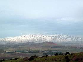 Mount Hermon, viewed from Mount Bental in the Golan Heights | |
| Highest point | |
| Elevation | 2,814 m (9,232 ft) |
| Prominence | 1,804 m (5,919 ft) |
| Listing |
Country high point Ultra |
| Coordinates | 33°24′58″N 35°51′27″E / 33.41611°N 35.85750°ECoordinates: 33°24′58″N 35°51′27″E / 33.41611°N 35.85750°E |
| Geography | |
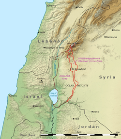 Mount Hermon Mount Hermon's summit straddles the border between Lebanon and Syria. | |
| Location |
Syria (southern slopes are located in the Israeli-occupied Golan Heights) Lebanon |
| Parent range | Anti-Lebanon mountain range |
Mount Hermon (Arabic: جبل الشيخ or جبل حرمون / ALA-LC: Jabal al-Shaykh ("Mountain of the Sheikh") or Jabal Haramun; Hebrew: הר חרמון, Har Hermon) is a mountain cluster constituting the southern end of the Anti-Lebanon mountain range. Its summit straddles the border between Syria and Lebanon[1] and, at 2,814 m (9,232 ft) above sea level, is the highest point in Syria.[2] On the top, in the United Nations buffer zone between Syrian and Israeli-occupied territories, is the highest permanently manned UN position in the world, known as "Hermon Hotel".[3] The southern slopes of Mount Hermon extend to the Israeli-occupied portion of the Golan Heights, where the Mount Hermon ski resort is located.[4] A peak in this area rising to 2,236 m (7,336 ft) is the highest elevation in Israeli-controlled territory.
Etymology
The Hebrews called the mountain "Hermon", meaning "sacred",[5] while the Amorites referred to it as "Šeni'r".[6] Another name of the mountain is "Sirion"[7] (Hebrew: שִׂרְיֹ֑ן Širyôn,[note 1] meaning "breastplate"),[note 2][10][11] the name that the Phoenicians (especially Sidonians) gave to Mount Hermon,[12] from which the term "Syria" might be derived.
Geography
Mount Hermon is a cluster of mountains with three distinct summits, each about the same height. The antilibanos (anti-Lebanon range), of which the Hermon range constitutes the southernmost part, extends for approximately 150 km (93 mi) in a northeast-southwest direction, running parallel to the Lebanon range on the west. The Hermon range covers an area of about 700 km2 (270 sq mi) of which about 70 km2 (27 sq mi) are under Israeli control. Most of the portion of Mount Hermon within the Israeli-controlled area constitutes the Hermon nature reserve. The entire relatively narrow range, with the Lebanon-Syria boundary along its spine, extends from 25km northeast of Mt. Hermon to 45km southwest of it.[13][14]
The mountain forms one of the greatest geographic resources of the area. Because of its height it captures a great deal of precipitation in a very dry area of the world. The Jurassic limestone is broken by faults and solution channels to form a karst topography. Mount Hermon has seasonal winter and spring snow falls, which cover all three of its peaks for most of the year. Melt water from the snow-covered mountain's western and southern bases seeps into the rock channels and pores, feeding springs at the base of the mountain, which form streams and rivers. These merge to become the Jordan River. Additionally, the runoff facilitates fertile plant life below the snow line, where vineyards and pine, oak, and poplar trees are abundant.[15]
The springs, and the mountain itself, are much contested by the nations of the area for the use of the water. Mount Hermon is also called the "snowy mountain," the "gray-haired mountain", and the "mountain of snow". It is also called "the eyes of the nation" in Israel because its elevation makes it Israel's primary strategic early warning system.[16][17]
Epigraphy, archaeology and references in religious texts
The Epic of Gilgamesh mentions that Mount Hermon split after Gilgamesh killed Humbaba, the Guardian of the Cedar Forest. One translation of Tablet V states, "The ground split open with the heels of their feet, as they whirled around in circles Mt. Hermon and Lebanon split."[18]
In the Book of Enoch, Mount Hermon is the place where the Watcher class of fallen angels descended to Earth. They swear upon the mountain that they would take wives among the daughters of men and take mutual imprecation for their sin (Enoch 6). The mountain or summit is referred to as Saphon in Ugaritic texts where the palace of Ba'al is located in a myth about Attar.[19][20] The Book of Chronicles also mentions Mount Hermon as a place where Epher, Ishi, Eliel, Azriel, Jeremiah, Hodaviah, and Jahdiel were the heads of their families.[21] R.T. France, in his book on the Gospel of Matthew, noted that Mount Hermon was a possible location of the Transfiguration of Jesus.[22][23]
Various Temples of Mount Hermon can be found in villages on the slopes. There is a sacred building made of hewn blocks of stone on the summit of Mount Hermon. Known as Qasr Antar, it is the highest temple of the ancient world and was documented by Sir Charles Warren in 1869. An inscription on a limestone stele recovered by Warren from Qasr Antar was translated by George Nickelsburg to read "According to the command of the greatest a (nd) Holy God, those who take an oath (proceed) from here." Nickelsburg connected the inscription with oath taken by the angels under Semjaza who took an oath together, bound by a curse, in order to take human wives in the Book of Enoch (1 Enoch 6:6). Hermon was said to have become known as "the mountain of oath" by Charles Simon Clermont-Ganneau. The name of God was supposed to be a Hellenized version of Baʿal or Hadad and Nickelsburg connected it with the place name of Baal-Hermon (Lord of Hermon) and the deity given by Enoch as "The Great Holy One".[24] The mountain was said to have become known as "the mountain of oath" by Charles Simon Clermont-Ganneau. Eusebius recognized the religious importance of Hermon in his work Onomasticon, saying "Until today, the mount in front of Banias and Lebanon is known as Hermon and it is respected by nations as a sanctuary". It has been related to the Arabic term al-haram, which means "sacred enclosure".[25] Another Greek inscription found in a large temple at Deir El Aachayer on the northern slopes notes the year that a bench was installed "in the year 242, under Beeliabos, also called Diototos, son of Abedanos, high priest of the gods of Kiboreia". The era of the gods of Kiboreia is not certain, nor is their location, which is not conclusively to be identified with Deir al-Achayer, but was possibly the Roman sanctuary or the name of a settlement in the area.[26]
In Psalm 42, which leads the Psalms of the northern kingdom, the Psalmist remembers God from the land of Jordan and the Hermonites. In Song of Songs 4:8, Hermon is an instance of an exotic locale, and Psalm 133, one of the Songs of Ascents, makes specific reference to the abundant dew formation upon Mount Hermon.[27]
According to the controversial research by Professor Israel Knohl of the Hebrew University, in his book "Hashem", Mount Hermon is actually the Mount Sinai mentioned in the bible, with the biblical story reminiscent of an ancient battle of the northern tribes with the Egyptians somewhere in the Jordan valley or Golan heights.[28]
Climate
| Climate data for Hermon (1640 meters above sea level) | |||||||||||||
|---|---|---|---|---|---|---|---|---|---|---|---|---|---|
| Month | Jan | Feb | Mar | Apr | May | Jun | Jul | Aug | Sep | Oct | Nov | Dec | Year |
| Average high °C (°F) | 3.3 (37.9) |
4.0 (39.2) |
7.6 (45.7) |
12.0 (53.6) |
16.0 (60.8) |
19.4 (66.9) |
21.6 (70.9) |
21.7 (71.1) |
19.1 (66.4) |
15.3 (59.5) |
10.2 (50.4) |
5.1 (41.2) |
12.9 (55.3) |
| Daily mean °C (°F) | 1.2 (34.2) |
1.9 (35.4) |
4.1 (39.4) |
7.5 (45.5) |
11.2 (52.2) |
14.5 (58.1) |
16.8 (62.2) |
16.7 (62.1) |
14.3 (57.7) |
11.2 (52.2) |
7.0 (44.6) |
3.3 (37.9) |
9.1 (48.5) |
| Average low °C (°F) | −2.2 (28) |
−3.1 (26.4) |
0.6 (33.1) |
3.1 (37.6) |
6.4 (43.5) |
9.6 (49.3) |
12.0 (53.6) |
11.8 (53.2) |
9.5 (49.1) |
7.2 (45) |
2.7 (36.9) |
−0.5 (31.1) |
4.8 (40.6) |
| Average rainfall mm (inches) | 300.3 (11.823) |
250.4 (9.858) |
138.8 (5.465) |
100.2 (3.945) |
30.2 (1.189) |
7.5 (0.295) |
1.7 (0.067) |
0.9 (0.035) |
10.4 (0.409) |
110.6 (4.354) |
175.3 (6.902) |
226.5 (8.917) |
1,352.8 (53.259) |
| Average rainy days | 20.8 | 19.3 | 11.5 | 8.8 | 5.8 | 2.3 | 0.7 | 0.6 | 3.5 | 11.2 | 15.5 | 18.9 | 118.9 |
Arab-Israeli conflict
During the Six-Day War in June 1967, a part of Mount Hermon in Syria was captured by Israel. It was regained by Syria on October 6, 1973, the first day of the Yom Kippur War, following the First Battle of Mount Hermon. Israel recaptured both the formerly Israeli-occupied sector and the pre-Yom Kippur War Syrian-controlled sector on October 21, 1973, during Operation Dessert.[29] The pre-Yom Kippur War Syrian-controlled sector was returned to Syria after the war.[30]
The Israeli-occupied sector of the mountain became patrolled by the Israel Defense Forces and the Israel Police, and the Israeli Security Forces have maintained a strategic observation post for monitoring Syrian and Lebanese military activity near Mitzpe Shlagim ("Snow Lookout"), which is at an elevation of about 2,224 m (7,300 ft). Its neighboring peak, at 2,236 m (7,336 ft), is the highest elevation in Israeli-occupied territory.[31]
Since the onset of Syrian Civil War, the Syrian-controlled Hermon has continued to be under pro-Assad forces, though clashes have sporadically erupted on the mountain range and spilled into Lebanon and the Israeli-occupied portion. Most notably the Islamist rebel factions of Jaish al-Haramoun took part in the fighting on the Southern slopes of the mountain.
Ski resort
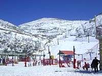
Since 1981, when the Golan Heights Law was passed, the Israeli-occupied portion of the Golan Heights has been governed under Israeli law. Mount Hermon hosts the only ski resort in territory held by Israel, including a wide range of ski trails at novice, intermediate, and expert levels. It also offers additional winter family activities such as sledding and Nordic skiing. Those who operate the Hermon Ski area live in the nearby Israeli settlement of Neve Ativ and the Druze town of Majdal Shams. The ski resort has a ski school, ski patrol, and several restaurants located at either the bottom or peak of the area. In 2005, the Syrian government had plans to develop a 15-billion-dollar ski resort on the slopes of the mountain.[32]
See also
Notes
References
- ↑ "ACME Mapper terrain display". mapper.acme.com. Retrieved 28 March 2016.
- ↑ "CIA World Fact Book: Syria". 14 November 2011. Retrieved 27 November 2011.
highest point: Mount Hermon 2,814 m
- ↑ Gröppel, Ekkehard (April–June 2013). "It is time to say Goodbye!" (PDF). Golan: The UNDOF Journal. United Nations Disengagement Observer Force (135): 10–15. Retrieved 15 July 2015.
- ↑ The World's 18 Strangest Ski Resorts: The Mount Hermon Ski Resort, Shannon Hassett, Popular Mechanics
- ↑ Jan N. Bremmer (2003). The Apocalypse of Peter. Peeters Publishers. p. 76. ISBN 9789042913752.
- ↑ Sir William Smith (1863). A Dictionary of the Bible: Red-Sea-Zuzims. Princeton University. p. 1195.
- ↑ Nissim Raphael Ganor (2009). Who Were the Phoenicians?. Kotarim International Publishing. p. 252. ISBN 9659141521.
- ↑ 8280. sarah, biblehub.com
- ↑ Christoph Luxenberg (2007). The Syro-Aramaic Reading of the Koran: A Contribution to the Decoding of the Language of the Koran. Hans Schiler. p. 9. ISBN 9783899300888.
- ↑ "Sirion". Retrieved 18 October 2017.
- ↑ "Hebrew: שִׁרְיוֹן, širyôn (H8303)". Retrieved 19 October 2017.
- ↑ Pipes, Daniel (1992). Greater Syria: The History of an Ambition. Middle East Forum. p. 13. ISBN 0-19-506022-9. Retrieved 1 February 2010.
- ↑ The Hermon entry area Israeli Liberary of Technology for Education (in Hebrew)
- ↑ The Hermon Shoulder Israeli Ministry of Environment website (in Hebrew)
- ↑ The vegetation of Mount Hermon Mike Livneh (In Hebrew, Israel Mofet Unit of Research and Development, Dept. Of Education)
- ↑ If UN positions on Syria border fall to radicals Israel will have to respond Yacov Lapin, January 13, 2016 (Jerusalem Post)
- ↑ The Eyes of the Country have Closed Death of the soldier who coined the term "The eyes of the country" for a battle on the Hermon Mountain (in Hebrew, Ynet, 30 November 2006)
- ↑ Kovacs, Maureen (1989). The Epic of Gilgamesh. Stanford, California: Stanford University Press. p. 43. ISBN 0804715890.
- ↑ John C. L. Gibson; Nick Wyatt; Wilfred G. E. Watson; Jeffery B. Lloyd (1996). Ugarit, religion and culture: proceedings of the International Colloquium on Ugarit, religion and culture, Edinburgh, July 1994 : essays presented in honour of Professor John C.L. Gibson. Ugarit-Verlag. ISBN 978-3-927120-37-2. Retrieved 20 June 2011.
- ↑ Manfried Dietrich; Oswald Loretz (1996). Ugarit-Forschungen, p. 236. Verlag Butzon & Bercker. ISBN 978-3-7887-1588-5. Retrieved 20 June 2011.
- ↑ 1 Chronicles 5:23-24
- ↑ R.T. France, Matthew: An Introduction and Commentary (Tyndale New Testament Commentaries) (IVP Academic, 2008)
- ↑ Harrington, Daniel (1991). Sacra Pagina: The Gospel of Matthew. Collegeville, Minnesota: The Liturgical Press. p. 253. ISBN 0-8146-5803-2.
- ↑ Nickelsburg, 1 Enoch 1. A Commentary on the Book of 1 Enoch, 1–36; 81–108 (Minneapolis: Fortress, 2001.
- ↑ E. A. Myers (11 February 2010). The Ituraeans and the Roman Near East: Reassessing the Sources. Cambridge University Press. pp. 65–. ISBN 978-0-521-51887-1. Retrieved 18 September 2012.
- ↑ Fergus Millar (1993). The Roman Near East, 31 B.C.-A.D. 337. Harvard University Press. pp. 311–. ISBN 978-0-674-77886-3. Retrieved 18 September 2012.
- ↑ Clifford, Richard J. (1 November 2003). Abingdon Old Testament Commentaries: Psalms 73-150. Abingdon Press. pp. 263–264. ISBN 978-1-4267-6009-9.
“Hermon” is an instance of an exotic locale, as in Song 4:8, where it occurs with several other place names. Mount Hermon was famous for its heavy dew. Though the Mediterranean climate of Palestine had no rainfall from May or June to September, it had dew. Dew was important in the summer and a supplement to rain. Zion was therefore a place of fertility which even in the rainless season has an abundance of dew, like that of mighty Hermon to the north. So plentiful is it that it “runs down [NRSV: “falls on”] the mountains of Zion” (Ps 133:3).
- ↑ Pharaoh’s War with the Israelites: The Untold Story Israel Knohl, Azure Magazine #41, Summer 2010 (Azure Magazine website)
- ↑ "The Yom Kippur War". Ynetnews. 2008-11-11. Retrieved 24 November 2008.
- ↑ "Syria". Ynetnews. 2007-12-23. Retrieved 25 November 2008.
- ↑ Cordesman, Anthony H. (2008). Israel and Syria. USA: Center for Strategic and International Studies. p. 222. ISBN 978-0-313-35520-2. Retrieved 2 September 2011.
Its adjacent peak, at 2,236 meters, is the highest elevation in Israel.
- ↑ "Syria unveils 15 billion dollar tourism project". Middle East Online. Dec 20, 2005.
External links
| Wikivoyage has a travel guide for Mount Hermon. |

