Khirbat al-Minya
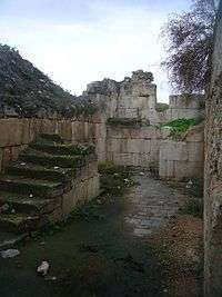 The ruins of the Minya palace, 2009 | |
 Shown within Israel | |
| Alternative name | Ayn Minyat Hisham, Hurvat Minim |
|---|---|
| Coordinates | 32°51′54″N 35°32′10″E / 32.864884°N 35.536223°E |
| Grid position | 200/252 PAL |
| Type | palace |
| History | |
| Builder | Umayyad ruler |
| Founded | 8th century |
| Abandoned | 8th century, later reused |
| Site notes | |
| Public access | Yes |
Khirbat al-Minya (also known as Ayn Minyat Hisham or Hurvat Minim) is an Umayyad-built palace in the eastern Galilee, Israel, located about 200 meters (660 ft) west of the northern end of Lake Tiberias.[1] It was erected as a qasr complex, with a palace, mosque, and bath built by a single patron.[2]
The site is the only Umayyad ruin in Israeli territory with remains above the ground and features one of the earliest mosques in Palestine.
History
Construction
Khirbat al-Minya was likely built during the reign of the Umayyad caliph al-Walid I (705-715 CE) and an inscription on a stone found at the site mentions his name. The supposed patron of the palace was al-Walid's son 'Umar ibn al-Walid, who served as the governor of Tiberias during his father's reign, but fell out of favor when his uncle Sulayman ibn Abd al-Malik assumed the role of caliph.[2] This makes the palace's mosque one of the earliest to be built in Palestine.[3]:16
Khirbat al-Minya served a number of purposes, including as local administrative center for a subregion of the Jund al-Urdunn ("District of Jordan") and as a contact point for 'Umar and local Arab tribes. It also could have served as a caravanserai for merchants traveling along the Sea of Galilee or northeast from the lake shore to the coast. Another purpose of Khirbat al-Minya was a winter retreat for the governor of Tiberias or an alternative for the traditional summer retreat for the governor at Baysan.[2]
Khirbat al-Minya was abandoned at an uncertain date, but was later temporarily resettled.[1] There is evidence that the palace was in use until at least the end of the Umayyad period in 750 CE. A strong earthquake hit the region, probably in the 749 Galilee earthquake. This damaged the building, causing a rift to run through the eastern wing, going straight through the mosque's mihrab. The damage in the niche were never repaired. It thus remains uncertain whether the palace was ever finished: Fallen debris from the earthquake was discovered in the 20th century in situ on the floor tiles of the main entry. The unused raw materials of a mosaic builder were found in the antechamber of the mosque.[3]:17
Moreover, based on the stratification established in the western part of the site and the discovery of Mamluk pottery in 1959, the palace was settled again during the late Mamluk period (14th-15th centuries).[1][4] It is likely that the building was used as a khan in this period, due to its position at a cross-road between the main Damascus-Cairo (Via Maris) route and a secondary route to Safad via Khan Jubb Yusuf. A Khan al-Minya was constructed 300 m due north of the palace by Saif al-Din Tankiz (reigned 1312-1340), the Mamluk governor of Syria, during the reign of Al-Nasir Muhammad.[5][6][7] Parts of Khirbat al-Minya might have been used as building material for the new khan; baked bricks and a marble capital found during excavations of the khan were assumed to be taken from the palace.[6]
In 1596 it appeared under the name of Mina (Minya) in the Ottoman tax registers as part of the nahiya (subdistrict) of Jira in the Sanjak (district) of Safad. It had an all Muslim population, consisting of 110 households and 2 bachelors, all Muslim. They paid a fixed tax rate of 25 % on agricultural products, such as wheat, barley, vegetable and fruit garden, orchard, special products, beehives, water buffaloes, in addition to occasional revenues, marked toll and a water mill; totalling 26,476 akçe. All of the revenue went to a waqf for Madrasa Tahiriyya in Quds Sarif.[8][9]
Parts of the ruin were used as a water reservoir (likely for a mill) and later a large brick oven was built in the south wing and used to process sugar cane from nearby plantations. In the 19th century locals built huts on the rubble heaps.[3]:17
Modern rediscovery
In the second half of the 19th century, Charles William Wilson and other European travelers discovered ancient ruins among the huts of a local Fellah settlement. Some thought it to be Capernaum, where according to the New Testament Jesus had taught at the local synagogue. This was likely an argument for the purchase of the area along with nearby Tell el-Oreme, by the Deutscher Verein vom Heiligen Lande, a Catholic society from Germany, in 1895. After the true Capernaum synagogue was discovered in 1904, Andreas Evaristus Mader (1881-1949), an archeologist and Salvatorian patre conducted exploratory excavations at the ruin and its environments on behalf of the Görres Society in 1911-4 and again in 1931. Identifying a large quadratic structure with outer walls and corner towers, he thought it to be a Roman fort or castrum.[3]:14

This was corrected by further work by Alfons Maria Schneider and Oswin Puttrich-Reignard in 1932-9. The outbreak of World War II terminated German archaeological work in Palestine. At that point, Schneider and Puttrich-Reignard had excavated about half of the palace and published some of their findings. By 1937, they had uncovered the mosque and it had become obvious that the building was an early Islamic palace. The findings were evenly distributed between the Museum für Islamische Kunst at Berlin and the Palestine Archaeological Museum in Jerusalem (today the Rockefeller Museum). Whilst most of the findings left in Palestine have today been lost, the Berlin pieces remain in the care of the Prussian Cultural Heritage Foundation, and some of them are exhibited in the museum's permanent exhibition. The notes and drawings from the excavations are likewise kept in Berlin and have been the subject of recent studies by archaeologists from the universities of Berlin and Bamberg.[1][3]:14–15[10]
During July–August 1959, the western section of the palace was excavated by O. Grabar in collaboration with the Israel Antiquities Authority.[1] In 1960 the site was excavated by an Israeli-American expedition, intending to refine the chronology and the plan of the palace.[11] Several rescue digs were later conducted by the Israeli Antiquities Authority in the environments of the palace, revealing a bath from late antiquity/early Islamic times (1963), a medieval caravanserai (1988) and the remains of a medieval settlement between the palace and the lake (2011).[3]:15
With the reproachment between Israel and Germany in the 1960s, the Verein was reinstated as owner but handed over its rights to the palace itself to the Israel Nature and Parks Authority, which awarded the area protected status as a listed monument and has since been responsible for the palace's upkeep.[3]:15
In 2000, it was proposed that Khirbat al-Minya should become a World Heritage Site.[12]
In 2001, a study by the Getty Conservation Institute found severe structural damage to the ruin, caused by the climate and by vegetation. A lack of funds has since prevented countermeasures as well as investment in making the area more accessible to visitors.[3]:15–16
Architecture
The palace of Khirbat al-Minya is contained within an irregular rectangular enclosure (66 by 73 meters) oriented north-south,[4] facing the four cardinal points.[1][4] Like other Umayyad palaces it has round towers at its corners and semi-circular towers in the middle of each wall except the eastern wall where a monumental entrance was located.[2] The main gate in the middle of the eastern wall is formed by two projecting half-round towers separated by the arch of the gateway.[4]
The center of the structure is occupied by a colonnaded courtyard with twin staircases giving access to an upper floor level.[4] The rooms which surrounded the courtyard differ in size and arrangement and included a mosque, numerous rooms with mosaics, and a throne room.[1][2] The mosque is located in the southeastern corner and is divided into twelve bays supported on piers. Next to the mosque is a triple-aisled basilica hall. Like other Umayyad desert or country palaces, such as Qasr al-Heer al-Gharbi in the Syrian Desert and Khirbat al-Mafjar near Jericho, Khirbat al-Minya followed the Umayyad model of a five-room bait ("house"),[13] flanking the basilica hall.[1] To the north are the residential quarters.[4]
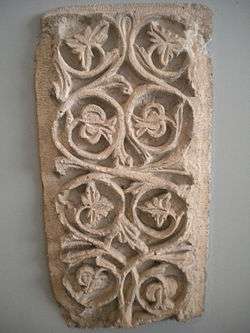
The building is constructed of finely dressed limestone blocks laid in regular courses with a lower course of black basalt stones.[4] The mosque had a simple decoration, but the domed gateway chamber and the southern rooms were richly decorated.[1] The top of the walls were decorated with large stepped merlons and the interior was decorated with a variety of glass and stone mosaics.[4] Marble panels covered the dadoes of the walls and stone mosaics combined with glass cubes were set in geometric carpet-like patterns on the floors of the five southern rooms. A well-preserved floor mosaic has been discovered in the western part of the palace.[1] Based on the foundations of the gate house, parts of the palace were at least 15 metres high.[3]:16
Today
The Israel Nature and Park Authority has erected a sign at the site which states that the protected monument was an early Islamic palace built by Al-Walid I or Al-Walid II. Its unique status, as the only Umayyad-built palace with remains above the ground in Israel, has resulted in efforts to maintain and restore the ruins and to make them more accessible to visitors. In 2012, the Institut für Vor-und Frühgeschichte of the University of Mainz, in cooperation with the Deutscher Verein vom Heiligen Lande presented a plan to the Israeli authorities. A guide was published and with financial support from the German Foreign Ministry, the University is currently working with the National Park Authority and the Israel Antiques Authority to protect the masonry from further damage.[3]:16,18–19
See also
References
- 1 2 3 4 5 6 7 8 9 10 Singh, Nagendra Kumar (2000). International Encyclopaedia of Islamic Dynasties. Anmol Publications PVT LTD. p. 227. ISBN 9788126104031.
- 1 2 3 4 5 Necipogulu, Gulru (1996). Muqarnas, Volume 13: An Annual on the Visual Culture of the Islamic World. Brill. p. 35. ISBN 9789004106338.
- 1 2 3 4 5 6 7 8 9 10 Kuhnen, Hans-Peter (February 2016). "Denkmal der Glaubensgeschichte im Heiligen Land". Archäologie in Deutschland (in German). WBG. pp. 14–19.
- 1 2 3 4 5 6 7 8 Petersen, Andrew (2002). Dictionary of Islamic Architecture. Routledge. p. 150. ISBN 9780203203873.
- ↑ Khalidi, 1992, p. 542
- 1 2 Petersen, 2001, pp. 220–222
- ↑ Hastings, James (2004). A Dictionary of Christ and the Gospels: Volume II (Part One -- Labour - Profession). The Minerva Group, Inc. p. 97. ISBN 9781410217875.
- ↑ Hütteroth and Abdulfattah, 1977, p. 176
- ↑ Note that Rhode, 1979, p. 6 writes that the register that Hütteroth and Abdulfattah studied was not from 1595/6, but from 1548/9
- ↑ Puttrich-Reignard, O. (1938), Puttrich-Reignard, O. (1939). Cited in Petersen, 2001b, p. 220
- ↑ Grabar et al. (1960). Cited in Petersen, 2002b, p.220.
- ↑ Horvat Minnim, Suggestion to have Khirbat al-Minya recognized as a UNESCO world heritage site, in 2000.
- ↑ Brogiolo, Gian Pietro; Ward-Perkins, Bryan (1999). The idea and ideal of the town between late Antiquity and the early Middle Ages. Brill. p. 71. ISBN 9789004109018.
Bibliography
- Bloch, Franziska (2006). Hirbat al-Minya. Die unglasierte Keramik. In: Franziska Bloch, Verena Daiber, Peter Knötzele: Studien zur spätantiken und islamischen Keramik. Hirbat al-Minya – Baalbek – Resafa. Rahden / Westfalen. pp. 1–110
- Conder, Claude Reignier; Kitchener, H. H. (1881). The Survey of Western Palestine: Memoirs of the Topography, Orography, Hydrography, and Archaeology. 1. London: Committee of the Palestine Exploration Fund. (p.369, p.394, p.403-p.404)
- Enderlein, Volkmar (2000). M. Hattstein and P.Delius, ed. Building decoration: Islam: Art and Architecture. Cologne: Konemann. .
- Grabar, O.; Perrot, J.; Ravani, B.; Rosen, M. (2005). "Sondages à Khirbet el-Minyeh In Early Islamic Art, 650-1100, volume I, Constructing the Study of Islamic Art" (in French). Hampshire: Ashgate Publishing Limited. Archived from the original on 2011-06-04. Originally published by Israel Exploration Journal, 10 (1960), pp. 226–43.
- Guérin, Victor (1880). Description Géographique Historique et Archéologique de la Palestine (in French). 3: Galilee, pt. 1. Paris: L'Imprimerie Nationale.
- Hütteroth, Wolf-Dieter; Abdulfattah, Kamal (1977). Historical Geography of Palestine, Transjordan and Southern Syria in the Late 16th Century. Erlanger Geographische Arbeiten, Sonderband 5. Erlangen, Germany: Vorstand der Fränkischen Geographischen Gesellschaft. ISBN 3-920405-41-2.
- Khalidi, Walid (1992). All That Remains: The Palestinian Villages Occupied and Depopulated by Israel in 1948. Washington D.C.: Institute for Palestine Studies. ISBN 0-88728-224-5.
- Kuhnen, Hans Peter; Bloch, Franziska (2014). Kalifenzeit am See Genezareth - der Palast von Khirbat al-Minya (German/English). Nünnerich-Asmus Verlag & Media GmbH. ISBN 978-3943904758.
- Oliphant, Laurence (1887). Haifa, or Life in Modern Palestine. Edinburgh: Blackwood.
- Petersen, Andrew (2001). A Gazetteer of Buildings in Muslim Palestine (British Academy Monographs in Archaeology). 1. Oxford University Press. ISBN 978-0-19-727011-0.
- Puttrich-Reignard, O. (1938). "Die Ergebnisse der dritten und vierten Ausgrabungskampagne auf Chirbet el Mije bei Tabgha". Berlin Museen: Amtlishe Berichte aus den Preussishen Kunstammlungen, 59: 80–84. Cited in Petersen (2001).
- Puttrich-Reignard, O. (1939). "Die Palastanlage von Chirbet al-Minje". Palestinahefte des Deutschens Vereins vom Heilige Lande, 17-29: 9–29. Cited in Petersen (2001).
- Ritter, Markus (1994). Die Baudekoration des umayyadischen Palastes Ḫirbat al-Minya am See Genezareth. MA thesis University of Bamberg.
- Ritter, Markus (2012). Umayyadisches Ornament und christliche Motive: Marmorrelieffriese (Champlevé) im Palast von Ḫirbat al-Minya. In: Beiträge zur Islamischen Kunst und Archäologie, Bd. 3, eds L. Korn and A. Heidenreich, Wiesbaden: Reichert, pp. 113–137.
- Ritter, Markus (2016). Umayyad Foundation Inscriptions and the Inscription of Khirbat al-Minya: Text, Usage, Visual Form. In: H.-P. Kuhnen (ed.): Khirbat al-Minya: der Umayyadenpalast am See Genezareth. Rahden / Westfalen. pp. 59–84.
- Ritter, Markus (2017). Der umayyadische Palast des 8. Jahrhunderts in Ḫirbat al-Minya am See von Tiberias: Bau und Baudekor. Wiesbaden: Reichert Studien zur islamischen Kunst und Archäologie | Studies in Islamic Art and Archaeology). ISBN 978-3-89500-679-1.
- Rhode, Harold (1979). Administration and Population of the Sancak of Safed in the Sixteenth Century. Columbia University.
- Schneider, Alfons Maria; Puttrich-Reignard, Oswin (1937). Ein frühislamischer Bau am See Genesareth. Zwei Berichte über Grabungen auf Chirbet el-Minje (German). Köln Bachem.
- Wilson, Charles Williams, ed. (c. 1881). Picturesque Palestine, Sinai and Egypt. 2. New York: D. Appleton. (p.73, p.75, p.76, p.82, p.83, p.84 )
External links
| Wikimedia Commons has media related to Khirbet Al Minya. |
- Khirbet Al-Minya Dr. Moslih Kanaaneh.
- Survey of Western Palestine, map 6: IAA, Wikimedia commons
- Khirbet Minya Archnet Digital Library.
Coordinates: 32°51′53.5″N 35°32′10.4″E / 32.864861°N 35.536222°E
| Jordan |  | |
|---|---|---|
| Syria |
| |
| Israel and Palestine | ||