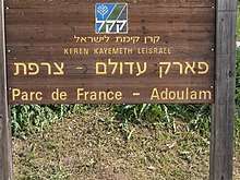
Adullam-France Park
| Adullam-France National Park | |
|---|---|
| פארק עדולם-צרפת | |
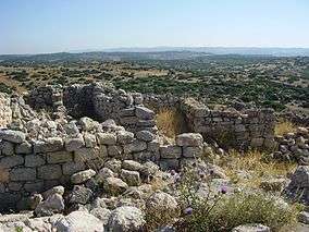 Lookout point at Hurvat Burgin | |
| Nearest city | Beit Shemesh |
| Coordinates | 31°39′08″N 34°57′22″E / 31.6522848°N 34.95609°ECoordinates: 31°39′08″N 34°57′22″E / 31.6522848°N 34.95609°E |
| Established | 2008 |
|
www | |
Adullam-France Park (Hebrew: פארק עדולם-צרפת ), also known as Parc dé France-Adoulam, is a sprawling park of 50,000 dunams (50 km2; 19 sq mi)(ca. 12,350 acres) in the Central District of Israel, located south of Beit Shemesh. The park, established in 2008 for public recreation, features two major hiking and biking trails, and four major archaeological sites from the Second Temple period. It stretches between Naḥal Ha-Elah (Highway 375), its northern-most boundary, to Naḥal Guvrin (Highway 35), its southern-most boundary. To its west lies the Beit Guvrin-Beit Shemesh highway, and to its east the “green line” – now territories under joint Israeli-Palestinian Arab control – which marks its limit.
Park features
The park's main attraction is its pristine, unspoiled beauty; gently rolling limestone hills clad in natural Mediterranean vegetation of underbrush (Sarcopoterium), oak trees (Quercus ssp.), mastic trees (Pistacia lentiscus), carobs (Ceratonia siliqua) and buckthorns (Rhamnus lycioides), including seasonal flowers endemic to the Land of Israel (anemones, cyclamens, almond blossoms and asphodels), all within the purlieu of Jerusalem. The hills are interspersed with low-lying riverine brooks. A section of the park has been planted with pine forests by early Jewish immigrants who settled in the Lachish region at the founding of the State. The park is replete with a picnic area, a lookout point and marked trails for hikers and bikers. The main bike trail, known as the Kanim Single Track, is made in the form of a loop and extends to a full 23-kilometers, traversing the park from west to east, and is suitable for experienced cyclists with a moderate level of technical ability. The other bike trail is known as the Illegal Resident's Trail. Within the confines of the park are four principal archaeological sites of historical importance: Adullam, Hurvat Itri, Ḥurvat Burjin (Burgin ruins)[1] and Ḥurvat Madras (Midras ruins), including two lesser known archaeological sites, Ḥurvat Kanim and Ḥurvat Rebbo,[2] and the Adullam Grove Nature Reserve. Remnants of other ancient settlements are known to dot the hilltop landscape. The park is run jointly by the Jewish National Fund (JNF – KKL), the Israel Nature and Parks Authority (INPA) and the Israel Antiquities Authority (IAA), and has a visitors' center with guided tours run by the Kfar Etzion Field School.[3] The park also caters to limited agricultural needs, such as in viniculture.
Etymology
The park takes its name from the biblical Adullam, now a ruin, but where King David once found refuge when he fled from Saul.
Main archaeological sites
- Ḥurvat Burgin, a site maintained by the JNF (KKL) in Israel, and where extensive archaeological excavations have been conducted. The site features ancient burial tombs, and a labyrinth of underground hiding places believed to have been associated with the Bar Kokhba era, a Roman villa, columbarium (dovecote), among other things. Until 1948, the Palestinian Arab village Khirbat Umm Burj was here.[4]
- Ḥurvat Itri, a partially restored town dating back to the Second Temple period, with a public building believed to be a synagogue, ritual baths, wine presses and caves.
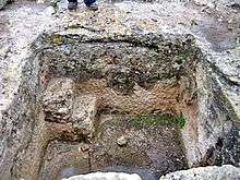
- Ḥurvat Midras (Madras), an archaeological site dating back to the Bar-Kokhba era, replete with no less than 56 caves and cisterns. The site also abounds with underground passages, an ancient burial site with sarcophagus, and a large columbarium. The site is located within the Adullam Grove Nature Reserve.
The main entrance to the park is accessible from regional hwy. 38, some 200 metres (660 ft) north of Moshav Givat Yeshayahu, about 10 kilometers (6.2 mi) south of Beit Shemesh. The park houses a visitors' center and an archaeological garden, held in offices run by the JNF (KKL) in conjunction with the Israel Antiquities Authority (IAA). The offices are open Mondays thru Thursdays, from 8:00 AM to 4:00 PM. In it are found artifacts and relics of Israel's distant past for the public's viewing, such as olive presses, ancient milestones, millstones and ossuaries. Additional places of interest in the region are the Elah Valley, Britannia Park and the Luzit Caves.
See also
External links
- Nature and Parks Authority Official Site
- Adullam Park Map
- The Jewish National Fund (KKL), Adullam-France Park: A Green Event Amid the Splendor of Nature
Gallery
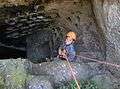 Child rappelling in an underground vault with columbarium (dovecote) at Park
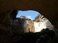 Entrance to large cave in the Adullam-France Park
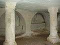 Cave of the columns, Hurvat Burgin
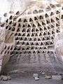 A columbarium in the Midras ruins
.jpg) Entrance to a tomb at the Midras ruins
Entrance to a tomb at the Midras ruins.jpg) View of Itri ruins
View of Itri ruins Exploring a tunnel in the Midras Ruin
 Columbarium at the Midras Ruin
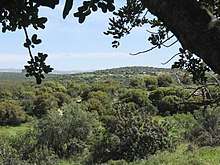 General landscape of the Adullam-France Park
 Ruins at the site of Khirbet Midras
 The entrance to the Adullam-France Park
 Niche in columbarium, at the Midras ruin
References
| Wikimedia Commons has media related to Adullam (region). |
- ↑ In the Topographical Map (Map # 9, Jerusalem Corridor) published by Israel's Nature Protection Society, the site is listed as Ḥurvat Burjin, but in Conder and Kitchener's Survey of Palestine Map (Map # 21), the site is listed as Umm Burj, a place that had already been a ruin in Conder's time (p. 380), but apparently resettled around the 20th century, and continuing to be until 1948.
- ↑ This ruin appears in Conder's and Kitchener's 1878 Survey of Palestine map (Sheet XXI) under the name Khurbet Rubba, and lies on a hilltop to the north of Hurvat Itri (Umm Suweid).
- ↑ Bakitzur – Mateh Yehuda Regional Council Weekly, Issue 388 (23 February 2017), p. 24 (Hebrew)
- ↑ Amir Ganor and Alon Klein (2011). "Horbat Burqin, Preliminary Report". Hadashot Arkheologiyot. 123.