Well of Harod
The Well of Harod or Spring of Harod (Hebrew: עין חרוד, Ein Harod) is a spring near the two kibbutzim called Ein Harod in the Jezreel Valley in Israel. In Arabic it is called ʿAyn Jalut (عين جالوت) meaning the Spring of Goliath.[1]
It is mentioned in the Book of Judges, chapter 7, where it is said that Gideon dismissed 22,000 potential warriors who were "fearful and afraid" and then chose 300 men to fight with him according to how they drank water from the Well of Harod.[2] Anglican bishop Charles Ellicott and Presbyterian theologian Albert Barnes both suggest that "Harod" means "trembling", "with an obvious allusion to the timidity of the people (chareed, Judges 7:3)".[3]
Yaqut al-Hamawi mentions Ain Jalut as "a small and pleasant town, lying between Nablus and Baisan, in the Filastin Province. The place was taken by the Rumi (Crusaders), and retaken by Saladin in 579 (1183 CE)."[4]
In the Battle of Ain Jalut in 1260, the Mamluks defeated the Mongol army of Hulagu Khan which was under the command of Kitbuqa.
According to the Palestine Exploration Fund's Survey of Western Palestine 1882, Victor Guérin stated that the rock from which the fountain springs has been artificially hollowed into a cavern.[5]
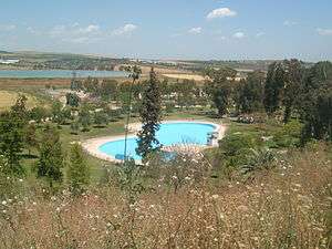
The well is now a national park called Ma'ayan Ḥarod.[6]
References
- ↑ Palmer, 1881, p. 157
- ↑ Judges 7: Gideon's Army of Three Hundred
- ↑ Ellicott's Commentary for Modern Readers on Judges 7 and Barnes' Notes on Judges 7, accessed 24 October 2016
- ↑ Quoted in le Strange, 1890, p. 386
- ↑ Conder and Kitchener, 1882, SWP II, p. 101
- ↑ Ma'ayan Harod National Park
Bibliography
- Conder, C.R.; Kitchener, H.H. (1882). The Survey of Western Palestine: Memoirs of the Topography, Orography, Hydrography, and Archaeology. 2. London: Committee of the Palestine Exploration Fund. (p. 116)
- Guérin, V. (1874). Description Géographique Historique et Archéologique de la Palestine (in French). 2: Samarie, pt. 1. Paris: L'Imprimerie Nationale. (pp. 308-310)
- Palmer, E.H. (1881). The Survey of Western Palestine: Arabic and English Name Lists Collected During the Survey by Lieutenants Conder and Kitchener, R. E. Transliterated and Explained by E.H. Palmer. Committee of the Palestine Exploration Fund.
- Strange, le, G. (1890). Palestine Under the Moslems: A Description of Syria and the Holy Land from A.D. 650 to 1500. Committee of the Palestine Exploration Fund.
External links
- Survey of Western Palestine (SWP), Map 9: IAA, Wikimedia commons