Givat Yeshayahu
| Givat Yeshayahu | |
|---|---|
 | |
 Givat Yeshayahu | |
| Coordinates: 31°40′10.91″N 34°57′2.16″E / 31.6696972°N 34.9506000°ECoordinates: 31°40′10.91″N 34°57′2.16″E / 31.6696972°N 34.9506000°E | |
| District | Jerusalem |
| Council | Mateh Yehuda |
| Affiliation | HaOved HaTzioni |
| Founded | 1958 |
| Founded by | Hungarian Jews |
| Population (2017)[1] | 846 |
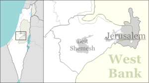
Givat Yeshayahu (Hebrew: גִּבְעַת יְשַׁעְיָהוּ, lit. Yeshayahu Hill) is a moshav in central Israel. Located in the Valley of Elah around ten kilometres south of Beit Shemesh, it falls under the jurisdiction of Mateh Yehuda Regional Council. In 2017 it had a population of 846.[1]
History
Givat Yeshayahu was established in 1958 by immigrants from Hungary, members of the Jewish youth movement HaNoar HaTzioni and was named after Yeshayahu Press, a prominent researcher. It was built on the land of the depopulated Palestinian village of 'Ajjur.[2]
In 2016, ancient Roman milestones from Highway 38 were moved to an archaeological park on the outskirts of Givat Yeshayahu.[3]
Givat Yeshayahu, surrounded by wineries and ancient wine presses, operates a factory that produces raisins although most raisins in Israel today are imported from California.[4]
References
- 1 2 "List of localities, in Alphabetical order" (PDF). Israel Central Bureau of Statistics. Retrieved August 26, 2018.
- ↑ Khalidi, Walid (1992). All That Remains: The Palestinian Villages Occupied and Depopulated by Israel in 1948. Washington D.C.: Institute for Palestine Studies. p. 207. ISBN 0-88728-224-5.
- ↑ Roman milestones, Givat Yeshayahu
- ↑ Israel's Last Raisin Factory, Haaretz