Rebbo
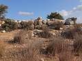
 Walled structures at Rebbo Ruin | |
 Location within Israel | |
| Coordinates | 31°39′51.23″N 34°58′47.833″E / 31.6642306°N 34.97995361°E |
|---|---|
| Grid position | 1481/1183 PAL |
Rebbo[1] or Horvat Rebbo (Hebrew: חורבת רִבּוֹא, lit. "Rebbo ruins"), alternative spellings: Robbo, Ribbo; in Arabic Khurbet Rubba (lit. "Rubba ruins"), is an ancient site in Israel, possibly mentioned by Eusebius in his Onomasticon.[2] The site, which is now a ruin, sits on a hill 414 metres (1,358 ft) above sea level, and is now part of the Adullam-France Park, maintained by the Jewish National Fund (KKL). It lies about 1.5 km. to the west of Aderet as the crow flies.
The site is quite extensive and contains tunnels believed to have been in use during the Bar Kokhba revolt. Tombs from the Second Temple period, agricultural features and cisterns (now covered with iron gratings) can be seen on the site. Many mastic trees (Pistacia lentiscus) and buckthorns (Rhamnus lycioides) cover the site.
In ancient sources
Eusebius (4th century) writes that in his day it was a village, called in Greek: Ῥοββώ and situated "in the territory of Eleutheropolis (Beit Gubrin) to the east."[3]
Archaeological surveys
Conder and Kitchener (1878)
The ruin appears in Conder and Kitchener's 1878 Survey of Palestine map under the name Khurbet Rubba. They noted under "Rabba" that it was a "city of Judah, mentioned with Kirjath Jearim (Joshua XV. 60). In the Onomasticon a place called Rebbo is mentioned as east of Eleutheropolis, which might be the same. A good-sized ruin named Rubba is found in the low hills south of the valley of Elah, north-east of Beit Jibrin, which would be in a suitable position for the early Christian site."[4] They found there "Caves, cisterns, and heaps of stones, ruined walls, bases of pillars and shafts much worn, two lintel stones with crosses, both measuring about 7 feet by 2 1/2 feet."[5]
A. Saarisalo (pre-1931)
The site was surveyed by Finnish archaeologist A. Saarisalo in the early 20th century, who concluded that the village was inhabited as late as the Byzantine and early Arab periods.[6]
Gallery
 Wall at Khirbat Rubba (Rebbo)
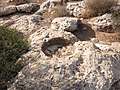
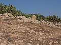 Stone structures at Rebbo Ruin
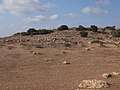 Dell on lower east side of Rebbo Ruin
 Ruins at Khirbat Rubba
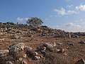 General view of Rebbo Ruin
 Moshav Aderet seen in distance from Horbat Rebbo
.jpg) Broken mouth of well at Rebbo Ruin
Broken mouth of well at Rebbo Ruin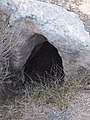 Entrance to cave at ruin
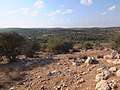 Looking towards the south from Horbat Rebbo
 Remnant of old wall at Khirbat Rubba
.jpg) Hewn stones lining a pit at Rebbo
Hewn stones lining a pit at Rebbo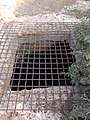 Grating covering pit at Rebbo
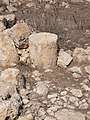 Stone column at Rebbo
- Wall at Khirbat Rubba
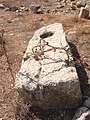 Large slab of stone at Rebbo
 General view looking south of Rebbo Ruin
- Lone tree on top of ruins
 Wine press carved in rock at Rebbo ruin
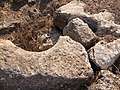 Broken mouth of well, now sealed
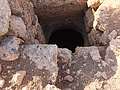 Gaping hole of pit (cavern) at Rebbo
References
- ↑ Palmer, 1881, p. 401
- ↑ Elitzur, 2004, p. 356
- ↑ Notley & Safrai, 2005, pp. 136–137 (§778)
- ↑ Conder & Kitchener, 1883, SWP III, p. 314
- ↑ Conder & Kitchener, 1883, SWP III, p. 360
- ↑ Aapeli Saarisolo, "Topographical Researches in the Shephelah", in: The Journal of the Palestine Oriental Society, vol. XI, Jerusalem 1931, p. 16
Bibliography
- Conder, C.R.; Kitchener, H.H. (1883). The Survey of Western Palestine: Memoirs of the Topography, Orography, Hydrography, and Archaeology. 3. London: Committee of the Palestine Exploration Fund.
- Elitzur, Yoel (2004). Ancient Place Names in the Holy Land - Preservation and History. Hebrew University, Magnes Press. ISBN 1-57506-071-X.
- Notley, R.S.; Safrai, Z. (2005). Eusebius, Onomasticon - The Place Names of Divine Scripture. Leiden: Brill. ISBN 0-391-04217-3.
- Palmer, E.H. (1881). The Survey of Western Palestine: Arabic and English Name Lists Collected During the Survey by Lieutenants Conder and Kitchener, R. E. Transliterated and Explained by E.H. Palmer. Committee of the Palestine Exploration Fund.
External links
- Survey of Western Palestine, Map 21: IAA, Wikimedia commons