16 Avenue N
Route map:
| |
|---|---|
|
Highway 1 Trans-Canada Highway | |
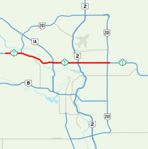 16 Avenue N highlighted in red | |
| Route information | |
| Maintained by City of Calgary | |
| Length | 26.5 km[1] (16.5 mi) |
| Major junctions | |
| West end |
East of Old Banff Coach Road (Calgary city limit) |
| |
| East end |
East of Stoney Trail (Calgary city limit) |
| Location | |
| Major cities | Calgary |
| Highway system | |
| Provincial highways in Alberta | |

| Neighbourhoods |
|---|
List...
|
16 Avenue N is a major road in Calgary, Alberta, Canada that forms a 26.5-kilometre (16.5 mi) segment of Highway 1 (Trans-Canada Highway) and connects Calgary to Banff and Medicine Hat. It is a four to six-lane principal arterial expressway at its extremities, but is an urban arterial road between the Bow River and Bowness Road, and also between Crowchild Trail and Deerfoot Trail. Due to Calgary's quadrant system, it is known as 16 Avenue NW west of Centre Street and 16 Avenue NE to the east.[2]
Route description
16 Avenue NW
The Trans-Canada Highway in Alberta originates at the British Columbia border, where it proceeds east through Banff National Park to Calgary and becomes 16 Avenue NW. It first intersects Valley Ridge Boulevard / Crestmont Boulevard before a major interchange at Stoney Trail (Highway 201), a partial ring road the borders Calgary to the north and east. Signage recommending that traffic en route to the International Airport, Edmonton, and Medicine Hat use Stoney Trail as a bypass.[3] It continues past Canada Olympic Park to an intersection at Bowfort Road, where construction of a single point urban interchange is expected to be completed in the summer of 2017.[4] It passes along the southern boundary of the former town of Bowness and begins to descend into the Bow River valley where it intersects Sarcee Trail, an expressway providing a bypass option to Highway 2 south. 16 Avenue NW begins to transition to a four lane, arterial road and crosses the Bow River. Between the city limits and Sarcee Trail, 16 Avenue NW separates the northwest and southwest quadrants of Calgary.[5]
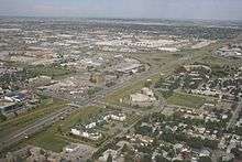
After crossing the Bow River, 16 Avenue NW passes through the former village of Montgomery after which it becomes a short expressway that crosses Bowness Road (signed as Memorial Drive for eastbound traffic), Shaganappi Trail, and exits the Bow River valley. It passes the Alberta Children's Hospital and Foothills Medical Centre before crossing University Drive, which provides access to the University of Calgary, McMahon Stadium, and access to southbound Crowchild Trail. After crossing Crowchild Trail, it becomes a six lane arterial road with numerous signalized intersections and extensive commercial development. It passes Motel Village, a cluster of motels which were constructed due to its proximity to the Trans-Canada Highway, which is accessible via a signalized service road and Banff Trail, which also doubles as the access road northbound Crowchild Trail. It passes by North Hill Centre (Calgary's first shopping mall),[6] 14 Street NW, and Southern Alberta Institute of Technology (SAIT) continuing east and intersects Centre Street, leaving the northwest quadrant.[5]
16 Avenue NE
At Centre Street, 16 Avenue NE enters the northeast quadrant and continues east, and intersects Edmonton Trail before descending the Nose Creek valley and intersects Deerfoot Trail (Highway 2) through a split-diamond interchange before it leaves the valley and intersects 19 Street NE. East of 19 Street NE, it becomes a short freeway, beginning with a cloverleaf interchange at Barlow Trail; the area is formerly known as Crossroads since it used to be the former alignment of Highway 2 - while neighbourhood has since been renamed to Mayland Heights, some of the areas businesses still utilized the Crossroads name. 16 Avenue continues east with interchanges at 36 Street NE and 52 Street NE before intersecting 68 Street NE. It again intersects Stoney Trail, where westbound signage recommends that traffic en route to Banff, Edmonton, and Lethbridge use Stoney Trail as a bypass,[7] before leaving Calgary and heading east towards Chestermere, Medicine Hat, and the Saskatchewan border.
History
Sixteenth Avenue North was part of the village of Crescent Heights until annexed by The City of Calgary in the early 1900s. An electric trolley ran down the artery connecting the area with downtown from 1911 to the mid-1900s. The electric trolley was slowly phased out and replaced with buses. In fact, Calgary’s first park and ride was on the Tuxedo bus loop in 1956 and one of three trial express buses started on October 21, 1957—the Yellow Pennant Express from Capitol Hill.[8]
In the 1950s, Highway 1 was rerouted from 17 Avenue SE and a series of streets through downtown Calgary to follow 16 Avenue N as part of the Trans-Canada Highway construction; however shortly afterwards the City of Calgary began to study alternate routes in an effort to relieve congestion.[9] In 1970, the City of Calgary a proposed freeway that would run north of 16 Avenue N between 23 and 24 Avenue N, but the plans were cancelled.[10][11] In the following years, different bypass options were studied in conjunction with plans for a Calgary ring road, including the possibility of the Trans-Canada Highway following Sarcee Trail (including an extension through the Tsuu T'ina Nation), Highway 22X, and Highway 901 before rejoining Highway 1 near Gleichen that was proposed by Alberta Transportation in 1989;[9] this plan was rejected as Calgary is considered a major destination city and was opposed by business owners along the 16 Avenue N.[12] On November 2, 2009, the northeast section of Stoney Trail was opened, providing a 41 km (25 mi) bypass option for the Trans-Canada Highway around north Calgary.[13]
The inner city section of 16 Avenue N was a four lane, undivided street. From 2002–2010, the City of Calgary widened it to a six lane urban boulevard between removing buildings along south side of 16 Avenue N between 10 Street NW and 6 Street NE.[14]
Future
The City of Calgary considers 16 Avenue N as part of the skeletal road network,[15] however the sections through Montgomery (between the Bow River and Bowness Road)[16] and between Banff Trail and Deerfoot Trail as Main Streets - streets that would be mixed use residential and commercial corridors.[17] The City of Calgary have long-term plans in converting 16 Avenue N to a freeway in the outlying areas, which includes converting the Deerfoot Trail interchange into a three-level diamond interchange, and interchanges at 19 Street NE[18] and 68 Street NE. With the projected completion of the Bowfort Road interchange in summer 2017, 16 Avenue NW will be a freeway west of Sarcee Trail to its western terminus.
Major intersections
From west to east.[2] The entire route is in Calgary.
| km[1] | mi | Exit | Destinations | Notes | |
|---|---|---|---|---|---|
| 0.0 | 0.0 | Continuation west of Calgary | |||
| 1.9 | 1.2 | Valley Ridge Boulevard / Crestmont Boulevard | Partial cloverleaf interchange | ||
| 3.1 | 1.9 | 177 | Semi-directional T interchange (Hwy 201 Exit 36) | ||
| 4.7 | 2.9 | Canada Olympic Drive / Bowfort Road – Canada Olympic Park | Single-point urban interchange[4] | ||
| 6.2 | 3.9 | Partial cloverleaf interchange | |||
| 6.5 | 4.0 | 29 Avenue NW | Westbound right-in/right-out | ||
| 7.1 | 4.4 | Crosses the Bow River | |||
| 7.9 | 4.9 | 49 Street NW | At grade | ||
| 8.1 | 5.0 | Home Road | At grade; traffic signals | ||
| 8.3 | 5.2 | 46 Street NW | At grade | ||
| 9.4 | 5.8 | Memorial Drive / Bowness Road | Partial cloverleaf interchange; eastbound access to Memorial Drive and Shaganappi Trail; westbound access to Bowness Road | ||
| 9.6 | 6.0 | Shaganappi Trail | Half-diamond interchange; westbound access to Memorial Drive | ||
| 10.0 | 6.2 | Partial cloverleaf interchange | |||
| 11.0 | 6.8 | At grade; traffic signals | |||
| 11.5 | 7.1 | University Drive to Crowchild Trail south – McMahon Stadium, University of Calgary | Cloverleaf interchange | ||
| 12.0 | 7.5 | Access road | At grade; traffic signals | ||
| 12.2 | 7.6 | At grade; traffic signals | |||
| 12.6 | 7.8 | At grade; traffic signals | |||
| 12.9 | 8.0 | 17 Street NW – North Hill Centre | At grade; traffic signals | ||
| 13.2 | 8.2 | Access road – North Hill Centre | At grade; traffic signals | ||
| 13.4 | 8.3 | 14 Street NW – SAIT, ACAD, Jubilee Auditorium, City Centre | Diamond interchange; traffic signals | ||
| 13.7 | 8.5 | 12 Street NW – SAIT | At grade; traffic signals | ||
| 14.1 | 8.8 | 10 Street NW | At grade; traffic signals | ||
| 14.3 | 8.9 | 8 Street NW | At grade; traffic signals | ||
| 14.7 | 9.1 | 6 Street NW | At grade; traffic signals | ||
| 15.0 | 9.3 | 4 Street NW | At grade; traffic signals | ||
| 15.3 | 9.5 | 2 Street NW | At grade; traffic signals | ||
| 15.7 | 9.8 | Centre Street N – City Centre | At grade; traffic signals | ||
| 15.8 | 9.8 | 1 Street NE | At grade; traffic signals | ||
| 16.1 | 10.0 | Edmonton Trail | At grade; traffic signals | ||
| 16.5 | 10.3 | 5 Street NE | At grade; traffic signals | ||
| 16.6 | 10.3 | 6 Street NE | At grade; traffic signals | ||
| 17.1 | 10.6 | Moncton Road / Russet Road | At grade; traffic signals | ||
| 18.1 | 11.2 | Split diamond interchange (Hwy 2 Exit 225); traffic signals | |||
| 19.1 | 11.9 | 19 Street NE | At grade; traffic signals | ||
| 19.9 | 12.4 | Barlow Trail | Cloverleaf interchange | ||
| 21.3 | 13.2 | Partial cloverleaf interchange; eastbound access to Sunridge Way | |||
| 22.9 | 14.2 | 52 Street NE | Partial cloverleaf interchange. | ||
| 24.6 | 15.3 | 68 Street NE | At grade; traffic signals; no southbound access from Stoney Trail | ||
| 25.6 | 15.9 | Cloverstack interchange (Hwy 201 Exit 78) | |||
| 26.5 | 16.5 | Continuation east of Calgary | |||
1.000 mi = 1.609 km; 1.000 km = 0.621 mi
| |||||
See also
References
- 1 2 Google (December 9, 2016). "16 Avenue N in Calgary, AB" (Map). Google Maps. Google. Retrieved December 9, 2016.
- 1 2 Sherlock Publishing (2014). Sherlock's Map of Calgary (Map) (16th ed.). Langdon, AB: Sherlock Publishing. pp. 15–17, 25–30. ISBN 1-895229-80-4.
- ↑ Google (June 2016). "Stoney Trail NW sign". Google Street View. Google. Retrieved December 9, 2016.
- 1 2 Stantec (November 2014). "Bowfort Road N.W. / Trans Canada Highway Interchange Project" (PDF). City of Calgary. Retrieved December 9, 2016.
- 1 2 "Calgary City Quadrants (NE, SE, SW, NW)". www.calgarymapped.com. Retrieved December 9, 2016.
- ↑ "Centre History". North Hill Centre. Retrieved December 12, 2016.
- ↑ Google (August 2015). "Stoney Trail NE sign". Google Street View. Google. Retrieved December 9, 2016.
- ↑ Linn, Brad (June 14, 2010). "The new face of 16 Avenue North". Calgary City News Blog. City of Calgary. Retrieved December 12, 2016.
- 1 2 Salus, Jesse (January 24, 2013). "The Trans-Canada Highway and the Ring Road". Calgary Ring Road. Retrieved December 12, 2016.
- ↑ Trans Canada Highway: Functional Planning Study. City of Calgary. June 1970.
- ↑ "Alberta Roads". Calgary Historical Roadway Plans. Retrieved December 12, 2016.
- ↑ Beaty, Bob (March 8, 1989). "Plan to move highway irks tourism operators". Calgary Herald.
- ↑ "Northeast Stoney Trail". Alberta Transportation. Government of Alberta. October 3, 2007.
- ↑ Linn, Brad (December 10, 2009). "16 Avenue North Urban Corridor: Wide Open". Calgary City News Blog. City of Calgary. Retrieved December 12, 2016.
- ↑ "Calgary Transportation Plan" (PDF). City of Calgary. September 2009. p. 95. Retrieved December 12, 2016.
- ↑ "Key findings by Main Street: 16 Avenue NW (Montgomery)" (PDF). YYC's Main Streets. City of Calgary. p. 4. Retrieved December 12, 2016.
- ↑ "16 Avenue North Urban Corridor Area Redevelopment Plan" (PDF). City of Calgary. May 2016. Retrieved December 12, 2016.
- ↑ "Recommended Option" (Map). 16 Avenue N.E. Functional Planning Study: Deerfoot Trail to Barlow Trail. City of Calgary. November 2014. Retrieved December 12, 2016.
External links
- Trans Canada Highway Freeway Plan (1970)
- Trans Canada Highway / Bowfort Road N.W. Interchange Project and related roadworks
- 16 Avenue North Corridor Area Redevelopment Plan Review
- Main Streets - Planning the future of Calgary's thriving main streets
- 16 Avenue N.E. Functional Planning Study: Deerfoot Trail to Barlow Trail