Ōfunato, Iwate
| Ōfunato 大船渡市 | |||
|---|---|---|---|
| City | |||
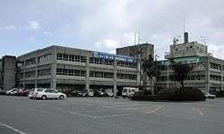 Ōfunato City Hall | |||
| |||
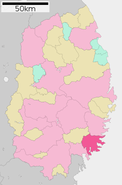 Location of Ōfunato in Iwate Prefecture | |||
 Ōfunato | |||
| Coordinates: 39°4′4.8″N 141°43′30.8″E / 39.068000°N 141.725222°ECoordinates: 39°4′4.8″N 141°43′30.8″E / 39.068000°N 141.725222°E | |||
| Country | Japan | ||
| Region | Tōhoku | ||
| Prefecture | Iwate | ||
| Area | |||
| • Total | 322.50 km2 (124.52 sq mi) | ||
| Population (April 1, 2017) | |||
| • Total | 37,562 | ||
| • Density | 116.5/km2 (302/sq mi) | ||
| Time zone | UTC+9 (Japan Standard Time) | ||
| City symbols | |||
| - Tree | Pine | ||
| - Flower | Camellia | ||
| - Bird | Black-tailed gull | ||
| Phone number | 0192-27-3111 | ||
| Address | 15, Sakarichō Aza Utsunosawa, Ōfunato-shi, Iwate-ken 022-8501 | ||
| Website | http://www.city.ofunato.iwate.jp | ||


Ōfunato (大船渡市 Ōfunato-shi) is a city located in Iwate Prefecture, Japan. As of 1 April 2017, the city had an estimated population of 37,562, and a population density of 116.5 persons per km2 in 15,017 households.[1] The total area of the city is 322.50 square kilometres (124.52 sq mi).[2]
Geography
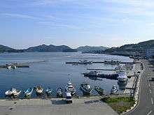
Ōfunato is located in southeastern Iwate Prefecture, with the Pacific Ocean to the east. Outside its bay, the warm and cold ocean currents meet, which allow a commercial fishing industry to flourish. The city has been attempting to establish itself as a major shipping port and receives regular visits by international freight ships. Kaminari-iwa on the city's Goishi coastline has been designated one of the 100 Soundscapes of Japan by the Ministry of the Environment.[3] Much of the city is within the borders of the Sanriku Fukkō National Park.
Neighbouring municipalities
- Iwate Prefecture
Demographics
Per Japanese census data,[4] the population of Ōfunato has declined over the past 40 years.
| Census Year | Population |
|---|---|
| 1970 | 48,816 |
| 1980 | 50,132 |
| 1990 | 47,219 |
| 2000 | 45,160 |
| 2010 | 40,737 |
Climate
Ōfunato has a humid subtropical climate (Köppen climate classification Cfa) bordering on a humid continental climate (Köppen climate classification Dfa) with warm summers and cold winters. The average annual temperature in Ōfunato is 8.4 °C. The average annual rainfall is 1472 mm with September as the wettest month and January as the driest month. The temperatures are highest on average in August, at around 21.0 °C, and lowest in January, at around -2.9 °C.[5]
| Climate data for Ōfunato, Iwate | |||||||||||||
|---|---|---|---|---|---|---|---|---|---|---|---|---|---|
| Month | Jan | Feb | Mar | Apr | May | Jun | Jul | Aug | Sep | Oct | Nov | Dec | Year |
| Average high °C (°F) | 4.1 (39.4) |
4.3 (39.7) |
7.5 (45.5) |
13.5 (56.3) |
18.5 (65.3) |
21.3 (70.3) |
24.5 (76.1) |
26.9 (80.4) |
23.0 (73.4) |
18.2 (64.8) |
12.7 (54.9) |
7.1 (44.8) |
15.1 (59.2) |
| Daily mean °C (°F) | 0.4 (32.7) |
0.5 (32.9) |
3.2 (37.8) |
8.8 (47.8) |
13.6 (56.5) |
17.3 (63.1) |
20.8 (69.4) |
23.0 (73.4) |
19.0 (66.2) |
13.4 (56.1) |
8.1 (46.6) |
3.2 (37.8) |
10.9 (51.7) |
| Average low °C (°F) | −3.2 (26.2) |
−3.3 (26.1) |
−1.0 (30.2) |
3.9 (39) |
8.8 (47.8) |
13.6 (56.5) |
17.7 (63.9) |
19.8 (67.6) |
15.3 (59.5) |
8.7 (47.7) |
3.4 (38.1) |
−0.7 (30.7) |
6.9 (44.4) |
| Average precipitation mm (inches) | 45.7 (1.799) |
61.4 (2.417) |
86.6 (3.409) |
141.6 (5.575) |
149.7 (5.894) |
154.0 (6.063) |
165.3 (6.508) |
197.6 (7.78) |
194.5 (7.657) |
138.7 (5.461) |
99.6 (3.921) |
44.3 (1.744) |
1,479 (58.228) |
| Average snowfall cm (inches) | 12 (4.7) |
19 (7.5) |
10 (3.9) |
0 (0) |
0 (0) |
0 (0) |
0 (0) |
0 (0) |
0 (0) |
0 (0) |
1 (0.4) |
7 (2.8) |
49 (19.3) |
| Average relative humidity (%) | 62 | 63 | 63 | 67 | 72 | 80 | 84 | 82 | 80 | 74 | 68 | 64 | 72 |
| Mean monthly sunshine hours | 153.6 | 146.1 | 176.1 | 177.2 | 208.4 | 163.7 | 151.4 | 165.5 | 124.9 | 154.1 | 138.9 | 140.1 | 1,900 |
| Source: NOAA (1961-1990)[6] | |||||||||||||
History
The area of present-day Ōfunato was part of ancient Mutsu Province, and has been settled since at least the Jōmon period, and numerous shell middens around Ōfunato Bay have been excavated by archaeologists. During the Sengoku period, the area was dominated by various samurai clans before coming under the control of the Date clan during the Edo period, who ruled Sendai Domain under the Tokugawa shogunate.
The modern village of Ōfunato was created within Kessen District, Iwate on April 1, 1889. The 1896 Sanriku earthquake caused a 25-meter tsunami which killed 27,000 people in the area. Ōfunato was elevated to town status on April 1, 1932. The 1933 Sanriku earthquake had a magnitude of 8.4 and caused a 28-meter tsunami which killed 1522 people.
The neighboring town of Sakari and the villages of Akasaki, Takkon, Massaki, Ikawa and Hikoroichi merged with Ōfunato on April 1, 1952, forming the city of Ōfunato. The city became internationally famous when it was hit by a tsunami caused by the Valdivia earthquake in Chile May 22, 1960. On November 15, 2001, the town of Sanriku (from Kesen District) was merged into Ōfunato.
2011 Tōhoku earthquake and tsunami
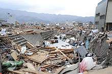
Ōfunato hit the headlines again when it was heavily damaged in the 2011 Tōhoku earthquake and tsunami.[7] The wave was estimated to have reached 23.6 meters in height.[8] Funneled in by the narrow bay, the tsunami continued inland for 3 kilometres.[9] The town's theatre was one of very few buildings left standing (and remarkably, was undamaged) and gave shelter to about 250 survivors.[10][11] Provisional counts listed 3,498 houses out of 15,138 houses in the town destroyed by the tsunami and 305 lives were confirmed lost.[12][13] At least six of the town's 58 designated evacuation sites were inundated by the tsunami.[14] Ofunato was featured in the British documentary "Japan's Tsunami Caught on Camera" which was broadcast on Channel 4 in the United Kingdom.
Government
Ōfunato has a mayor-council form of government with a directly elected mayor and a unicameral city legislature of 25 members.
Economy
The local economy is largely based on commercial fishing, with cement production and wood processing as secondary industries.
Education
- Kitasato University – Sanriku campus
- Ōfunato has 11 public elementary schools and eight public middle schools operated by the city government, and three public high schools operated by the Iwate Prefectural Board of Education..
Transportation
Railway
- Sanriku Railway Company – Minami Rias Line
- Sakari - Rikuzen-Akasaki - Ryōri - Koishihama - Horei - Sanriku - Yoshihama
- JR East – Ōfunato Line (services suspended indefinitely and replaced by a BRT)
- Hosoura - Shimofunato - Ōfunato - Sakari
Highway
Port
- Port of Ōfunato
Local attractions
- Goishi Coast, nationally designated Place of Scenic Beauty and Natural Monument[15]
International relations

Noted people from Ōfunato
- Yoshinobu Fujiwara, politician
- Nanae Sasaki, marathon runner
- Tochinohana Hitoshi, sumo wrestler
References
- ↑ official city home page (in Japanese)
- ↑ "詳細データ 岩手県紫波町". 市町村の姿 グラフと統計でみる農林水産業 (in Japanese). Ministry of Agriculture, Forestry and Fisheries. 2016. Retrieved 13 April 2017.
- ↑ "100 Soundscapes of Japan". Ministry of the Environment. Retrieved 8 December 2015.
- ↑ Ōfunato population statistics
- ↑ Ōfunato climate data
- ↑ "Ofunato Climate Normals 1961-1990". National Oceanic and Atmospheric Administration. Retrieved 29 December 2012.
- ↑ Ofunato devastated by tsunami BBC report, 12 March 2011
- ↑ "23.6-meter-high tsunami triggered by March 11 quake: survey" Kyodo News, 23 March 2011
- ↑ A thousand bodies a day will be recovered every day now The Age, 22 March 2011
- ↑ Synopsis of a Channel 4 TV news bulletin on 15 March 2011
- ↑ Tritten, Travis, J., and T. D. Flack, "U.S. rescue teams find devastation in northern city of Ofunato", Stars and Stripes, 15 March 2011, retrieved 16 March 2011.
- ↑ NOAA tsunami data table
- ↑ Gilhooly, Rob, "Survivors strive to start picking up the pieces", Japan Times, 27 March 2011, p. 7.
- ↑ Kyodo News, "Tsunami hit more than 100 designated evacuation sites Archived 18 April 2011 at WebCite", Japan Times, 14 April 2011, p. 1.
- ↑ "碁石海岸". Agency for Cultural Affairs. Retrieved 10 February 2012.
- ↑ "International Exchange". List of Affiliation Partners within Prefectures. Council of Local Authorities for International Relations (CLAIR). Retrieved 21 November 2015.
External links
![]()
- Official Website (in Japanese)