Çaykara
| Çaykara | |
|---|---|
 Çaykara | |
| Coordinates: 40°44′51″N 40°14′31″E / 40.74750°N 40.24194°ECoordinates: 40°44′51″N 40°14′31″E / 40.74750°N 40.24194°E | |
| Country | Turkey |
| Province | Trabzon |
| Government | |
| • Mayor | Hanefi Tok (AKP) |
| Area[1] | |
| • District | 573.14 km2 (221.29 sq mi) |
| Population (2012)[2] | |
| • Urban | 2,000 |
| • District | 13,220 |
| • District density | 23/km2 (60/sq mi) |
| Climate | Cfa |
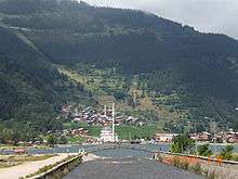
Çaykara (Romeyika: Kadahor) is a town and district of Trabzon Province in the Black Sea region of Turkey. As of 2014, the District Mayor of Çaykara is Hanefi Tok (AKP). Çaykara village lies in a V-shaped valley along the Solaklı River in the Pontic Mountains, at an elevation of around 300 metres. Çaykara district lies to the south of Dernekpazarı (Kondu) and forms the upper part of the Of-valley system ('Solaklı Vadisi' in Turkish), with peaks reaching to over 3300 meters. The western half of İkizdere district - which lies just east of Çaykara and is now part of Rize province - was historically also part of the same administrative and cultural region. Large swathes of the district are made up of old-growth temperate broadleaf and mixed forest, gradually making way for alpine tundra at higher altitudes.
Etymology
The district takes its name from the Çaykara stream, which forms through the conjunction of the Solaklı and Yeşilalan brooks. The historic name of Çaykara is Kadahor (from Kato Choriou "lower village" in Pontic Greek).[3] As is typical in transhumance communities in the Pontic Mountains and the Caucasus, Kadahor was settled with a number of subordinate upland villages for different seasons, which explains its name.
History
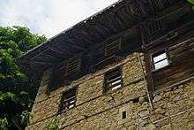
There is no evidence of permanent settlement in the valley before the middle ages, when it was part of the Byzantine Empire. However, this may be due to the frequent landslides that occur there, and the limited archeological research which has been conducted. A few place names hint at a possible Chaldian presence in the valley before it was Hellenized, such as the Haldizen (Χάλντιζεν) stream in the southeast of the district and the village 'Halt' (Χάλτ, or Söğütlü in Turkish), downstream in Of-district. It is assumed that Kadahor was one of the original settlements in the area, which may explain its name and function as the central market-town of the upper valley.
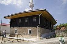
According to local oral histories, the valley functioned as an alternative trading route during the late medieval period connecting Trabzon - through the coastal town of Of - to Persia and beyond. At that time the valley was part of the Empire of Trebizond. On a hill overlooking Çaykara town, just west of the village Taşören (Zeleka), lies a ruined fortress which according to locals was constructed by Genoese traders. The Genoese also held the fortress town of Bayburt - south of Çaykara - which could be reached by the mountain pass near Sakarsu (modern Şekersu). The local dialect of Pontic Greek started to diverge from the Greek spoken in urban centers somewhere between the 12th and the 15th century. Çaykara entered Ottoman rule in 1461, following the Ottoman conquest of the Empire of Trebizond by Sultan Mehmed II. According to Greek historiographers the valleys attracted residents of coastal cities who sought refuge from Ottoman taxation. While the population of the valley at that time was mostly made up of Greek-speaking Christians, the locals did have interactions with nomadic Turkish tribes on the summer pastures.
According to the Ottoman tax books (tahrir defterleri) of 1486, there were 1277 people living in the historic villages that were located within the present-day Çaykara district (namely the villages of Ğorğoras (in Greek: Γοργορά), Holayisa, Paçan and Zeno (in Greek: Ξένος), where there were 235 houses (1 of them inhabited by Muslims, 234 of them by Christians.)[4] During the Ottoman period the valley also housed a small number of Armenians, who had settled there in the villages Fotinos and Harhes after they had been attacked and chased-off from neighboring valleys by a clan leader called İslamoğlu Bey.
According to the Ottoman tax books (tahrir defterleri) of 1681, the inhabitants of the villages of Ğorğoras, Holayisa, Paçan, Zeno, Yente, Haldizen, İpsil (in Greek: Υψηλή), Okene, Sero (Siros), Kadahor, Hopşera, Sarahos (in Greek: Σαχάρω), Fotinos (in Greek: Φωτεινός) and Zeleka had been fully converted to Islam.[4] In 1681, there were 2100 people living in 380 houses, all of them Muslims.[4] The villages in the valley had a well developed educational system; In the late Ottoman period the uplands of Çaykara housed dozens of seminaries, attracting students from across Anatolia. As a result the region had one of the highest literacy rates in the empire, and many of the inhabitants of the valley registered surnames in the 19th century - well before other Muslim groups in Anatolia. This history of literacy is reflected in the many scientists, politicians, musicians, directors, etc. that came from the sparsely populated villages in the district. At times the valley also attracted small groups of settlers or refugees from other parts of the empire, such as Arabs from Maraş and Circassians from the Caucasus.
In 1915, during the Caucasus Campaign of World War I, Ottoman forces and local guerrillas fought the invading Russian army at the Sultan Murat Plateau (Turkish: Sultan Murat Yaylası 40°40′12″N 40°10′13″E / 40.67000°N 40.17028°E), a high plateau 25 km (16 mi) southwest of Çaykara's town center. A monumental cemetery for the fallen Ottoman soldiers, named Şehitler Tepesi (Hill of Martyrs) is located there. The Russian army constructed a new road through the valley, connecting it to the Anatolian plateau south of the Pontic Mountains. The road was meant to function as an alternative supply route for the Russian forces in eastern Anatolia, as they were unable to hold the Zigana Pass south of Trabzon. Part of the road is still in use as the D915, which is recognized as one of the most dangerous roads in the world [5] due to its many hairpins without guard rails.
Because of their Islamic identity, the inhabitants of Kadahor/Çaykara were not deported during the population exchange between Greece and Turkey in 1923. A few dozen families from the valley that had retained their Christian beliefs chose to resettle in Macedonia, Greece, in the village of Nea Trapezounta (New Trabzon). Many families across the valley retain some contact with relatives in Greece.
Until 1925, Çaykara was a village bound to the Of district within Trabzon Province. In 1925, it became a bucak (subdistrict), and on 1 June 1947 it became an ilçe (district) of Trabzon Province. In the 1960s all of the villages in the district were officially renamed, but except for Çaykara and Uzungöl - which are the places where the community interacts with the state - these new Turkish names have not caught on. Local toponyms of Greek, Chaldian and Armenian origin such as the names of seasonal settlements, streams, hills and mountains remain in use.
The mother tongue of most inhabitants of the district is the Of-dialect of Pontic Greek, colloquially called Romeyka (i.e. 'language of the Romans'), which has been described as the living language closest to Ancient Greek[6]. Due to the community's isolation the dialect retained many archaisms. There are about two dozen Grecophone villages in the district, making it the largest concentration of Greek speakers in the Turkish Republic. While locals generally don't like being addressed as Greek, they are proud of their linguistic heritage, which they use to communicate with Greek-speaking tourists [7]. Inhabitants from Of and Çaykara also settled villages in neighboring Sürmene district and in Tonya, a little further to the west. Thus there are also some pockets of Çaykara/Of-dialect Greek speaking villages in these other parts of Trabzon province. That the Of-dialect of Pontic Greek remains so virulent in this sparsely populated area is partly due to the fact that local imams educated and preached in this language until the second part of the 20th century.
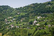
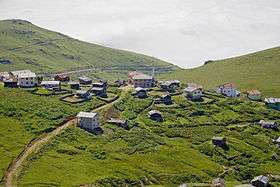
Many of the permanent residents of the district still live a life of transhumance, migrating with their cattle between two or three different settlements belonging to the same village; An agricultural settlement near the bottom of the valley, a logging village halfway up the mountain, and a hamlet on the summer grazing land above the tree line. On Tuesdays villagers head down to the local market at Çaykara town. In recent years the valley has become a major tourist attraction. During the summer months Lake Uzungöl attracts thousands of tourists on a daily basis.
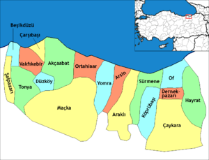
Villages

Within Çaykara district there are about 30 villages which are more or less permanently settled. These villages are listed north to south, with their Turkish and Greek names. In most cases these villages also have (or share) a distinct logging settlement and a hamlet on the summer pasture. These smaller seasonally occupied places are not listed here.
- Akdoğan - Yukarı Hopşera / Χοψερά
- Soğanlı - Aşağı Hopşera / Κάτω Χοψερά
- Kabataş - Fotinos / Φωτεινός
- Baltacılı/Yeşilalan - Xolaisa / Χολάισσα
- Çaykara - Kadahor, Kato Horiou, Katohoriou, Kato Choriou, Katokhor, Katohori / Κατωχωρίου
- Taşören - Zeleka / Ζέλεκα
- Kayran - Limli / Λιμνή
- Fındıklıdere - Lemetos
- Eğridere - Ğorğoras / Γοργοράς, Γρηγοράς
- Işıklı - Huşo
- Sur - Şiro / Σύρος, Σούρ'
- Maraşlı - (Nefsi) Paçan, Patsan / (Νεφσί) Πατσάν
- Koldere - Vahtanç / Βαχτάνος
- Şahinkaya - Feğmonos
- Ataköy - Şinek / Σινέκ
- Yukarıkumlu - Aso Mimiloz / Άνω Μίμιλος
- Aşağıkumlu - Kato Mimiloz / Κάτω Μίμιλος
- Çambaşı - Anaşo, Anatho / Άνωθο
- Taşlıgedik - Mezrai Paçan, Mezire-i Patsan / Μεζιρέ Πατσάν
- Çamlıbel - Harheş / Άνω Σινέκ
- Taşkıran - Çoroş / Τσορόσ', Χορχός ή Τσόρος
- Köşeli - Klisura
- Demirli - Kotli / Κοτλού
- Derindere - Aso Foliza / Ασσό Φώλιζα
- Çayıroba - Yente / Γέντη
- Uzungöl - Saraho, Şaraho, Sarahos / Σαράχο
- Köknar - Ogene, Okena, Ocena / Όκενα
- Uzuntarla - Alisinos, Alithinos / Αληθινός
- Yaylaönü - Haros / Χάρος
- Karaçam - Aso Ocena / Άνω Όκενα
- Arpaözü - İpsil / Υψήλ'
- Demirkapı - Haldizen / Χάλντιζεν
- Şekersu - Sakarsu
- Ulucami - Zeno / Ξένος
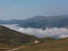
Yaylas
.jpg)
.
In the upper parts of Çaykara district there are six distinct yaylas (summer pastures), each with multiple hamlets. The most famous one of these is Sultan Murat Yaylası, which is shared by the hamlets İshakoğlu, Hanırmak, Şahinkaya, Eğrisu and Vartan.
Notable residents
- Cevdet Sunay (1899), Fifth president of Turkey
- Behram Kurşunoğlu (1922), physicist
- Orhan Tekeoğlu (1957), film director
- Yeşim Ustaoğlu (1960), architect and film director
- Yunus Vehbi Yavuz (1944) professor, academician, author
- Yusuf Şevki Yavuz (1953) professor, academician, author
- Salih Sabri Yavuz (1962) professor, academician, author
- Hasan Rami Yavuz (1909) scholar and lecturer, author
- Kemal Yazıcıoğlu (1941) Bureaucrat, governor
- Osman Turan (1914) Professor, politician
- Ali Rıza Uzuner (1926) Bureaucrat, ex-minister of labour
- Ismail Müftüoğlu (1939) Bureaucrat, ex-minister of justice
- A.Atilla Osmançelebioğlu (1947) Bureaucrat, governor
- Nusret Miroğlu (1947) Bureaucrat, governor
- Murat Mollamahmutoğlu (1959) professor, academician
- Seyfullah Hacımüftüoğlu (1960) Bureaucrat, governor
- Sebahattin Öztürk (1962) Bureaucrat, governor
- Ulvi Saran (1958) Bureaucrat, academician, governor
- Mevlüt Bilici (1961) Bureaucrat, governor
- Ismail Yüksek (1941) professor, academician, rector
- Hikmet Öksüz (1965) professor, academician
- Bekir Topaloğlu (1936) professor, academician, author
- Yaşar Yazıcıoğlu (???) Bureaucrat, politician, author
- Devlet Toksoy (1967) professor, academician
- Ali Fikri Yavuz (1924) scholar, author
- Eyüp Aşık (1953) politician, ex-parliamenter
- Ibrahim Cevahir (1938) businessman
- Atasoy Müftüoğlu (1942) researcher, author, thinker
- Erol Zihni Gürsoy (1955) bureaucrat, governor
- Ahmet Cemil Kara (1924) politician, ex-parliamenter
- Ali Naci Tuncer (1939) bureaucrat, ex-parliamenter
- Ayşe Doğan (1952) judge, member of supreme court
- Kerim Aydın (1953) musician,
- Mazhar Afacan (1940) businessmen, sportsman
- Mehmet Gedik (1953) politician, ex-parliamenter
- Mehmet Kara (1939) politician, ex-soldier
- Mehmet Zekai Özcan (1950) bureaucrat, politician
- Murat Bölükbaş (1980) professional football player
- Ümit Teke (1980) professional football player
- Zafer Cansız (1987) professional football player
- Ismail Yüksek (1963) scholar, academician, professor
- Ismail Inan (1918) politician, labour unionist
Mehmet Niyazoglu (1935) businessman, builder of Izmir Bus Terminal
Ahmet Cemal Niyazoglu (1944) theologist, researcher, author
See also
- Trabzon Province
- Trabzon
- Uzungöl
- Pontic Mountains
- Sultanmurat Plateau
References
- ↑ "Area of regions (including lakes), km²". Regional Statistics Database. Turkish Statistical Institute. 2002. Retrieved 2013-03-05.
- ↑ "Population of province/district centers and towns/villages by districts - 2012". Address Based Population Registration System (ABPRS) Database. Turkish Statistical Institute. Retrieved 2013-02-27.
- ↑ Karadeniz Ansiklopedik Sözlük: "Kadahor", by Özkan Öztürk. Istanbul, 2005.
- 1 2 3 History of Çaykara
- ↑ For daring drivers only: the world’s scariest roads Yahoo Travel, 24 April 2015
- ↑ Against all odds: archaic Greek in a modern world Cambridge Group for Endangered Languages and Cultures, 1 July 2010
- ↑ Schreiber, L. (2015). Assessing sociolinguistic vitality: an attitudinal study of Rumca (Romeyka) (Doctoral dissertation, Thesis). Free University of Berlin.
Further reading
- Michael Meeker, A Nation of Empire: The Ottoman Legacy of Turkish Modernity, 2002
- Margarita Poutouridou, The Of valley and the coming of Islam: the case of the Greek-speaking Muslims, 1997
- Erol Sağlam, Constitutive Ambiguities: Subjectivities and Memory in the Case of Romeika-Speaking Communities of Trabzon, Turkey, 2017
- Sitaridou, I. Greek-speaking enclaves in Pontus today: The documentation and revitalization of Romeyka, 2013