Dernekpazarı
| Dernekpazarı | |
|---|---|
 Dernekpazarı | |
| Coordinates: 40°48′N 40°14′E / 40.800°N 40.233°ECoordinates: 40°48′N 40°14′E / 40.800°N 40.233°E | |
| Country | Turkey |
| Province | Trabzon |
| Government | |
| • Mayor | Mehmet Aşık (AKP) |
| Area[1] | |
| • District | 81.91 km2 (31.63 sq mi) |
| Population (2012)[2] | |
| • Urban | 1,503 |
| • District | 3,485 |
| • District density | 43/km2 (110/sq mi) |
| Climate | Cfa |
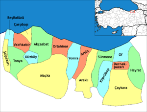
Dernekpazarı is a district of Trabzon Province in the Black Sea region of Turkey.The old name of the town was Kondu(or Kondualtı) and the current mayor of the town is Mehmet Aşık (AKP). Dernekpazarı is part of the Of-valley system ('Solaklı Vadisi' in Turkish); it lies between the coastal Of district and the alpine Çaykara district.
History
The colonists are considered the very first founders of Dernekpazari, but some historians argue that there were some Central Asian originated sedentary tribe people in town before colonists. The history of Dernekpazari is highly related to the history of the Trabzon(which is the biggest city of the Black Sea Region) and depending who is ruling the Trabzon Province, the town ruled by ancient Greeks, Persians, Romans, Byzantine Greeks and Ottoman Turks. While most of the villagers in the valley converted to Islam during the 17th and 18th centuries, some of the residents of the Dernekpazarı area retained their Christian faith. In the wake of the population exchange between Greece and Turkey in 1923 these Christian families chose to resettle in Greece, in the village of Nea Trapezounta. The Of-dialect of Pontic Greek (locally called 'Romeyka') is still spoken in the district.
Villages
The villages are listed north to south, with their Turkish and Greek names:
- Gülen - Visir / Βυζίρ'
- Dernekpazarı - Kondu / Κοντού
- Akköse - Zeno / Ζένο
- Zincirlitaş - Vezeno / Βετζονά
The following villages are part of the 'Holo' community in the southwest of the district:
- Yenice - Marladas / Μαρλαδάς
- Günebakan - Zenozena / Ζενόζενα
- Tüfekçi - Arşela / Αρσέλα
- Çalışanlar - Kalanas / Καλανός
- Ormancık - Makidanos / Μακιδάνος
- Taşçılar - Fotkene / Φώτγκενε
- Çayırbaşı - Havaşo / Χαβάσο
References
- ↑ "Area of regions (including lakes), km²". Regional Statistics Database. Turkish Statistical Institute. 2002. Retrieved 2013-03-05.
- ↑ "Population of province/district centers and towns/villages by districts - 2012". Address Based Population Registration System (ABPRS) Database. Turkish Statistical Institute. Retrieved 2013-02-27.
External links
- District governor's official website (in Turkish)