Tuolumne County
Tuolumne County, officieel de County of Tuolumne, is een van de 58 county's in de Amerikaanse deelstaat Californië. De county ligt in de Sierra Nevada, ten noorden van de Yosemite Valley en ten westen van Mono Lake. Het noorden van het Yosemite National Park ligt in Tuolumne County.
| County in de Verenigde Staten | |||
| |||
.svg.png) | |||
| Situering | |||
| Staat | Californië | ||
| Tijdzone | Pacific Standard Time (UTC−8) | ||
| Coördinaten | 38°1'12"NB, 119°56'24"WL | ||
| Algemeen | |||
| Oppervlakte | 5.890 km² | ||
| - land | 5.750 km² | ||
| - water | 140 km² | ||
| Inwoners (2010) | 55.365 (10 inw./km²) | ||
| Overig | |||
| Zetel | Sonora | ||
| FIPS-code | 06109 | ||
| Opgericht | 18 februari 1850 | ||
| Foto's | |||
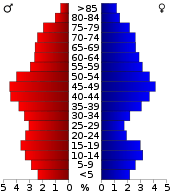 Bevolkingspiramide Tuolumne County | |||
| Statistieken volkstelling Tuolumne County | |||
| |||

Er wonen zo'n 55.000 mensen in Tuolumne County, verspreid over tientallen dorpen en gehuchten. De enige stad en hoofdplaats is Sonora, waar bijna 5.000 mensen wonen.
De naam is van indiaanse oorsprong, al is de betekenis en de precieze oorsprong onduidelijk.
Geografie
Tuolumne County heeft een totale oppervlakte van 5.890 km². Daarvan is 140 km² water. De county grenst aan Alpine County in het noorden, Calaveras County in het noordwesten, Stanislaus County in het zuidwesten, Mariposa County in het zuiden, Madera County in het zuidoosten en Mono County in het oosten.
Zie ook
Externe link
- (en) Officiële website
| Zie de categorie Tuolumne County van Wikimedia Commons voor mediabestanden over dit onderwerp. |
Hoofdstad: Sacramento
Regio's: Antelope Valley · Big Sur · Cascade Range · Central Coast · Central Valley · Channel Islands · Coachella Valley · Conejo Valley · Cucamonga Valley · Death Valley · East Bay · East County · Emerald Triangle · Gold Country · Greater Los Angeles · Grote Bekken · Imperial Valley · Inland Empire · Klamath Basin · Lake Tahoe · Los Angeles Basin · Lost Coast · Mojave · Mountain Empire · Noord-Californië · North Bay · North Coast · North County · Oost-Californië · Owens Valley · Oxnard Plain · San Francisco Peninsula · Pomona Valley · Sacramento Valley · San Bernardino Valley · San Diego–Tijuana · San Fernando Valley · San Francisco Bay Area · San Gabriel Valley · San Joaquin Valley · Santa Clara Valley · Santa Clarita Valley · Shasta Cascade · Sierra Nevada · Silicon Valley · South Bay (LA) · South Bay (SD) · South Bay (SF) · South Coast · Southern Border Region · Upstate California · Wine Country · Yosemite · Zuid-Californië
Metropolitane gebieden: Bakersfield · Chico · Fresno · Los Angeles-Long Beach-Glendale · Modesto · Napa · Oakland-Fremont-Hayward · Oxnard-Thousand Oaks-Ventura · Riverside-San Bernardino-Ontario · Sacramento-Roseville · Salinas · San Diego-Carlsbad-San Marcos · San Francisco-San Mateo-Redwood City · San Jose-Sunnyvale-Santa Clara · San Luis Obispo-Paso Robles · Santa Ana-Anaheim-Irvine · Santa Barbara-Santa Maria · Santa Cruz-Watsonville · Santa Rosa-Petaluma · Stockton · Vallejo-Fairfield · Visalia-Porterville · Yuba City
County's: Alameda · Alpine · Amador · Butte · Calaveras · Colusa · Contra Costa · Del Norte · El Dorado · Fresno · Glenn · Humboldt · Imperial · Inyo · Kern · Kings · Lake · Lassen · Los Angeles · Madera · Marin · Mariposa · Mendocino · Merced · Modoc · Mono · Monterey · Napa · Nevada · Orange · Placer · Plumas · Riverside · Sacramento · San Benito · San Bernardino · San Diego · San Francisco · San Joaquin · San Luis Obispo · San Mateo · Santa Barbara · Santa Clara · Santa Cruz · Shasta · Sierra · Siskiyou · Solano · Sonoma · Stanislaus · Sutter · Tehama · Trinity · Tulare · Tuolumne · Ventura · Yolo · Yuba
Portaal Californië