Monterey County
Monterey County is een van de 58 county's in de Amerikaanse deelstaat Californië. Monterey County ligt aan de Stille Oceaan in de Central Coast-regio. In het noordwesten ligt de Baai van Monterey en in het oosten ligt de agrarische Salinas Valley, met daarin de hoofdplaats Salinas. Het merendeel van de 415.057 inwoners (2010) woont in de buurt van de baai of in de Salinas-vallei, terwijl het zuiden en het bergachtige binnenland relatief dunbevolkt zijn. De kust van Monterey County is erg toeristisch.
| County in de Verenigde Staten | |||
.svg.png) | |||
| Situering | |||
| Staat | Californië | ||
| Tijdzone | Pacific Standard Time (UTC−8) | ||
| Coördinaten | 36°14'24"NB, 121°18'36"WL | ||
| Algemeen | |||
| Oppervlakte | 9.767 km² | ||
| - land | 8.603,8 km² | ||
| - water | 1.163,2 km² | ||
| Inwoners (2010) | 415.057 (48 inw./km²) | ||
| Overig | |||
| Zetel | Salinas | ||
| FIPS-code | 06053 | ||
| Opgericht | 18 februari 1850 | ||
| Foto's | |||
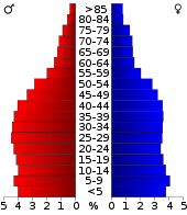 Bevolkingspiramide Monterey County | |||
| Statistieken volkstelling Monterey County | |||
| |||
Geografie
De county heeft een totale oppervlakte van 9767 km² (3771 mijl²) waarvan 8604 km² (3322 mijl²) land is en 1163 km² (449 mijl²) of 11.91% water is.
Aangrenzende county's
- San Luis Obispo County - zuiden
- Kings County - zuidoost
- Fresno County - zuidoost
- San Benito County - oosten
- Santa Cruz County - noorden
Steden en dorpen
Demografie
De volkstelling van 2010 door het United States Census Bureau wees uit dat Monterey County 415.057 inwoners telde. De etnische samenstelling was als volgt: 55,6% blank, 6,1% Aziatisch, 3,1% Afro-Amerikaans, 1,3% indiaans en 0,5% afkomstig van de eilanden in de Stille Oceaan. Daarnaast gaf 28,3% van de inwoners aan tot een ander ras te behoren en 5,1% rekende zichzelf tot twee of meer rassen. Van de totale bevolking was 55,4% Hispanic of Latino. In Monterey County is er een absolute meerderheid (50,2%) van inwoners van Mexicaanse origine.
Externe links
- (en) Officiële website
- (en) Censusgegevens
Hoofdstad: Sacramento
Regio's: Antelope Valley · Big Sur · Cascade Range · Central Coast · Central Valley · Channel Islands · Coachella Valley · Conejo Valley · Cucamonga Valley · Death Valley · East Bay · East County · Emerald Triangle · Gold Country · Greater Los Angeles · Grote Bekken · Imperial Valley · Inland Empire · Klamath Basin · Lake Tahoe · Los Angeles Basin · Lost Coast · Mojave · Mountain Empire · Noord-Californië · North Bay · North Coast · North County · Oost-Californië · Owens Valley · Oxnard Plain · San Francisco Peninsula · Pomona Valley · Sacramento Valley · San Bernardino Valley · San Diego–Tijuana · San Fernando Valley · San Francisco Bay Area · San Gabriel Valley · San Joaquin Valley · Santa Clara Valley · Santa Clarita Valley · Shasta Cascade · Sierra Nevada · Silicon Valley · South Bay (LA) · South Bay (SD) · South Bay (SF) · South Coast · Southern Border Region · Upstate California · Wine Country · Yosemite · Zuid-Californië
Metropolitane gebieden: Bakersfield · Chico · Fresno · Los Angeles-Long Beach-Glendale · Modesto · Napa · Oakland-Fremont-Hayward · Oxnard-Thousand Oaks-Ventura · Riverside-San Bernardino-Ontario · Sacramento-Roseville · Salinas · San Diego-Carlsbad-San Marcos · San Francisco-San Mateo-Redwood City · San Jose-Sunnyvale-Santa Clara · San Luis Obispo-Paso Robles · Santa Ana-Anaheim-Irvine · Santa Barbara-Santa Maria · Santa Cruz-Watsonville · Santa Rosa-Petaluma · Stockton · Vallejo-Fairfield · Visalia-Porterville · Yuba City
County's: Alameda · Alpine · Amador · Butte · Calaveras · Colusa · Contra Costa · Del Norte · El Dorado · Fresno · Glenn · Humboldt · Imperial · Inyo · Kern · Kings · Lake · Lassen · Los Angeles · Madera · Marin · Mariposa · Mendocino · Merced · Modoc · Mono · Monterey · Napa · Nevada · Orange · Placer · Plumas · Riverside · Sacramento · San Benito · San Bernardino · San Diego · San Francisco · San Joaquin · San Luis Obispo · San Mateo · Santa Barbara · Santa Clara · Santa Cruz · Shasta · Sierra · Siskiyou · Solano · Sonoma · Stanislaus · Sutter · Tehama · Trinity · Tulare · Tuolumne · Ventura · Yolo · Yuba
Portaal Californië