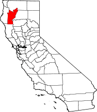
Trinity County (Californië)
Trinity County is een county in Californië in de VS. Het was een van de eerste county's en werd gevormd in 1850.
| County in de Verenigde Staten | |||
 | |||
| Situering | |||
| Staat | Californië | ||
| Coördinaten | 40°39'36"NB, 123°7'12"WL | ||
| Algemeen | |||
| Oppervlakte | 8.308 km² | ||
| - land | 8.233 km² | ||
| - water | 75 km² | ||
| Inwoners (2000) | 13.022 (2 inw./km²) | ||
| Overig | |||
| FIPS-code | 06105 | ||
| Foto's | |||
 Bevolkingspiramide Trinity County | |||
| Statistieken volkstelling Trinity County | |||
| |||
Het kreeg zijn naam van de Trinity River, ontdekt in 1848 door majoor Pearson B. Reading.
Geschiedenis
Trinity County had in de 19e eeuw een bloeiende Chinese migrantengemeenschap. De meeste Chinese Amerikanen hier deden aan goudzoeken in de bergen. Rond 1880 woonden er bijna tweeduizend Chinese Amerikanen in deze county. Er waren drie daoïstische tempels. Tegenwoordig is de Won Lim Temple, die al in 1853 bestond, een toeristische attractie, maar heeft nog wel haar religieuze functie kunnen behouden door de familie Moon Lee en andere religieuze mensen.[1]
Geografie
De county heeft een totale oppervlakte van 8307 km² (3208 mijl²) waarvan 8233 km² (3179 mijl²) land is en 75 km² (29 mijl²) of 0.90% water is.
Aangrenzende county's
- Mendocino County - zuiden
- Humboldt County - westen
- Siskiyou County - noorden
- Shasta County - oosten
- Tehama County - zuidoost
Steden en dorpen
Zie ook
Externe links
Hoofdstad: Sacramento
Regio's: Antelope Valley · Big Sur · Cascade Range · Central Coast · Central Valley · Channel Islands · Coachella Valley · Conejo Valley · Cucamonga Valley · Death Valley · East Bay · East County · Emerald Triangle · Gold Country · Greater Los Angeles · Grote Bekken · Imperial Valley · Inland Empire · Klamath Basin · Lake Tahoe · Los Angeles Basin · Lost Coast · Mojave · Mountain Empire · Noord-Californië · North Bay · North Coast · North County · Oost-Californië · Owens Valley · Oxnard Plain · San Francisco Peninsula · Pomona Valley · Sacramento Valley · San Bernardino Valley · San Diego–Tijuana · San Fernando Valley · San Francisco Bay Area · San Gabriel Valley · San Joaquin Valley · Santa Clara Valley · Santa Clarita Valley · Shasta Cascade · Sierra Nevada · Silicon Valley · South Bay (LA) · South Bay (SD) · South Bay (SF) · South Coast · Southern Border Region · Upstate California · Wine Country · Yosemite · Zuid-Californië
Metropolitane gebieden: Bakersfield · Chico · Fresno · Los Angeles-Long Beach-Glendale · Modesto · Napa · Oakland-Fremont-Hayward · Oxnard-Thousand Oaks-Ventura · Riverside-San Bernardino-Ontario · Sacramento-Roseville · Salinas · San Diego-Carlsbad-San Marcos · San Francisco-San Mateo-Redwood City · San Jose-Sunnyvale-Santa Clara · San Luis Obispo-Paso Robles · Santa Ana-Anaheim-Irvine · Santa Barbara-Santa Maria · Santa Cruz-Watsonville · Santa Rosa-Petaluma · Stockton · Vallejo-Fairfield · Visalia-Porterville · Yuba City
County's: Alameda · Alpine · Amador · Butte · Calaveras · Colusa · Contra Costa · Del Norte · El Dorado · Fresno · Glenn · Humboldt · Imperial · Inyo · Kern · Kings · Lake · Lassen · Los Angeles · Madera · Marin · Mariposa · Mendocino · Merced · Modoc · Mono · Monterey · Napa · Nevada · Orange · Placer · Plumas · Riverside · Sacramento · San Benito · San Bernardino · San Diego · San Francisco · San Joaquin · San Luis Obispo · San Mateo · Santa Barbara · Santa Clara · Santa Cruz · Shasta · Sierra · Siskiyou · Solano · Sonoma · Stanislaus · Sutter · Tehama · Trinity · Tulare · Tuolumne · Ventura · Yolo · Yuba
Portaal Californië
| Bronnen, noten en/of referenties |