Stanislaus County
Stanislaus County is een van de 58 county's in de Amerikaanse deelstaat Californië. Stanislaus County ligt in het noorden van de San Joaquin Valley in het midden van Californië. De county is vernoemd naar de Stanislaus, een zijrivier van de San Joaquin, die eveneens over het grondgebied stroomt.
| County in de Verenigde Staten | |||
.svg.png) | |||
| Situering | |||
| Staat | Californië | ||
| Tijdzone | Pacific Standard Time (UTC−8) | ||
| Coördinaten | 37°33'36"NB, 120°59'24"WL | ||
| Algemeen | |||
| Oppervlakte | 3.920 km² | ||
| - land | 3.870 km² | ||
| - water | 50 km² | ||
| Inwoners (2010) | 514.453 (133 inw./km²) | ||
| Overig | |||
| Zetel | Modesto | ||
| FIPS-code | 06099 | ||
| Opgericht | 1 april 1854 | ||
| Foto's | |||
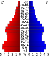 Bevolkingspiramide Stanislaus County | |||
| Statistieken volkstelling Stanislaus County | |||
| |||
Volgens de volkstelling van 2010 woonden er 514.453 mensen in Stanislaus County. Een derde van de bevolking is hispanic of latino. De hoofdplaats en grootste stad is Modesto. Andere belangrijke plaatsen zijn Turlock, Ceres, Riverbank, Oakdale en Patterson.
De economie van Stanislaus County is sterk gericht op de landbouw. Als een gevolg van de extreem hoge huizenprijzen in de San Francisco Bay Area, ten westen van Stanislaus County, verhuisden er de laatste decennia veel pendelaars van de Bay Area naar dorpen en stadjes in Stanislaus County, waar het in vergelijking nog goedkoop wonen is. De ligging van plaatsen als Patterson en Newman langs de Interstate 5 speelt daarin zeker een rol.
Geografie
De county heeft een totale oppervlakte van 3923 km² (1515 mijl²) waarvan 3869 km² (1494 mijl²) land is en 54 km² (21 mijl²) of 1.38% water is.
Aangrenzende county's
- Santa Clara County - zuidwest
- San Joaquin County - noordwest
- Calaveras County - noorden
- Tuolumne County - noordoost
- Merced County - zuiden
Externe link
- (en) Officiële website
| Zie de categorie Stanislaus County van Wikimedia Commons voor mediabestanden over dit onderwerp. |
Hoofdstad: Sacramento
Regio's: Antelope Valley · Big Sur · Cascade Range · Central Coast · Central Valley · Channel Islands · Coachella Valley · Conejo Valley · Cucamonga Valley · Death Valley · East Bay · East County · Emerald Triangle · Gold Country · Greater Los Angeles · Grote Bekken · Imperial Valley · Inland Empire · Klamath Basin · Lake Tahoe · Los Angeles Basin · Lost Coast · Mojave · Mountain Empire · Noord-Californië · North Bay · North Coast · North County · Oost-Californië · Owens Valley · Oxnard Plain · San Francisco Peninsula · Pomona Valley · Sacramento Valley · San Bernardino Valley · San Diego–Tijuana · San Fernando Valley · San Francisco Bay Area · San Gabriel Valley · San Joaquin Valley · Santa Clara Valley · Santa Clarita Valley · Shasta Cascade · Sierra Nevada · Silicon Valley · South Bay (LA) · South Bay (SD) · South Bay (SF) · South Coast · Southern Border Region · Upstate California · Wine Country · Yosemite · Zuid-Californië
Metropolitane gebieden: Bakersfield · Chico · Fresno · Los Angeles-Long Beach-Glendale · Modesto · Napa · Oakland-Fremont-Hayward · Oxnard-Thousand Oaks-Ventura · Riverside-San Bernardino-Ontario · Sacramento-Roseville · Salinas · San Diego-Carlsbad-San Marcos · San Francisco-San Mateo-Redwood City · San Jose-Sunnyvale-Santa Clara · San Luis Obispo-Paso Robles · Santa Ana-Anaheim-Irvine · Santa Barbara-Santa Maria · Santa Cruz-Watsonville · Santa Rosa-Petaluma · Stockton · Vallejo-Fairfield · Visalia-Porterville · Yuba City
County's: Alameda · Alpine · Amador · Butte · Calaveras · Colusa · Contra Costa · Del Norte · El Dorado · Fresno · Glenn · Humboldt · Imperial · Inyo · Kern · Kings · Lake · Lassen · Los Angeles · Madera · Marin · Mariposa · Mendocino · Merced · Modoc · Mono · Monterey · Napa · Nevada · Orange · Placer · Plumas · Riverside · Sacramento · San Benito · San Bernardino · San Diego · San Francisco · San Joaquin · San Luis Obispo · San Mateo · Santa Barbara · Santa Clara · Santa Cruz · Shasta · Sierra · Siskiyou · Solano · Sonoma · Stanislaus · Sutter · Tehama · Trinity · Tulare · Tuolumne · Ventura · Yolo · Yuba
Portaal Californië