Isle of Wight County
Isle of Wight County is een van de 95 county's in de Amerikaanse staat Virginia. Daarnaast kent Virginia 39 onafhankelijke steden die niet tot county's behoren.
| County in de Verenigde Staten | |||
 | |||
| Situering | |||
| Staat | Virginia | ||
| Tijdzone | Eastern Standard Time (UTC−5) | ||
| Coördinaten | 36°54'36"NB, 76°42'36"WL | ||
| Algemeen | |||
| Oppervlakte | 939 km² | ||
| - land | 818 km² | ||
| - water | 121 km² | ||
| Inwoners (2000) | 29.728 (36 inw./km²) | ||
| Overig | |||
| Zetel | Isle Of Wight | ||
| FIPS-code | 51093 | ||
| Opgericht | 1634 | ||
| Foto's | |||
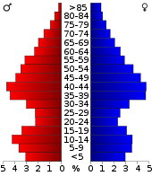 Bevolkingspiramide Isle of Wight County | |||
| Statistieken volkstelling Isle of Wight County | |||
| |||
De county heeft een landoppervlakte van 818 km² en telt 29.728 inwoners (volkstelling 2000). De hoofdplaats is Isle Of Wight.
Bevolkingsontwikkeling
| Historische inwonertallen | |||
|---|---|---|---|
| Jaar | Inwoners | % ± | |
| 1900 | 13.102 | ||
| 1910 | 14.929 | 13,9% | |
| 1920 | 14.433 | −3,3% | |
| 1930 | 13.409 | −7,1% | |
| 1940 | 13.381 | −0,2% | |
| 1950 | 14.906 | 11,4% | |
| 1960 | 17.164 | 15,1% | |
| 1970 | 18.285 | 6,5% | |
| 1980 | 21.603 | 18,1% | |
| 1990 | 25.053 | 16,0% | |
| 2000 | 29.728 | 18,7% | |
| Bron: (en) Historical Decennial Census Population | |||

Isle of Wight County Courthouse
This article is issued from
Wikipedia.
The text is licensed under Creative
Commons - Attribution - Sharealike.
Additional terms may apply for the media files.