Grayson County (Virginia)
Grayson County is een van de 95 county's in de Amerikaanse staat Virginia. Daarnaast kent Virginia 39 onafhankelijke steden die niet tot county's behoren.
| County in de Verenigde Staten | |||
 | |||
| Situering | |||
| Staat | Virginia | ||
| Tijdzone | Eastern Standard Time (UTC−5) | ||
| Coördinaten | 36°39'0"NB, 81°13'48"WL | ||
| Algemeen | |||
| Oppervlakte | 1.154 km² | ||
| - land | 1.146 km² | ||
| - water | 8 km² | ||
| Inwoners (2000) | 17.917 (16 inw./km²) | ||
| Overig | |||
| Zetel | Independence | ||
| FIPS-code | 51077 | ||
| Opgericht | 1793 | ||
| Foto's | |||
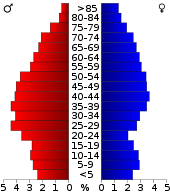 Bevolkingspiramide Grayson County | |||
| Statistieken volkstelling Grayson County | |||
| |||
De county heeft een landoppervlakte van 1.146 km² en telt 17.917 inwoners (volkstelling 2000). De hoofdplaats is Independence.
Bevolkingsontwikkeling
| Historische inwonertallen | |||
|---|---|---|---|
| Jaar | Inwoners | % ± | |
| 1900 | 16.853 | ||
| 1910 | 19.856 | 17,8% | |
| 1920 | 19.816 | −0,2% | |
| 1930 | 20.017 | 1,0% | |
| 1940 | 21.916 | 9,5% | |
| 1950 | 21.379 | −2,5% | |
| 1960 | 17.390 | −18,7% | |
| 1970 | 15.439 | −11,2% | |
| 1980 | 16.579 | 7,4% | |
| 1990 | 16.278 | −1,8% | |
| 2000 | 17.917 | 10,1% | |
| Bron: (en) Historical Decennial Census Population | |||
| Zie de categorie Grayson County, Virginia van Wikimedia Commons voor mediabestanden over dit onderwerp. |
This article is issued from
Wikipedia.
The text is licensed under Creative
Commons - Attribution - Sharealike.
Additional terms may apply for the media files.