Clarke County (Virginia)
Clarke County is een van de 95 county's in de Amerikaanse staat Virginia. Daarnaast kent Virginia 39 onafhankelijke steden die niet tot county's behoren.
| County in de Verenigde Staten | |||
 | |||
| Situering | |||
| Staat | Virginia | ||
| Tijdzone | Eastern Standard Time (UTC−5) | ||
| Coördinaten | 39°7'12"NB, 78°0'0"WL | ||
| Algemeen | |||
| Oppervlakte | 461 km² | ||
| - land | 457 km² | ||
| - water | 4 km² | ||
| Inwoners (2000) | 12.652 (28 inw./km²) | ||
| Overig | |||
| Zetel | Berryville | ||
| FIPS-code | 51043 | ||
| Opgericht | 1836 | ||
| Foto's | |||
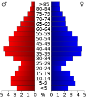 Bevolkingspiramide Clarke County | |||
| Statistieken volkstelling Clarke County | |||
| |||
De county heeft een landoppervlakte van 457 km² en telt 12.652 inwoners (volkstelling 2000). De hoofdplaats is Berryville.
Bevolkingsontwikkeling
| Historische inwonertallen | |||
|---|---|---|---|
| Jaar | Inwoners | % ± | |
| 1900 | 7.927 | ||
| 1910 | 7.468 | −5,8% | |
| 1920 | 7.165 | −4,1% | |
| 1930 | 7.167 | 0,0% | |
| 1940 | 7.159 | −0,1% | |
| 1950 | 7.074 | −1,2% | |
| 1960 | 7.942 | 12,3% | |
| 1970 | 8.102 | 2,0% | |
| 1980 | 9.965 | 23,0% | |
| 1990 | 12.101 | 21,4% | |
| 2000 | 12.652 | 4,6% | |
| Bron: (en) Historical Decennial Census Population | |||

Clarke County Courthouse
This article is issued from
Wikipedia.
The text is licensed under Creative
Commons - Attribution - Sharealike.
Additional terms may apply for the media files.