Goochland County
Goochland County is een van de 95 county's in de Amerikaanse staat Virginia. Daarnaast kent Virginia 39 onafhankelijke steden die niet tot county's behoren.
| County in de Verenigde Staten | |||
 | |||
| Situering | |||
| Staat | Virginia | ||
| Tijdzone | Eastern Standard Time (UTC−5) | ||
| Coördinaten | 37°43'12"NB, 77°55'48"WL | ||
| Algemeen | |||
| Oppervlakte | 751 km² | ||
| - land | 737 km² | ||
| - water | 14 km² | ||
| Inwoners (2000) | 16.863 (23 inw./km²) | ||
| Overig | |||
| Zetel | Goochland | ||
| FIPS-code | 51075 | ||
| Opgericht | 1727 | ||
| Foto's | |||
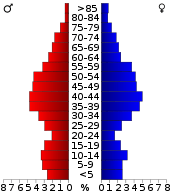 Bevolkingspiramide Goochland County | |||
| Statistieken volkstelling Goochland County | |||
| |||
De county heeft een landoppervlakte van 737 km² en telt 16.863 inwoners (volkstelling 2000). De hoofdplaats is Goochland.
Bevolkingsontwikkeling
| Historische inwonertallen | |||
|---|---|---|---|
| Jaar | Inwoners | % ± | |
| 1900 | 9.519 | ||
| 1910 | 9.237 | −3,0% | |
| 1920 | 8.863 | −4,0% | |
| 1930 | 7.953 | −10,3% | |
| 1940 | 8.454 | 6,3% | |
| 1950 | 8.934 | 5,7% | |
| 1960 | 9.206 | 3,0% | |
| 1970 | 10.069 | 9,4% | |
| 1980 | 11.761 | 16,8% | |
| 1990 | 14.163 | 20,4% | |
| 2000 | 16.863 | 19,1% | |
| Bron: (en) Historical Decennial Census Population | |||
.jpg)
Goochland County Courthouse
This article is issued from
Wikipedia.
The text is licensed under Creative
Commons - Attribution - Sharealike.
Additional terms may apply for the media files.