Botetourt County
Botetourt County is een van de 95 county's in de Amerikaanse staat Virginia. Daarnaast kent Virginia 39 onafhankelijke steden die niet tot county's behoren.
| County in de Verenigde Staten | |||
 | |||
| Situering | |||
| Staat | Virginia | ||
| Tijdzone | Eastern Standard Time (UTC−5) | ||
| Coördinaten | 37°33'NB, 79°48'WL | ||
| Algemeen | |||
| Oppervlakte | 1.413 km² | ||
| - land | 1.405 km² | ||
| - water | 8 km² | ||
| Inwoners (2000) | 30.496 (22 inw./km²) | ||
| Overig | |||
| Zetel | Fincastle | ||
| FIPS-code | 51023 | ||
| Opgericht | 1769 | ||
| Foto's | |||
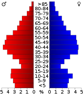 Bevolkingspiramide Botetourt County | |||
| Statistieken volkstelling Botetourt County | |||
| |||
De county heeft een landoppervlakte van 1.405 km² en telt 30.496 inwoners (volkstelling 2000). De hoofdplaats is Fincastle.
Bevolkingsontwikkeling
| Historische inwonertallen | |||
|---|---|---|---|
| Jaar | Inwoners | % ± | |
| 1900 | 17.161 | ||
| 1910 | 17.727 | 3,3% | |
| 1920 | 16.557 | −6,6% | |
| 1930 | 15.457 | −6,6% | |
| 1940 | 16.447 | 6,4% | |
| 1950 | 15.766 | −4,1% | |
| 1960 | 16.715 | 6,0% | |
| 1970 | 18.193 | 8,8% | |
| 1980 | 23.270 | 27,9% | |
| 1990 | 24.992 | 7,4% | |
| 2000 | 30.496 | 22,0% | |
| Bron: (en) Historical Decennial Census Population | |||
This article is issued from
Wikipedia.
The text is licensed under Creative
Commons - Attribution - Sharealike.
Additional terms may apply for the media files.