Augusta County
Augusta County is een van de 95 county's in de Amerikaanse staat Virginia. Daarnaast kent Virginia 39 onafhankelijke steden die niet tot county's behoren.
| County in de Verenigde Staten | |||
 | |||
| Situering | |||
| Staat | Virginia | ||
| Tijdzone | Eastern Standard Time (UTC−5) | ||
| Coördinaten | 38°12'NB, 79°6'WL | ||
| Algemeen | |||
| Oppervlakte | 2.514 km² | ||
| - land | 2.513 km² | ||
| - water | 1 km² | ||
| Inwoners (2000) | 65.615 (26 inw./km²) | ||
| Overig | |||
| Zetel | Verona | ||
| FIPS-code | 51015 | ||
| Opgericht | 1738 | ||
| Foto's | |||
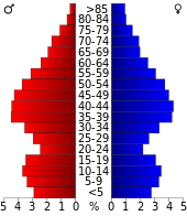 Bevolkingspiramide Augusta County | |||
| Statistieken volkstelling Augusta County | |||
| |||
De county heeft een landoppervlakte van 2.513 km² en telt 65.615 inwoners (volkstelling 2000). De hoofdplaats is Verona.
Bevolkingsontwikkeling
| Historische inwonertallen | |||
|---|---|---|---|
| Jaar | Inwoners | % ± | |
| 1900 | 32.370 | ||
| 1910 | 32.445 | 0,2% | |
| 1920 | 34.671 | 6,9% | |
| 1930 | 38.163 | 10,1% | |
| 1940 | 42.772 | 12,1% | |
| 1950 | 34.154 | −20,1% | |
| 1960 | 37.363 | 9,4% | |
| 1970 | 44.220 | 18,4% | |
| 1980 | 53.732 | 21,5% | |
| 1990 | 54.677 | 1,8% | |
| 2000 | 65.615 | 20,0% | |
| Bron: (en) Historical Decennial Census Population | |||

Augusta County Courthouse
This article is issued from
Wikipedia.
The text is licensed under Creative
Commons - Attribution - Sharealike.
Additional terms may apply for the media files.