Volta River
The Volta River is the main river system in the West African country of Ghana. It flows into Ghana from Bobo-Dioulasso highlands of Burkina Faso. The main part of the river are the Black Volta, the White Volta, and the Red Volta. In the northwest, the Black Volta forms the international borders between the Ivory Coast, Ghana, and Burkina Faso. The Volta flows southward along Akwapim-Togoland highlands, and it empties into the Atlantic Ocean at the Gulf of Guinea at Ada. It has a smaller tributary river, the Oti, which enters Ghana from Togo in the east. The Volta River has been dammed at Akosombo for the purpose of generating hydroelectricity. The reservoir named Lake Volta stretches from Akosombo in the south to the northern part of the country, thus being one of the largest man-made reservoirs in the world.[4]
| Volta River | |
|---|---|
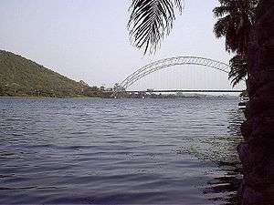 The Adome Bridge crosses the Volta river south of the Akosombo Dam. | |
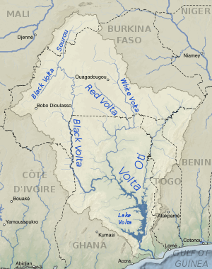 Map of the Volta River drainage basin and its main three tributaries, the White Volta, Red Volta, and Black Volta rivers. | |
| Location | |
| Country | Ghana, Burkina Faso, Ivory Coast |
| Physical characteristics | |
| Mouth | Gulf of Guinea |
• location | Atlantic Ocean |
• coordinates | 5°46′N 0°41′E[1] |
| Length | 1,500 km (930 mi) |
| Basin size | 407,093 km2 (157,179 sq mi)[2] |
| Discharge | |
| • location | Mouth[3] |
| • average | 1,210 m3/s (43,000 cu ft/s)[3] |
The Reservoir
Lake Volta is a reservoir impounded by the Akosombo Dam on the lower Volta River in southern Ghana. It is one of the largest reservoirs in the world. It extends from the Akosombo Dam in southeastern Ghana to the town of Yapei in the Central Gonja District, Northern Region of Ghana, some 400 kilometres (250 mi) to the north.
The dam's power plant generates electricity for the Volta River Authority, and the reservoir also provides water transport routes. It may be a resource for irrigation and fish farming.
The depth of the river is about 45 feet (14 m) below Lake Volta. The Volta River is crossed by the Adome Bridge just below the Akosombo Dam.
History
The Volta River was named by Portuguese gold traders in Ghana. It was their farthest extent of exploration before returning (volta is Portuguese for "twist" or "turn").[5] "River of return" (perhaps because it was where ships turned around and headed for home) or “river of the bend”, in reference to its curved course.[5][6]
See also
- Impacts of the Akosombo Hydroelectric Project — environmental and human health issues from the Akosombo Dam and Lake Volta.
References
- Volta at GEOnet Names Server
- Volta Archived 2005-10-26 at the Wayback Machine, Watersheds of the World. Water Resources eAtlas. Retrieved on October 6, 2007.
- Volta River, Encyclopædia Britannica. 2007. Encyclopædia Britannica Online Library Edition. Retrieved on October 6, 2007.
- "Lake Volta, Ghana". Visible Earth. NASA. Retrieved 7 March 2018.
- Volta - etymology
- Wilks,Ivor. Wangara, Akan, and Portuguese in the Fifteenth and Sixteenth Centuries (1997). Bakewell, Peter (ed.). Mines of Silver and Gold in the Americas. Aldershot: Variorum, Ashgate Publishing Limited. p. 15.CS1 maint: multiple names: authors list (link)
![]()
| Authority control |
|
|---|