Uglich Reservoir
Uglich Reservoir or Uglichskoye Reservoir (Russian: У́гличское водохрани́лище) is an artificial lake in the upper part of the Volga River formed by the Uglich Hydroelectric Station dam.
| Uglich Reservoir | |
|---|---|
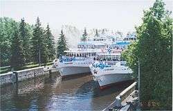 A lock at Uglich Reservoir | |
| Coordinates | 57°15′N 37°50′E |
| Type | Hydroelectric reservoir |
| Primary inflows | Volga, Medveditsa, Kashinka, Nerl |
| Basin countries | Russia |
| Max. length | 143 km (89 mi) |
| Max. width | 5 km (3.1 mi) |
| Surface area | 249 km2 (96 sq mi) |
| Average depth | 5 m (16 ft) |
| Water volume | 1.24 km3 (0.30 cu mi) |
| Settlements | Kaliazin, Kimry |
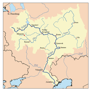
It was built in 1939 in the town of Uglich. It is located in Tver and Yaroslavl Oblasts in central Russia.
Description
The Uglich Reservoir has a surface area of 249 km² and a water volume of 1.2 km3. Its length is 143 km, it maximum width is 5 km, and average depth is 5 m (with maximum depth equaling 23 m). The Uglich Reservoir was created for the benefit of transportation, energy, and water supply. It also performs seasonal flow regulation. The towns of Uglich, Kalyazin, and Kimry are located along the reservoir.
- Consequences
The construction of the dam led to a 15th-century monastery in Uglich and 16th-century monastery in Kalyazin being submerged by the artificial lake. The Flooded Belfry is an example of a submerged landmark.
See also
| Wikimedia Commons has media related to Uglich Reservoir. |
References
This article includes content derived from the Great Soviet Encyclopedia, 1969–1978, which is partially in the public domain.
The river Volga | ||
|---|---|---|
| Tributaries |
|  |
| Reservoirs | ||
| Hydroelectric stations | ||
| Canals | ||
| Cities | ||